Qassiarsuk

Last updated
Qassiarsuk
Brattachurch.jpg
Reproduction of Brattahlíð church, Qassiarsuk
Greenland edcp location map.svg
Red pog.svg
Qassiarsuk
Location within Greenland
Coordinates: 61°09′00″N45°31′00″W / 61.15000°N 45.51667°W / 61.15000; -45.51667 Coordinates: 61°09′00″N45°31′00″W / 61.15000°N 45.51667°W / 61.15000; -45.51667
StateFlag of Denmark (state).svg  Kingdom of Denmark
Constituent country Flag of Greenland.svg  Greenland
Municipality Kujalleq-coat-of-arms.svg Kujalleq
Government
[1]
  MayorFredrik Frederiksen
Population
 (2020)
  Total39
Time zone UTC-03
Postal code
3921 Narsaq

Qassiarsuk is a settlement in the Kujalleq municipality, in southern Greenland. Its population was 39 in 2020. [2] Qassiarsuk is part of the Kujataa World Heritage Site, due to its historical importance as the homestead of Erik the Red and its unique testimony to Greenlandic farming. [3]

Contents

History

Brattahlíð is located by Tunulliarfik Fjord (Skovfjorden in Danish), and it was the site of Erik the Red's estate in the times of the Norse Eastern Settlement (Østerbygden in Danish). Ruins of several of the buildings, including living quarters, outhouses, and a church, are still clearly visible. [4]

The current village was founded as Greenland's first sheep farm in 1924 and is located in the same place.

Until December 31, 2008, the settlement was part of Narsaq Municipality in the Kitaa amt. On January 1, 2009, Qassiarsuk became part of Kujalleq municipality, when the Kitaa amt, as well as the municipalities of Narsaq, Qaqortoq, and Nanortalik ceased to exist as administrative entities.

Geography

Aerial view of the farms of Qassiarsuk from the north Tunulliarfik-qassiarsuk.jpg
Aerial view of the farms of Qassiarsuk from the north

The settlement is located on Narsaq Peninsula roughly 5 km (3.1 mi) west of Narsarsuaq across the Tunulliarfik Fjord. It has fertile plains wider than those found at Narsaq on the southern end of the peninsula.

Infrastructure and transportation

The settlement has a general store operated by KNI, [5] and there is a youth hostel available for tourists and hikers. There is also a small church.

The electricity needs for the settlement are provided for by a local power station.

Transportation

The Qassiarsuk area has a relatively extensive network of traversable dirt and gravel roads, totalling over 120 kilometers and requiring DKK 500,000 annually for service. [6] The roads are mainly needed for the sheep farming. The longest stretch of road connects the sheep farms of Qassiarsuk with the airport of Narsarsuaq, around 50 km. The roads are generally of poor construction, lacking crossfall for drainage, and using softer sandstone instead of harder granite, creating severe dust problems in the summer. For general transportation all-terrain vehicles are recommended. Driving between the airport and Qassiarsuk is hard since there is no bridge over the glacial Narsarsuaq river and crossing it is difficult due to deposits of silt quicksand the river carries from the Greenland ice sheet (Greenlandic : Sermersuaq).

All vital transportation at Qassiarsuk is by sea, with boats linking the settlement to Narsarsuaq Airport, home to the only international airport in southern Greenland. The airport primarily functions as a transfer point for passengers heading for the helicopter hubs of Air Greenland in Qaqortoq and Nanortalik. Qassiarsuk does not have its own heliport.

Economy

Qassiarsuk's economy is based on sheep husbandry and farming. This contrasts with the majority of Greenland's settlements, which are based on fishing.

There is also a thriving tourism industry in the area. [7] The Norse ruins in the area and the reconstructed Thodhildur's church [8] of Brattahlid are among the most popular tourist destinations in all of Greenland. [9]

Population

The population of Qassiarsuk has been stable in the last two decades. [10]

Qassiarsuk-population-dynamics.png
Qassiarsuk population growth dynamics in the last two decades. Source: Statistics Greenland [10]

In Literature

The novel An Old Captivity by Nevil Shute is set in Brattahlíð (spelled "Brattalid" in the book), describing a 1930s archaeological expedition there.

Related Research Articles

Narsarsuaq Place in Greenland, Kingdom of Denmark

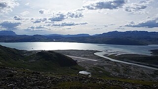
Narsarsuaq is a settlement in the Kujalleq municipality in southern Greenland. It had 123 inhabitants in 2020. There is a thriving tourism industry in and around Narsarsuaq, whose attractions include a great diversity of wildlife, gemstones, tours to glaciers, and an airfield museum.

Brattahlíð Archaeological site in Greenland

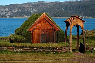
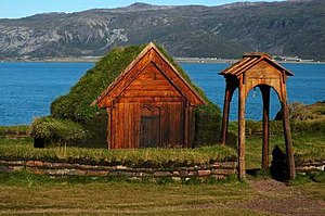
Brattahlíð, often anglicised as Brattahlid, was Erik the Red's estate in the Eastern Settlement Viking colony he established in south-western Greenland toward the end of the 10th century. The present settlement of Qassiarsuk, approximately 5 km (3.1 mi) southwest from the Narsarsuaq settlement, is now located in its place. The site is located about 96 km (60 mi) from the ocean, at the head of the Tunulliarfik Fjord, and hence sheltered from ocean storms. Erik and his descendants lived there until about the mid-15th century. The name Brattahlíð means "the steep slope". The estate, along with other archeological sites in southwestern Greenland, was inscribed on the UNESCO World Heritage List in 2017 as Kujataa Greenland: Norse and Inuit Farming at the Edge of the Ice Cap

Narsaq Place in Greenland, Kingdom of Denmark

Narsaq is a town in the Kujalleq municipality in southern Greenland. The name Narsaq is Kalaallisut for "Plain", referring to the shore of Tunulliarfik Fjord where the town is located.

Qaqortoq Place in Greenland, Kingdom of Denmark

Qaqortoq, formerly Julianehåb, is a town in the Kujalleq municipality in southern Greenland, located near Cape Thorvaldsen. With a population of 3,050 in 2020, it is the most populous town and the municipal capital in southern Greenland and the fourth or fifth-largest town on the island.

Alluitsup Paa Place in Greenland, Kingdom of Denmark

Alluitsup Paa is a village in the Kujalleq municipality in southern Greenland. Alluitsup Paa had 202 residents in 2020. Presently, the community's religious activities take place in Qaqortoq.

Aappilattoq, Kujalleq Place in Greenland, Kingdom of Denmark

Aappilattoq is a village in the Kujalleq municipality in southern Greenland. The name means "red", after the red mountain rising above the settlement in the Greenlandic language. The settlement had 100 inhabitants in 2020.

Igaliku Place in Greenland, Kingdom of Denmark

Igaliku is a settlement in the Kujalleq municipality in southern Greenland. The town was founded as Igaliko in 1783 by the trader and colonial administrator Anders Olsen and Greenlandic wife Tuperna. In 2020, Igaliku had 21 inhabitants. The nearby Norse ruins of Garðar and the farms surrounding the town were inscribed on the UNESCO World Heritage List in 2017 as part of the Kujataa Greenland: Norse and Inuit Farming at the Edge of the Ice Cap site.

Tasiusaq, Kujalleq Place in Greenland, Kingdom of Denmark

Tasiusaq is a settlement in the Kujalleq municipality in southern Greenland, founded in 1933. It is located at the Tasermiut Fjord, east of Nanortalik. Its population was 53 in 2020. In the Greenlandic language, the name of the settlement means "like a lake", referring to the lake-looking bay it situated on. The inhabitants call it "Tasiisaq", which is the local dialect.

Narsaq Kujalleq Place in Greenland, Kingdom of Denmark

Narsarmijit, also known as Narsaq Kujalleq, formerly Frederiksdal, is a settlement in southern Greenland. It is located in the Kujalleq municipality near Cape Thorvaldsen. Its population was 66 in 2020. There has been a slow but steady pattern of emigration since the late 1950s.

Ammassivik Place in Greenland, Kingdom of Denmark

Ammassivik is a settlement in the Kujalleq municipality in southern Greenland. The modern name is the Kalaallisut for "where you catch ammassaat (capelin)". Its population was 74 in 2010 and 32 in 2020.

Saarloq Place in Greenland, Kingdom of Denmark

Saarloq is a settlement in the Kujalleq municipality in southern Greenland. Its population was 21 in 2020. It is located on a small island with the same name off the Labrador Sea coast, at the mouth of the Qaqortoq Fjord, west of Alluitsup Paa and 20 km south of Qaqortoq.

Qassimiut Place in Greenland, Kingdom of Denmark

Qassimiut is a settlement in the Kujalleq municipality in southern Greenland. The settlement was founded in 1835 as a trading station. With a population of 20 in 2020, it is the smallest organized, permanent settlement in Greenland.

Narsarsuaq Airport Airport located in Narsarsuaq, Kujalleq, Greenland

Narsarsuaq Airport is an airport located in Narsarsuaq, a settlement in the Kujalleq municipality in southern Greenland. Along with Kangerlussuaq Airport, it is one of two airports in Greenland capable of serving large airliners. It is also the only international airport in southern Greenland. The settlement it serves is small, with the airport primarily functioning as a transfer point for passengers heading for the helicopter hubs of Air Greenland in Qaqortoq and Nanortalik.

Kujalleq Municipality of Greenland

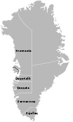
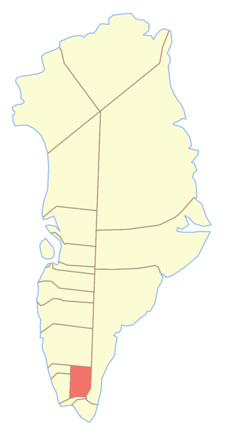
Kujalleq is a municipality on the southern tip of Greenland, operational from 1 January 2009. The administrative center of the municipality is in Qaqortoq.

Tunulliarfik Fjord

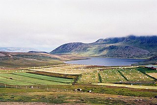
Tunulliarfik Fjord is a fjord near Qaqortoq in the Kujalleq municipality in southern Greenland. It is the inner section of Skovfjord (Skovfjorden). In times of the Norse settlement in southern Greenland, it was known as Eiriksfjord.

Narsaq Municipality

Narsaq Municipality was a municipality in south Greenland until 31 December 2008. The municipality consisted of Narsaq, and the settlements Qassiarsuk, Igaliku, and Narsarsuaq. Its administrative center was the town of Narsaq. It was incorporated into the new Kujalleq municipality on 1 January 2009, when the municipalities of Narsaq, Nanortalik, and Qaqortoq ceased to exist as administrative entities.

Qorlortorsuaq Dam

Qorlortorsuaq Dam is a hydroelectric dam near Qorlortorsuaq in the Nanortalik district of the Kujalleq municipality in southern Greenland. It has a capacity of 7.2 MW and it generates power for the neighbouring towns of Qaqortoq and Narsaq.

References

  1. "Kujalleq Municipality" (in Danish). Archived from the original on 2013-02-13. Retrieved 2010-04-28.
  2. "Population by Localities". Statistical Greenland.
  3. Orri Vésteinsson (January 2016). "Nomination to UNESCO's World Heritage List -- Kujataa: a subarctic farming landscape in Greenland". The Greenlandic Ministry of Education,Culture, Research and Church. Retrieved 30 July 2021.
  4. "Archaeological Excavations at Qassiarsuk 2005 – 2006" (PDF). Greenland National Museum. Retrieved June 4, 2012.
  5. "Narsaq Kommuneplan 2008-2018" (PDF). Retrieved June 4, 2012.
  6. "Road Construction in Greenland – the Greenlandic Case" (PDF). Archived from the original (PDF) on March 18, 2012. Retrieved June 4, 2012.
  7. "Narsaq Municipality". Archived from the original on March 17, 2012. Retrieved June 4, 2012.
  8. "About the Qassiarsuk area". Greenland Guide & Project Leif 2000. Archived from the original on August 6, 2017. Retrieved June 4, 2012.
  9. "Hiking tours in the Qassiarsuk area" (PDF). Blue Ice Explorer. Archived from the original (PDF) on December 27, 2013. Retrieved June 4, 2012.
  10. 1 2 "Statistics Greenland" (in Danish). Archived from the original on July 21, 2011.