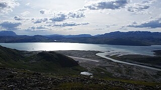
Narsarsuaq is a settlement in the Kujalleq municipality in southern Greenland. It had 123 inhabitants in 2020. There is a thriving tourism industry in and around Narsarsuaq, whose attractions include a great diversity of wildlife, gemstones, tours to glaciers, and an airfield museum.
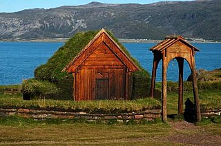
Brattahlíð, often anglicised as Brattahlid, was Erik the Red's estate in the Eastern Settlement Viking colony he established in south-western Greenland toward the end of the 10th century. The present settlement of Qassiarsuk, approximately 5 km (3.1 mi) southwest from the Narsarsuaq settlement, is now located in its place. The site is located about 96 km (60 mi) from the ocean, at the head of the Tunulliarfik Fjord, and hence sheltered from ocean storms. Erik and his descendants lived there until about the mid-15th century. The name Brattahlíð means "the steep slope". The estate, along with other archeological sites in southwestern Greenland, was inscribed on the UNESCO World Heritage List in 2017 as Kujataa Greenland: Norse and Inuit Farming at the Edge of the Ice Cap.

Narsaq is a town in the Kujalleq municipality in southern Greenland. The name Narsaq is Kalaallisut for "Plain", referring to the shore of Tunulliarfik Fjord where the town is located.

Qaqortoq, formerly Julianehåb, is a city in, and the capital of, the Kujalleq municipality in southern Greenland, located near Cape Thorvaldsen. With a population of 3,050 in 2020, it is the most populous town in southern Greenland and the fourth or fifth-largest town on the island.

Alluitsup Paa is a village in the Kujalleq municipality in southern Greenland. Alluitsup Paa had 202 residents in 2020. Presently, the community's religious activities take place in Qaqortoq.
Qassiarsuk is a settlement in the Kujalleq municipality, in southern Greenland. Its population was 39 in 2020. Qassiarsuk is part of the Kujataa World Heritage Site, due to its historical importance as the homestead of Erik the Red and its unique testimony to Greenlandic farming.

Tasiusaq is a settlement in the Kujalleq municipality in southern Greenland, founded in 1933. It is located at the Tasermiut Fjord, east of Nanortalik. Its population was 53 in 2020. In the Greenlandic language, the name of the settlement means "like a lake", referring to the lake-looking bay it situated on. The inhabitants call it "Tasiisaq", which is the local dialect.
Narsarmijit, formerly Narsaq Kujalleq and Frederiksdal, is a settlement in southern Greenland. It is located in the Kujalleq municipality near Cape Thorvaldsen. Its population was 66 in 2020. There has been a slow but steady pattern of emigration since the late 1950s.

Ammassivik is a settlement in the Kujalleq municipality in southern Greenland. The modern name is the Kalaallisut for "where you catch ammassaat (capelin)". Its population was 74 in 2010 and 32 in 2020.

Narsarsuaq Airport is an airport located in Narsarsuaq, a settlement in the Kujalleq municipality in southern Greenland. Along with Kangerlussuaq Airport, it is one of two airports in Greenland capable of serving large airliners. It is also the only international airport in southern Greenland. The settlement it serves is small, with the airport primarily functioning as a transfer point for passengers heading for the helicopter hubs of Air Greenland in Qaqortoq and Nanortalik. The airport is to be closed in 2025 when Qaqortoq Airport is scheduled to open.

Arsuk is a village in the Sermersooq municipality in southwestern Greenland. It had 73 inhabitants in 2020. The name of the settlement means the beloved place in the Greenlandic language. The village is served by the communal all-purpose Pilersuisoq store.

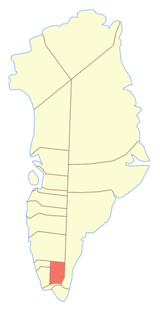
Kujalleq is a municipality on the southern tip of Greenland, operational from 1 January 2009. The administrative center of the municipality is in Qaqortoq.

Arctic Umiaq Line A/S (AUL) or Arctic Umiaq is a passenger and freight shipping line in Greenland. Its name derives from the Kalaallisut word for the traditional Inuit passenger boat, the umiak, distinguished from the kayak, used for hunting. The sea connection provided by Arctic Umiaq provides supplies and communication to the entirety of western and southwestern Greenland. It is a wholly owned subsidiary of the Royal Arctic Line.
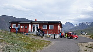
Narsaq Heliport is a heliport in the northwestern part of Narsaq, a town in the Kujalleq municipality, in southern Greenland.
Alanngorsuaq Fjord, also known as Coppermine Bay, is a fjord in the Kujalleq municipality in southern Greenland. At the mouth of the fjord the coastline of southwestern Greenland turns to the east towards Qaqortoq.
Narsaq Municipality was a municipality in south Greenland until 31 December 2008. The municipality consisted of Narsaq, and the settlements Qassiarsuk, Igaliku, and Narsarsuaq. Its administrative center was the town of Narsaq. It was incorporated into the new Kujalleq municipality on 1 January 2009, when the municipalities of Narsaq, Nanortalik, and Qaqortoq ceased to exist as administrative entities.
Amerloq Fjord is a 36 km (22 mi) long fjord in the Qeqqata municipality in western Greenland. The fjord empties into the Davis Strait just south of Sisimiut, whose former Inuit name was also "Amerloq".
Qorlortorsuaq Dam is a hydroelectric dam near Qorlortorsuaq in the Nanortalik district of the Kujalleq municipality in southern Greenland. It has a capacity of 7.6 MW and it generates power for the neighbouring towns of Qaqortoq and Narsaq.


