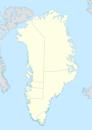
Greenland is a North American island autonomous territory of the Kingdom of Denmark. It is the larger of two autonomous territories within the Kingdom, the other being the Faroe Islands; the citizens of both territories are full citizens of Denmark. As Greenland is one of the Overseas Countries and Territories of the European Union, citizens of Greenland are European Union citizens. The capital and largest city of Greenland is Nuuk. Greenland lies between the Arctic and Atlantic oceans, east of the Canadian Arctic Archipelago. It is the world's largest island, and is the location of the northernmost point of land in the world – Kaffeklubben Island off the northern coast is the world's northernmost undisputed point of land, and Cape Morris Jesup on the mainland was thought to be so until the 1960s.

The history of Greenland is a history of life under extreme Arctic conditions: currently, an ice sheet covers about eighty percent of the island, restricting human activity largely to the coasts. The first humans are thought to have arrived in Greenland around 2500 BCE. Their descendants apparently died out and were succeeded by several other groups migrating from continental North America. There has been no evidence discovered that Greenland was known to Norsemen until the ninth century CE, when Norse Icelandic explorers settled on its southwestern coast. The ancestors of the Greenlandic Inuit who live there today appear to have migrated there later, around the year 1200, from northwestern Greenland.
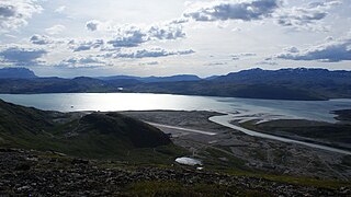
Narsarsuaq is a settlement in the Kujalleq municipality in southern Greenland. It had 123 inhabitants in 2020. There is a thriving tourism industry in and around Narsarsuaq, whose attractions include a great diversity of wildlife, gemstones, tours to glaciers, and an airfield museum.
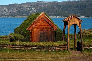
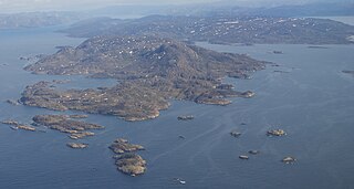
Brattahlíð, often anglicised as Brattahlid, was Erik the Red's estate in the Eastern Settlement Viking colony he established in south-western Greenland toward the end of the 10th century. The present settlement of Qassiarsuk, approximately 5 km (3.1 mi) southwest from the Narsarsuaq settlement, is now located in its place. The site is located about 96 km (60 mi) from the ocean, at the head of the Tunulliarfik Fjord, and hence sheltered from ocean storms. Erik and his descendants lived there until about the mid-15th century. The name Brattahlíð means "the steep slope". The estate, along with other archeological sites in southwestern Greenland, was inscribed on the UNESCO World Heritage List in 2017 as Kujataa Greenland: Norse and Inuit Farming at the Edge of the Ice Cap.

Narsaq is a town in the Kujalleq municipality in southern Greenland. The name Narsaq is Kalaallisut for "Plain", referring to the shore of Tunulliarfik Fjord where the town is located.

Nanortalik, formerly Nennortalik, is a town in Nanortalik Island, Kujalleq municipality, southern Greenland. With 1,185 inhabitants as of 2020, it is the eleventh-largest town in the country. The name Nanortalik means "Place of Polar Bears" or "Place Where the Polar Bears Go". It is the southernmost town in Greenland with a population of over 1,000.

Qaqortoq, formerly Julianehåb, is a city in, and the capital of, the Kujalleq municipality in southern Greenland, located near Cape Thorvaldsen. With a population of 3,050 in 2020, it is the most populous town in southern Greenland and the fourth or fifth-largest town on the island.

Alluitsup Paa is a village in the Kujalleq municipality in southern Greenland. Alluitsup Paa had 202 residents in 2020. Presently, the community's religious activities take place in Qaqortoq.
Qassiarsuk is a settlement in the Kujalleq municipality, in southern Greenland. Its population was 39 in 2020. Qassiarsuk is part of the Kujataa World Heritage Site, due to its historical importance as the homestead of Erik the Red and its unique testimony to Greenlandic farming.
Sarfannguit is a settlement in the Qeqqata municipality in central-western Greenland. Its population was 96 in 2020. The settlement was founded in 1843. The town is located within the Aasivissuit – Nipisat UNESCO World Heritage Site, and is inscribed on the World Heritage List in 2018 for its outstanding archeological sites representing the human occupation of Greenland for over 4,000 years.

Hvalsey is located near Qaqortoq, Greenland and is the site of Greenland's largest, best-preserved Norse ruins in the area known as the Eastern Settlement (Eystribyggð). In 2017, it was inscribed on the UNESCO World Heritage List and part of the Kujataa Greenland site.
Garðar was the seat of the bishop in the Norse settlements in Greenland. It is a Latin Catholic titular see, and was the first Catholic diocese established in the Americas.
The Eastern Settlement was the first and by far the larger of the two main areas of Norse Greenland, settled c. AD 985 – c. AD 1000 by Norsemen from Iceland. At its peak, it contained approximately 4,000 inhabitants. The last written record from the Eastern Settlement is of a wedding in Hvalsey in 1408, placing it about 50–100 years later than the end of the more northerly Western Settlement.
The Western Settlement was a group of farms and communities established by Norsemen from Iceland around 985 in medieval Greenland. Despite its name, the Western Settlement was more north than west of its companion Eastern Settlement and was located at the bottom of the deep Nuup Kangerlua fjord.
Tourism in Greenland is a relatively young business area of the country. Since the foundation of the national tourist council, Greenland Tourism, in 1992, the Home Rule Government has been working actively with promoting the destination and helping smaller tourist providers to establish their services. Foreign travel agencies have increasingly been opening up sale of Greenland trips and tours, and the cruise industry has had a relatively large increase in routes to Greenland since about the turn of the century.

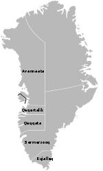
Kujalleq is a municipality on the southern tip of Greenland, operational from 1 January 2009. The administrative center of the municipality is in Qaqortoq.
Hvalsey Church was a Catholic church in the abandoned Greenlandic Norse settlement of Hvalsey. The best preserved Norse ruins in Greenland, the church was also the location of the last written record of the Greenlandic Norse, a wedding in September 1408.
The majority of the Greenlandic population is Christian and associates with the Church of Denmark via the Church of Greenland, which is Protestant in classification and Lutheran in orientation. The Church of Denmark is the established church through the Constitution of Denmark; this applies to all of the Kingdom of Denmark, except for the Faroe Islands, as the Church of the Faroe Islands became independent in 2007. But traditional Inuit spiritual beliefs remain strong in many of Greenland's remote communities.

Vatnahverfi was a district in the Norse Greenlanders’ Eastern Settlement (Eystribyggð) and is generally regarded by archaeologists and historians as having the best pastoral land in the colony. The Norse settled Vatnahverfi in the late 10th century and farmed there for nearly 500 years before mysteriously disappearing from the district and the entirety of Greenland, likely at some point in the latter 15th century. Its name is roughly translated as “Lake District."

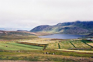
Kujataa is a sub-arctic farming landscape in the southern region of Greenland. It is the first known example of agriculture in the Arctic, and the oldest evidence of the Old Norse culture spreading outside Europe. The unique juxtaposition of farming and hunting for marine mammals that occurred in the region from the 10th through 15th centuries and from the 18th century to today headlined the region's inscription on the UNESCO World Heritage List in 2017.