
The history of Greenland is a history of life under extreme Arctic conditions: currently, an ice sheet covers about eighty percent of the island, restricting human activity largely to the coasts. The first humans are thought to have arrived in Greenland around 2500 BCE. Their descendants most likely died out and were replaced and succeeded by several other human groups migrating from continental North America since then. There has been no evidence discovered that Greenland was known to Norsemen until the ninth century CE, when Norse Icelandic explorers settled on its southwestern coast. The ancestors of the Greenlandic Inuit who live there today appear to have migrated there later, around the year 1200, from northwestern Greenland.
The Thule or proto-Inuit were the ancestors of all modern Inuit. They developed in coastal Alaska by 1000 AD and expanded eastward across northern Canada, reaching Greenland by the 13th century. In the process, they replaced people of the earlier Dorset culture who had previously inhabited the region. The appellation "Thule" originates from the location of Thule in northwest Greenland, facing Canada, where the archaeological remains of the people were first found at Comer's Midden.
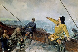
The exploration of North America by Norsemen began in the late 10th century when they explored areas of the North Atlantic, colonized Greenland, and created a short-term settlement near the northern tip of Newfoundland. The remains of buildings were found at L'Anse aux Meadows in 1960 dating to approximately 1,000 years ago. This discovery helped reignite archaeological exploration for the Norse in the North Atlantic. This single settlement, located on the island of Newfoundland and not on the North American mainland, was abruptly abandoned.
Skræling is the name the Norse Greenlanders used for the peoples they encountered in North America. In surviving sources, it is first applied to the Thule people, the proto-Inuit group with whom the Norse coexisted in Greenland after about the 13th century. In the sagas, it is also used for the peoples of the region known as Vinland whom the Norse encountered and fought during their expeditions there in the early 11th century.
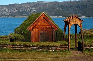
Brattahlíð, often anglicised as Brattahlid, was Erik the Red's estate in the Eastern Settlement Viking colony he established in south-western Greenland toward the end of the 10th century. The present settlement of Qassiarsuk, approximately 5 km (3.1 mi) southwest from the Narsarsuaq settlement, is now located in its place. The site is located about 96 km (60 mi) from the ocean, at the head of the Tunulliarfik Fjord, and hence sheltered from ocean storms. Erik and his descendants lived there until about the mid-15th century. The name Brattahlíð means "the steep slope". The estate, along with other archeological sites in southwestern Greenland, was inscribed on the UNESCO World Heritage List in 2017 as Kujataa Greenland: Norse and Inuit Farming at the Edge of the Ice Cap.
The culture of Greenland has much in common with Greenlandic Inuit tradition, as the majority of people are descended from Inuit. Many people still go ice fishing and there are annual dog-sled races in which everyone with a team participates.

Narsaq is a town in the Kujalleq municipality in southern Greenland. The name Narsaq is Kalaallisut for "Plain", referring to the shore of Tunulliarfik Fjord where the town is located.
Qassiarsuk is a settlement in the Kujalleq municipality, in southern Greenland. Its population was 39 in 2020. Qassiarsuk is part of the Kujataa World Heritage Site, due to its historical importance as the homestead of Erik the Red and its unique testimony to Greenlandic farming.
Igaliku is a settlement in the Kujalleq municipality in southern Greenland. The town was founded as Igaliko in 1783 by the trader and colonial administrator Anders Olsen and Greenlandic wife Tuperna. In 2020, Igaliku had 21 inhabitants. The nearby Norse ruins of Garðar and the farms surrounding the town were inscribed on the UNESCO World Heritage List in 2017 as part of the Kujataa Greenland: Norse and Inuit Farming at the Edge of the Ice Cap site.

Greenlanders, also called Greenlandics or Greenlandic people, are an Inuit ethnic group native to Greenland. They speak Greenlandic, an Eskaleut language.

Hvalsey is located near Qaqortoq, Greenland and is the site of Greenland's largest, best-preserved Norse ruins in the area known as the Eastern Settlement (Eystribyggð). In 2017, it was inscribed on the UNESCO World Heritage List and part of the Kujataa Greenland site.
The Eastern Settlement was the first and by far the larger of the two main areas of Norse Greenland, settled c. AD 985 – c. AD 1000 by Norsemen from Iceland. At its peak, it contained approximately 4,000 inhabitants. The last written record from the Eastern Settlement is of a wedding in Hvalsey in 1408, placing it about 50–100 years later than the end of the more northerly Western Settlement.

The Inughuit, or the Smith Sound Inuit, historically Arctic Highlanders or Polar Eskimos, are an ethnic subgroup of the Greenlandic Inuit. They are the northernmost group of Inuit and the northernmost people in North America, living in Greenland. Inughuit make up about 1% of the population of Greenland.

The Greenlandic Inuit are the indigenous and most populous ethnic group in Greenland. Most speak Greenlandic and consider themselves ethnically Greenlandic. People of Greenland are both citizens of Denmark and citizens of the European Union.
Nipisat Island is a small, uninhabited island in the Qeqqata municipality in central-western Greenland.

Norse settlements in Greenland were established after 986 by settlers coming from Iceland. The settlers, known as Grænlendingar, were the first Europeans to explore and temporarily settle North America. It is assumed that they developed their own language that is referred to as Greenlandic Norse, not to be confused with the Eskaleut Greenlandic language. Their settlements existed for about half a millennium before they were abandoned for reasons that are still not entirely clear.

Herjolfsnes was a Norse settlement in Greenland, 50 km northwest of Cape Farewell. It was established by Herjolf Bardsson in the late 10th century and is believed to have lasted some 500 years. The fate of its inhabitants, along with all the other Norse Greenlanders, is unknown. The site is known today for having yielded remarkably well-preserved medieval garments, excavated by Danish archaeologist Poul Nørlund in 1921. Its name roughly translates as Herjolf's Point or Cape.

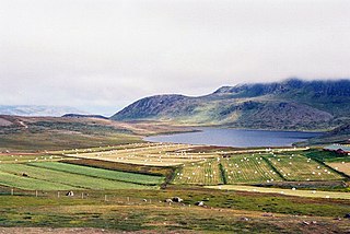
Vatnahverfi was a district in the Norse Greenlanders’ Eastern Settlement (Eystribyggð) and is generally regarded by archaeologists and historians as having the best pastoral land in the colony. The Norse settled Vatnahverfi in the late 10th century and farmed there for nearly 500 years before mysteriously disappearing from the district and the entirety of Greenland, likely at some point in the latter 15th century. Its name is roughly translated as “Lake District."
Aasivissuit – Nipisat: Inuit Hunting Ground between Ice and Sea is a cultural landscape and UNESCO World Heritage Site located in the central part of Western Greenland. Added to the World Heritage List in 2018, the site preserves the archeological remains of over 4000 years of occupation and contains well-preserved evidence of seasonal hunting and gathering. Remains from the Saqqaq, Dorset, and Thule cultures and sites from the later Inuit and colonial era are protected within the site.


