Narsarmijit Frederiksthal [1] | |
|---|---|
 View of the settlement | |
 Narsarmijit Location in Greenland | |
| Coordinates: 60°00′17″N44°39′55″W / 60.00472°N 44.66528°W | |
| State | |
| Constituent country | |
| Municipality | |
| Government | |
| • Mayor | Augo Simonsen |
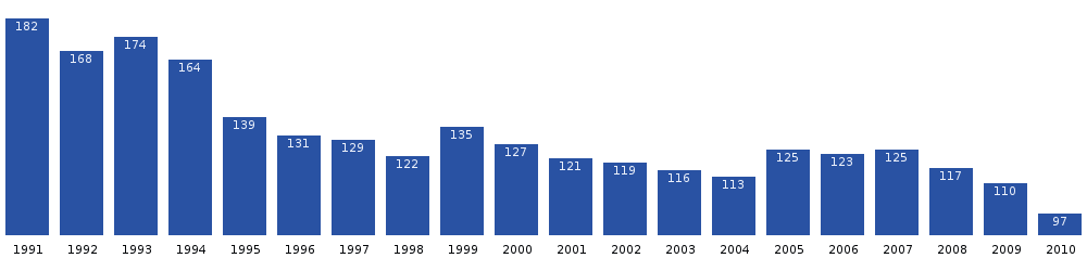
| Population (2025) | |
• Total | 55 |
| Time zone | UTC−02:00 (WGT) |
| • Summer (DST) | UTC−01:00 (WGST) |
| Postal code | 3922 Nanortalik |
Narsarmijit, [3] [4] formerly Narsaq Kujalleq and Frederiksdal (Anglicised: Frederiksthal), is a settlement in southern Greenland. It is located in the Kujalleq municipality near Cape Thorvaldsen. Its population was 62 in 2024. [5] There has been a slow but steady pattern of emigration since the late 1950s.