A hydrographic office is an organization which is devoted to acquiring and publishing hydrographic information.

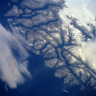
Baffin Bay, located between Baffin Island and the west coast of Greenland, is defined by the International Hydrographic Organization as a marginal sea of the Arctic Ocean. It is sometimes considered a sea of the North Atlantic Ocean. It is connected to the Atlantic via Davis Strait and the Labrador Sea. The narrower Nares Strait connects Baffin Bay with the Arctic Ocean. The bay is not navigable most of the year because of the ice cover and high density of floating ice and icebergs in the open areas. However, a polynya of about 80,000 km2 (31,000 sq mi), known as the North Water, opens in summer on the north near Smith Sound. Most of the aquatic life of the bay is concentrated near that region.

The Gulf of Alaska is an arm of the Pacific Ocean defined by the curve of the southern coast of Alaska, stretching from the Alaska Peninsula and Kodiak Island in the west to the Alexander Archipelago in the east, where Glacier Bay and the Inside Passage are found.

Kennedy Channel is an Arctic sea passage between Greenland and Canada's most northerly island, Ellesmere Island.

Kane Basin is an Arctic waterway lying between Greenland and Canada's northernmost island, Ellesmere Island. It links Smith Sound to Kennedy Channel and forms part of Nares Strait. It is approximately 180 kilometres in length and 130 km at its widest.
Wolstenholme Fjord is a fjord in Avannaata municipality, Northwest Greenland. It is located to the north of the Thule Air Base and adjacent to the abandoned Inuit settlement of Narsaarsuk.
Sammisoq is an island in the Kujalleq municipality in southern Greenland, located northeast of Uummannarsuaq cape. It is the largest island of the Cape Farewell Archipelago.

The Kumai River is a river of Central Kalimantan province, Borneo island, Indonesia.
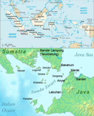
Tabuan Island is an island of southern Sumatra, under the jurisdiction of Lampung province. It is administered as part of the Cukuh Balak district of Tanggamus Regency.
The Shag Islands are a small group of islands in the southern part of Coppett Harbour, off the south coast of Newfoundland, Canada. They lie to the east of Bonalds Island. The southernmost island, Shag Island, is described as "a conspicuous white rock, 12.8m high".
Morskaya Matuga, also Ostrovok Morskaya Matuga or Motuga, is an islet in the Sea of Okhotsk, roughly 9 miles northeastward of the northern Khalpili Islet. It is described as "a precipitous flat-topped islet".

Crown Prince Christian Land is a large peninsula in northern Greenland. It is a part of King Frederick VIII Land and administratively it belongs to the Northeast Greenland National Park.

Cape Farewell Archipelago is an island group located at the southern end of Greenland in Kujalleq municipality. The archipelago takes its name from Cape Farewell, a headland of Egger Island.
Avallersuaq, old spelling Avatdlerssuaq, is an uninhabited island of the Cape Farewell Archipelago in Kujalleq municipality of southern Greenland.
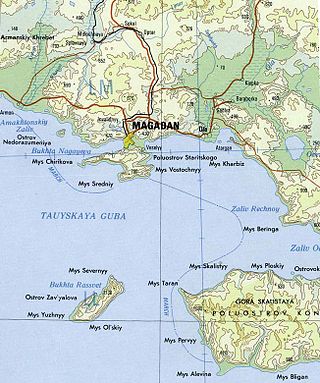
Nagaev Bay or Nagayev Bay, also known as Nagayeva Bay, is a bay within Taui Bay in the northern part of the Sea of Okhotsk, Magadan Oblast, Russia.
Peabody Bay is a large bay in northwestern Greenland. Administratively it is part of Avannaata municipality.
Kitsissut is an island group in the Kujalleq municipality in southern Greenland.
Cape Nansen is a headland in the Greenland Sea, east Greenland, Sermersooq municipality. This cape is named after Fridtjof Nansen. Cape Nansen is an important geographical landmark.
Castle Island is an island in far northern Greenland. Administratively it is part of the Northeast Greenland National Park.
Kjerulf Fjord is a fjord in King Christian X Land, eastern Greenland.


