This page is based on this
Wikipedia article Text is available under the
CC BY-SA 4.0 license; additional terms may apply.
Images, videos and audio are available under their respective licenses.

Greenland is located between the Arctic Ocean and the North Atlantic Ocean, northeast of Canada and northwest of Iceland. The territory comprises the island of Greenland–the largest island in the world–and more than a hundred other smaller islands. As an island, Greenland has no land boundaries and 44,087 km of coastline. A sparse population is confined to small settlements along certain sectors of the coast. Greenland possesses the world's second largest ice sheet.

Uummannaq is a town in the Avannaata municipality, in central-western Greenland. With 1,282 inhabitants in 2013, it is the eleventh-largest town in Greenland, and is home to the country's most northerly ferry terminal. Founded in 1763 as Omenak, the town is a hunting and fishing base, with a canning factory and a marble quarry. In 1932 the Universal Greenland-Filmexpedition with director Arnold Fanck realized the film SOS Eisberg near Uummannaq.

Lincoln Sea is a body of water in the Arctic Ocean, stretching from Cape Columbia, Canada, in the west to Cape Morris Jesup, Greenland, in the east. The northern limit is defined as the great circle line between those two headlands. It is covered with sea ice throughout the year, the thickest sea ice in the Arctic Ocean, which can be up to 15 m (49 ft) thick. Water depths range from 100 m (330 ft) to 300 m (980 ft). Water and ice from Lincoln Sea empty into Robeson Channel, the northernmost part of Nares Strait, most of the time.

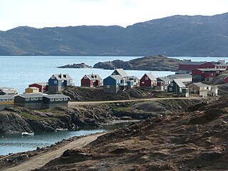
Nanortalik, formerly Nennortalik, is a town in Nanortalik Island, Kujalleq municipality, southern Greenland. With 1,337 inhabitants as of 2013, it is the tenth-largest town in the country. The name Nanortalik means "Place of Polar Bears" or "Place Where the Polar Bears Go". It is the southernmost town in Greenland, with a population of over 1,000.

Aappilattoq is a village in the Kujalleq municipality in southern Greenland. The name means "red", after the red mountain rising above the settlement in the Greenlandic language. The settlement had 132 inhabitants in 2010.

Narsarmijit, also known as Narsaq Kujalleq, formerly Frederiksdal, is a settlement in southern Greenland. It is located in the Kujalleq municipality near Cape Thorvaldsen. Its population was 88 in 2016. There has been a slow but steady pattern of emigration since the late 1950s.
Sammisoq is an island in the Kujalleq municipality in southern Greenland, located northeast of Uummannarsuaq cape. It is the largest island of the Cape Farewell Archipelago.
A headland is a coastal landform, a point of land usually high and often with a sheer drop, that extends into a body of water. It is a type of promontory. A headland of considerable size often is called a cape. Headlands are characterised by high, breaking waves, rocky shores, intense erosion, and steep sea cliffs.

Kujalleq is a municipality on the southern tip of Greenland, operational from 1 January 2009. The administrative center of the municipality is in Qaqortoq. The municipality consists of the former municipalities of southern Greenland, each named after the biggest settlement:
The Irminger Sea is a marginal sea of the North Atlantic Ocean.
Alluitsoq is the name of a former settlement in southern Greenland, located on the Alluitsoq or Lichtenau Fjord near Cape Farewell. It is about 7 kilometers from Ammassivik (Sletten), located on the opposite side of the same fjord.

Cape Farewell Archipelago is an island group located at the southern end of Greenland in Kujalleq municipality. The archipelago takes its name from Cape Farewell, a headland of Egger Island.

Tunumiit are Greenlandic Inuit from Tunu, the eastern part of Greenland. The Tunummiit live now mainly in Tasiilaq and Ittoqqortoormiit and are a part of the Arctic people known collectively as the Inuit. The singular for Tunumiit is Tunumiu.
Herjolfsnes was a Norse settlement in Greenland, about 50 km northwest of Cape Farewell. It was established by Herjolf Bardsson in the late 10th century and is believed to have lasted about 500 years. The fate of its inhabitants, along with all the other Norse Greenlanders, is unknown. The site is known today for having yielded remarkably well-preserved medieval garments, excavated by Danish archaeologist Paul Norland in 1921. Its name roughly translates as Herjolf's Point or Cape.
Kitsissut is an island group in the Kujalleq municipality in southern Greenland.
Nanuuseq, also known as Nanûseq or Nanusek is an uninhabited island in the Kujalleq municipality in southern Greenland.

King Frederick VI Coast is a major geographic division of Greenland. It comprises the coastal area of Southeastern Greenland in Sermersooq and Kujalleq municipalities fronting the Irminger Sea of the North Atlantic Ocean. It is bordered by King Christian IX Land on the north and the Greenland Ice Sheet to the west.

Egger Island is Greenland's southernmost island. It is located in the Kujalleq municipality and is uninhabited.
