
The Eureka Rebellion was a series of events involving gold miners who revolted against the British administration of the colony of Victoria, Australia during the Victorian gold rush. It culminated in the Battle of the Eureka Stockade, which took place on 3 December 1854 at Ballarat between the rebels and the colonial forces of Australia. The fighting resulted in an official total of 27 deaths and many injuries, the majority of casualties being rebels. There was a preceding period beginning in 1851 of peaceful demonstrations and civil disobedience on the Victorian goldfields. The miners had various grievances, chiefly the cost of mining permits and the officious way the system was enforced.

Ellesmere Island is Canada's northernmost and third largest island, and the tenth largest in the world. It comprises an area of 196,236 km2 (75,767 sq mi), slightly smaller than Great Britain, and the total length of the island is 830 km (520 mi).
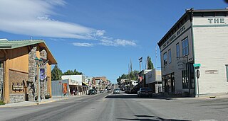
Eureka is a town in Lincoln County, Montana, United States, 9 miles (14 km) south of the Canada–US border. The population was 1,380 at the 2020 census.

Eureka is a small research base on Fosheim Peninsula, Ellesmere Island, Qikiqtaaluk Region, in the Canadian territory of Nunavut. It is located on the north side of Slidre Fiord, which enters Eureka Sound farther west. It is the third-northernmost permanent research community in the world. The only two farther north are Alert, which is also on Ellesmere Island, and Nord, in Greenland. Eureka has the lowest average annual temperature and the lowest amount of precipitation of any weather station in Canada.

Eureka Aerodrome is located at Eureka, Nunavut, Canada, and is operated by Environment Canada.

Oliver Perry Hay was an American herpetologist, ichthyologist, and paleontologist.
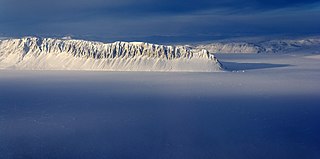
The Sawtooth Range is a jagged snow-capped mountain range on central Ellesmere Island, Nunavut, Canada. It lies between the Fosheim Peninsula and the Wolf Valley. The Sawtooth Range is a subrange of the Arctic Cordillera. It also runs through a Canadian Forces Station, called Eureka, a base used to study atmospheric changes.
Prospect Glacier is a glacier between Kinnear Mountains and Mayer Hills, flowing north into Forster Ice Piedmont on the west coast of Antarctic Peninsula. It was first roughly surveyed in 1936 by the British Graham Land Expedition (BGLE) under Rymill. In 1954 the United Kingdom Antarctic Place-Names Committee (UK-APC) gave the name Prospect Pass to a col between Eureka Glacier and the glacier here described. During resurvey of the area by the Falkland Islands Dependencies Survey (FIDS) in 1958, the col was found to be an indeterminate feature, while this glacier is well marked and requires a name.
Stor Island is one of the uninhabited islands in Qikiqtaaluk Region, Nunavut, Canada. It is located in Eureka Sound, an area separating Axel Heiberg Island from Ellesmere Island. Fulmar Channel is southwest of the island, while Bay Fiord is to the northeast. Stor Island is a member of the Sverdrup Islands, Queen Elizabeth Islands, and the Arctic Archipelago.
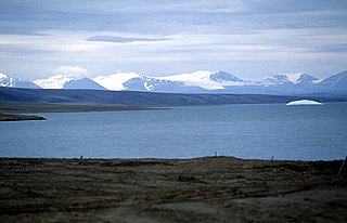
Eureka Sound is a high Arctic waterway in Qikiqtaaluk, Nunavut, Canada. It separates Axel Heiberg Island from Ellesmere Island. Stor Island is located within the sound. Eureka Sound is 290 km (180 mi) long, and 13–48 km (8.1–29.8 mi) wide. Fort Eureka is nearby.
The Buninyong Line was a Victorian Railways (Australia) branch line, which ran south from Ballarat to the nearby town of Buninyong. The line branched from the main Melbourne – Ballarat railway at Ballarat East station and was 11 km long. The line was opened on 11 September 1889, with traffic commencing the following day.
The Fosheim Peninsula is located in western Ellesmere Island, a part of the Qikiqtaaluk Region of the Canadian territory of Nunavut. Eureka, a permanent research community, is located on the north side of Slidre Fiord, a few kilometers east of Eureka Sound. While the peninsula was first sighted by the Arctic explorer Adolphus Greely in 1881, it was not explored until 1899 by Otto Sverdrup, who named it after Ivar Fosheim, a member of his expedition.
Eureka Dome is a mountain in the Ogilvie Mountains of Yukon, Canada. The trail for the Yukon Quest 1,000-mile sled dog race passes over the mountain every February.
Irene Bay is an Arctic waterway in the Qikiqtaaluk Region. Nunavut, Canada. It is located in Eureka Sound by western Ellesmere Island.
The Gretha Islands are an uninhabited island group located in the Qikiqtaaluk Region of Nunavut, Canada. They are situated in Eureka Sound at the confluence of Bay Fjord, north of Ellesmere Island's Raanes Peninsula, and east of Stor Island. They are members of the Sverdrup Islands group, Queen Elizabeth Islands, and the Arctic Archipelago.
Hat Island is an uninhabited island located in the Qikiqtaaluk Region of Nunavut, Canada. It is situated in Eureka Sound, at the confluence of Bay Fjord, east of Ellesmere Island's Raanes Peninsula and 19.6 km (12.2 mi) west of Stor Island. It is a member of the Sverdrup Islands group and the Arctic Archipelago. It is also a member of the Queen Elizabeth Islands and the Arctic Archipelago.

The electoral district of Buninyong was an electoral district of the Victorian Legislative Assembly in Australia. It was created in the redistribution of electoral boundaries in 2013, and came into effect at the 2014 state election.

Proposition 54 is a California ballot proposition that passed on the November 8, 2016 ballot. It requires the recording and posting of videos of public meetings of the State Legislature. The measure requires the recordings to be posted on the internet within 24 hours of a meeting, available online for at least 72 hours before a bill can be passed, and downloadable for at least 20 years. The measure also allows members of the public to record meetings.

The Electoral district of Eureka is an electoral district of the Victorian Legislative Assembly in Australia. It was created in the redistribution of electoral boundaries in 2021, and came into effect at the 2022 Victorian state election.
