
Ellesmere Island is Canada's northernmost and third largest island, and the tenth largest in the world. It comprises an area of 196,236 km2 (75,767 sq mi), slightly smaller than Great Britain, and the total length of the island is 830 km (520 mi).
Quttinirpaaq National Park is located on the northeastern corner of Ellesmere Island in the Qikiqtaaluk Region of Nunavut, Canada. It is the second most northerly park on Earth after Northeast Greenland National Park. In Inuktitut, Quttinirpaaq means "top of the world". It was established as Ellesmere Island National Park Reserve in 1988, and the name was changed to Quttinirpaaq in 1999, when Nunavut was created, and became a national park in 2000. The reserve covers 37,775 km2 (14,585 sq mi), making it the second largest park in Canada, after Wood Buffalo National Park.
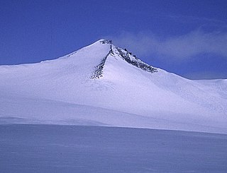
Barbeau Peak is a mountain in Qikiqtaaluk, Nunavut, Canada. Located on Ellesmere Island within Quttinirpaaq National Park, it is the highest mountain in Nunavut and the Canadian Arctic. The mountain was named in 1969 after Marius Barbeau, a Canadian anthropologist whose research into First Nations and Inuit cultures gained him international acclaim.

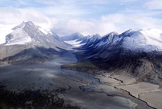
The British Empire Range is a mountain range on Ellesmere Island in Nunavut, Canada. The range is one of the most northern ranges in the world and the Arctic Cordillera, surpassed only by the Challenger Mountains which lies immediately to the northwest and the United States Range slightly further east. The highest mountain in the range is Barbeau Peak.
Mount Eugene is the highest mountain of the United States Range on Ellesmere Island. Originally named "Mount Arthur Eugene" in 1883 by the States Army Signal Service during their Lady Franklin Bay expedition.
Mount Whisler is a mountain of the British Empire Range on Canada's Ellesmere Island. It is the second highest peak of the British Empire Range, of Ellesmere Island, and of the Arctic Cordillera. It is located about 12 km (7.5 mi) northeast of Barbeau Peak, the highest peak in the Cordillera. The Henrietta Nesmith Glacier completely surrounds Mount Whisler.
Mount Oxford is located on Ellesmere Island, Nunavut, Canada and was named for the University of Oxford. The first known ascent was in 1935 by A. W. Moore and Nukapinguaq, a Greenland Inuit, during the Oxford University Ellesmere Land Expedition, when Moore estimated the height as 9,000 ft (2,743 m).
Arrowhead Mountain is a mountain located on Ellesmere Island, Nunavut, Canada and is located east northeast of Mount Oxford. The mountain was named due to the four ridges that rise to a peak.
Mount Arthur is a mountain located on Ellesmere Island, Nunavut, Canada in the Quttinirpaaq National Park. First mapped by the Lady Franklin Bay Expedition, it was named for Chester A. Arthur the 21st President of the United States.
Mount Beaufort is a mountain located on Ellesmere Island, Nunavut, Canada and was named after Francis Beaufort. The mountain was first sighted by Elisha Kane in 1845 and named Mount Francis Beaufort.

The Arctic Cordillera is a terrestrial ecozone in northern Canada characterized by a vast, deeply dissected chain of mountain ranges extending along the northeastern flank of the Canadian Arctic Archipelago from Ellesmere Island to the northeasternmost part of the Labrador Peninsula in northern Labrador and northern Quebec, Canada. It spans most of the eastern coast of Nunavut with high glaciated peaks rising through ice fields and some of Canada's largest ice caps, including the Penny Ice Cap on Baffin Island. It is bounded to the east by Baffin Bay, Davis Strait and the Labrador Sea while its northern portion is bounded by the Arctic Ocean.

The Ayles Ice Shelf was one of six major ice shelves in Canada, all on the north coast of Ellesmere Island, Nunavut. The ice shelf broke off from the coast on August 13, 2005, forming a giant ice island 37 m (121 ft) thick and measuring around 14 by 5 km in size. The oldest ice in the ice shelf is believed to be over 3,000 years old. The ice shelf was at, approximately 800 km (500 mi) south of the North Pole.

The British Arctic Expedition of 1875–1876, led by Sir George Nares, was sent by the British Admiralty to attempt to reach the North Pole via Smith Sound on the west coast of Greenland.

Mount Odin is a mountain in Qikiqtaaluk, Nunavut, Canada. It is located in Auyuittuq National Park along the Akshayuk Pass, 46 km (29 mi) north of Pangnirtung and south of Mount Asgard. Mount Odin is the highest mountain on Baffin Island.
Commonwealth Mountain is a mountain on Ellesmere Island, Nunavut, Canada. It lies in western Quttinirpaaq National Park, which is the most northerly extent of Canada, and is the second most northerly park on Earth after Northeast Greenland National Park.

The Conger Range, also called the Conger Mountains, is a mountain range in Quttinirpaaq National Park on Ellesmere Island, Nunavut, Canada, beginning about 16 km (10 mi) west of Mount Osborne. It is part of the Arctic Cordillera which is a vast dissected mountain system extending from Ellesmere Island to the northernmost tip of Labrador and northeastern Quebec. The Conger Range is a structural extension of the Garfield Range and continues into the highlands north of the head of Hare Fiord. The overall extent of the range is about 180 km (112 mi). Most of its peaks are ice-covered, although nearly all of the southern slopes are ice-free. Many of the valleys between the peaks are filled with glacial tongues spilling out to the south from the Grand Land Ice Cap. Its highest point is Mount Biederbick at 1,542 m (5,059 ft).

Ward Hunt Island is a small, uninhabited island in the Arctic Ocean, located off the north coast of Ellesmere Island near the Ward Hunt Ice Shelf. The island is located just 750 km (470 mi) from the geographical North Pole. The northern cape of Ward Hunt Island is one of the northernmost elements of land in Canada. Only a 17 km (11 mi) stretch of northern coast of Ellesmere Island around Cape Columbia is more northerly. The island is 5.0 km (3.1 mi) long, east to west, and 3.0 km (1.9 mi) wide. The first known sighting was in 1876 by Pelham Aldrich, a lieutenant with the George Nares expedition, and named for George Ward Hunt, who was First Lord of the Admiralty at the time (1874–1877). Today, the Island is part of the Quttinirpaaq National Park.
The Ellesmere Ice Shelf was the largest ice shelf in the Arctic, encompassing about 9,100 square kilometres of the north coast of Ellesmere Island, Nunavut, Canada. The ice shelf was first documented by the British Arctic Expedition of 1875–76, in which Lieutenant Pelham Aldrich's party went from Cape Sheridan to Cape Alert. The continuous mass of the Ellesmere Ice Shelf had been in place for at least 3,000 years.
HMS Alert was a 17-gun wooden screw sloop of the Cruizer class of the Royal Navy, launched in 1856 and broken up in 1894. She was the eleventh ship of the Royal Navy to bear the name, and was noted for her Arctic exploration work; in 1876 she reached a record latitude of 82° North. Alert briefly served with the US Navy, and ended her career with the Canadian Marine Service as a lighthouse tender and buoy ship.
