
The Piegan are an Algonquian-speaking people from the North American Great Plains. They are the largest of three Blackfoot-speaking groups that make up the Blackfoot Confederacy; the Siksika and Kainai are the others. The Piegan dominated much of the northern Great Plains during the nineteenth century.

The Bare Range is a mountain range of the Canadian Rockies, located south of the Red Deer River valley in Banff National Park, Canada. The range is named for the "bareness" of or lack of trees on the gentle slopes of the range.

The Beaverfoot Range is a mountain range in the Kootenay Ranges of the Canadian Rockies, located in southeastern British Columbia. The range extends from Cedared Creek near Spillimacheen north to the Kicking Horse River.

The Palliser Range is a mountain range of the Canadian Rockies that lies in the extreme southeast corner of Banff National Park, Alberta, Canada.

The Massive Range is a mountain range of the Canadian Rockies, located in the southwestern area of the Bow River valley in Banff National Park, Canada.
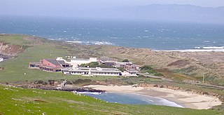
The University of California Natural Reserve System (UCNRS) is a system of protected areas throughout California. The reserves support UC's mission of teaching, research, and public service. Unlike national and state parks, they are not available for recreational uses, because they were specifically created to enable UC scientists to conduct research free from such distractions.
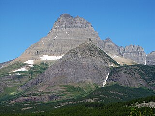
Mount Wilbur is located in the Lewis Range, Glacier National Park in the U.S. state of Montana. Plainly visible from the region of Many Glacier, the peak rises over 4,500 feet (1,372 m) above Swiftcurrent Lake and is a steep pyramid on three sides. The west slopes of the peak join to ridges along the continental divide. Much of the climbing routes are rated at class 4 to 5, with some only used once. The sedimentary rock of the mountains makes for often poor anchoring points and enhances the difficulty. A cirque on the north slopes of the mountain shelters Iceberg Lake, a popular hiking destination from Many Glacier. The mountain was named by George Bird Grinnell in 1885, for Edward R. Wilbur of New York, one of Grinnell's partners in the Forest and Stream Publishing Company, and both men were founders of the Audubon Society.

Joseph P. Grinnell was an American field biologist and zoologist. He made extensive studies of the fauna of California, and is credited with introducing a method of recording precise field observations known as the Grinnell System. He served as the first director of the Museum of Vertebrate Zoology at the University of California, Berkeley from the museum's inception in 1908 until his death.

Crowsnest Range is a mountain range of the Rocky Mountains in southwestern Alberta and southeastern British Columbia, Canada.
Grinnell Peninsula is a peninsula of northwestern Devon Island in Nunavut, Canada.
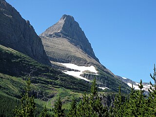
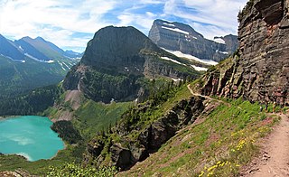
Mount Grinnell is a peak located in the heart of Glacier National Park in the U.S. state of Montana. Lying just east of the Continental Divide in the Many Glacier region of the park, the peak is flanked to the northwest by Swiftcurrent Glacier and to the south by Grinnell Glacier. Mount Grinnell is named after George Bird Grinnell. From the Many Glacier Hotel on Swiftcurrent Lake, the eastern arm of Mount Grinnell, known as Grinnell Point, hides the main summit.
Allen Island is an uninhabited island in the Qikiqtaaluk Region of Nunavut, Canada. It is a Baffin Island offshore island located in Cornelius Grinnell Bay. It is east of Hall Peninsula and is separated from Beekman Peninsula on the west by Smith Channel. The significantly smaller Rogers Island is approximately 13 km (8.1 mi) to the south.
Saglaarjuk formerly Amherst Island is one of several uninhabited, irregularly shaped islands located on the south side of the Fury and Hecla Strait of Nunavut's Qikiqtaaluk Region within the northern Canadian Arctic. It is west of Liddon Island, north of Grinnell Lake on the mainland's Melville Peninsula, and south of Baffin Island.
Frobisher's Farthest is one of the many uninhabited Canadian arctic islands in Qikiqtaaluk Region, Nunavut. It is a Baffin Island offshore island located in Frobisher Bay, southeast of Iqaluit. It is 15 sq mi (39 km2) in size.

Allen Mountain is located in the Lewis Range, Glacier National Park in the U.S. state of Montana. Allen Mountain is NNW of Cracker Lake. The mountain is named to honor Cornelia Seward Allen, the granddaughter of President Abraham Lincoln's Secretary of State William H. Seward Sr. The mountain was named in 1891 by a party of explorers headed by George Bird Grinnell that included Cornelia's brother, William Henry Seward III, a Yale University classmate of Grinnell.

Little Dog Mountain is located in the Lewis Range, Glacier National Park in the U.S. state of Montana. Little Dog Mountain sits along the Continental Divide and can be easily seen from Marias Pass. The mountain was named by George Bird Grinnell for "Little Dog," Blackfoot Indian Chief who, in 1853, informed Isaac Stevens, the new Governor of the Washington Territory, of the existence of Marias Pass.
Mahtotopa Mountain is located in the Lewis Range, Glacier National Park in the U.S. state of Montana. Mahtotopa Mountain rises to the south above Saint Mary Lake midway between Red Eagle Mountain and Little Chief Mountain and can be easily seen from the Going-to-the-Sun Road to the southwest of Rising Sun. Originally named Four Bears Mountain by George Bird Grinnell in 1885, the name was changed in 1932 to Mahtotopa. Mahtotopa is an incorrect spelling of "Mato-tope" which comes from Lakota, Mato Topa, the Mandan chief known as Four Bears. Mato-tope was a grandfather of Joe Kipp, a hunting companion of Grinnell.

Sylvia Grinnell Territorial Park is a Canadian territorial park on Baffin Island in the territory of Nunavut.

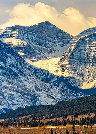
Grinnell Point is located in the Lewis Range, Glacier National Park in the U.S. state of Montana. Grinnell Point is an oft-photographed mountain, situated conspicuously just west of Swiftcurrent Lake across from the Many Glacier Hotel. Grinnell Point is a subpeak of Mount Grinnell, which lies .21 mi (0.34 km) to the west-southwest and is oftentimes misidentified as Mount Grinnell since that summit cannot be seen from the roads in the Many Glacier region. Grinnell Point is named for George Bird Grinnell.
Angel Wing is a 7,430-foot (2,260-meter) elevation mountain summit located in the Lewis Range, of Glacier National Park in the U.S. state of Montana. It is situated one mile east of the Continental Divide, in Glacier County. It can be seen from the Many Glacier area, and up close from the Grinnell Glacier Trail. Topographic relief is significant as the north aspect rises nearly 2,500 feet above Grinnell Lake in one-half mile.
