
The white-crowned sparrow is a species of passerine bird native to North America. A medium-sized member of the New World sparrow family, this species is marked by a grey face and black and white streaking on the upper head. It breeds in brushy areas in the taiga and tundra of the northernmost parts of the continent and in the Rocky Mountains and Pacific coast. While southerly populations in the Rocky Mountains and coast are largely resident, the breeding populations of the northerly part of its range are migratory and can be found as wintering or passage visitors through most of North America south to central Mexico.

The gray-crowned rosy finch or gray-crowned rosy-finch is a species of passerine bird in the family Fringillidae native to Alaska, western Canada, and the north-western United States. Due to its remote and rocky alpine habitat it is rarely seen. There are currently six recognized subspecies. It is one of four species of rosy finches.
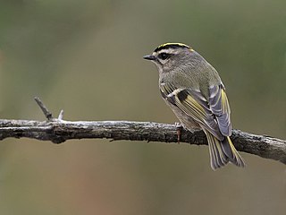
The golden-crowned kinglet is a very small songbird in the family Regulidae that lives throughout much of North America.
Mount Queen Bess is one of the principal summits of the Pacific Ranges of the Coast Mountains of southern British Columbia. It stands west of Chilko Lake and to the south of Tatlayoko Lake, and crowns a peak-studded ridge to the north of the Homathko Icefield.

Officially Good Hope Mountain but commonly known as Mount Good Hope is one of the principal summits of the Pacific Ranges of the southern Coast Mountains in British Columbia, Canada. It stands immediately west of Chilko Lake, with the highest peak on the massif rising between the lake's southern arms.

The Cantilever Range is a mountain range in southwestern British Columbia, Canada, a subrange of the Lillooet Ranges, which is itself a subgrouping of the Pacific Ranges of the Coast Mountains. About 1100 km2 in area and about 50 km east to west and 35 km north to south, the Cantilever Range is located southwest of Lytton between the valleys of the Stein River (N) and Kwoiek Creek (S).
Treaty 2 was entered in to on 21 August 1872 at Manitoba House, Rupertsland, with representatives of the Queen of Great Britain and Ireland. The original Anishinaabe, who were present, constitute Treaty 2 today. It is known that many of the chiefs and leaders within the territory were at the early gathering and after the treaty was agreed to. Those who were not present were represented through Metis until they indicated where they wished their farming reserves to be established. The treaty reaffirmed the inherent rights that the Anishinaabe had prior to European contact, located where southwestern Manitoba is today and a small part of southeastern Saskatchewan.

The coat of arms of Calgary was adopted in 1902. The arms existed only in black and white until 1984, when an alderman asked the city to develop it in full colour.

Crown Mountain is a mountain located north of North Vancouver, British Columbia, in the North Shore Mountains and is visible from most of Vancouver and the vicinity. A rock formation known as The Camel sits just east of the main summit, and the mountain has west and north peaks. The mountain lies on the fringes of Lynn Headwaters Regional Park.
The O'Chiese First Nation is a Saulteaux First Nation in Alberta, Canada. The First Nation's homeland is the 14,131.9 ha O'Chiese 203 Indian reserve, located approximately 52 km northwest of Rocky Mountain House. Also reserved is the O'Chiese Cemetery 203A. As of November 2013, the First Nation had the population of 1,250 registered people, of which the on-reserve population was 831 people. The primary language spoken on the reserve is Western Ojibwa. Though the ancestors of O'Chiese First Nation made the area about the Baptiste River their winter camp site where they hunted moose and deer, and trapped small game for the fur trade, they also migrated in the summer as far south as the Milk River in what is now Montana.

Mount Frederick William is a mountain located at the Queen Reach arm of the Jervis Inlet within the Pacific Ranges of the Coast Mountains in British Columbia Canada. The mountain was named during the 1860 survey by HMS Plumper which charted all of the area and named the mountain after then-Prussian Crown Prince Frederick William, who had married Princess Victoria, the eldest child of Queen Victoria and Prince Albert.

Sunchild 202 is an Indian reserve in Alberta. It is located 44 kilometres (27 mi) northwest of Rocky Mountain House. It is at an elevation of 974 metres (3,196 ft). The population in 2006 was 482. The median age of the population 19.6.

The White Goat Wilderness Area is a provincially designated wilderness area in the Canadian Rockies of Alberta. It was established in 1961 and it, as one of the three wilderness areas of Alberta, has the strictest form of government protection available in Canada. All development is forbidden and only travel by foot is permitted. Hunting and fishing are not allowed. The other two wilderness areas are Ghost River Wilderness Area and Siffleur Wilderness Area and together the three areas total 249,548.80 acres (100,988.82 ha).

The Siffleur Wilderness Area is a provincially designated wilderness area in the Canadian Rockies of Alberta. It was established in 1961 and it, as one of the three wilderness areas of Alberta, has the strictest form of government protection available in Canada. All development is forbidden and only travel by foot is permitted. Hunting and fishing are not allowed. The other two wilderness areas are White Goat Wilderness Area and Ghost River Wilderness Area and together the three areas total 249,548.80 acres (100,988.82 ha).
The White Bear First Nations are a First Nation band government in southeastern Saskatchewan, Canada.

Piapot First Nation is a Cree First Nation in southern Saskatchewan, Canada.
The Wood Mountain First Nation is a Lakota First Nations band government in southern Saskatchewan, Canada. Led across the border by Sitting Bull, they are the only organized Lakota nation in Canada. Their reserve is located at Wood Mountain 160, near Grasslands National Park, although most members reside elsewhere.

The Muscowpetung Saulteaux Nation is a Saulteaux band government in southern Saskatchewan, Canada. Their reserves include:

Day Star First Nation is a First Nations band government in Saskatchewan, Canada. Their reserves include:
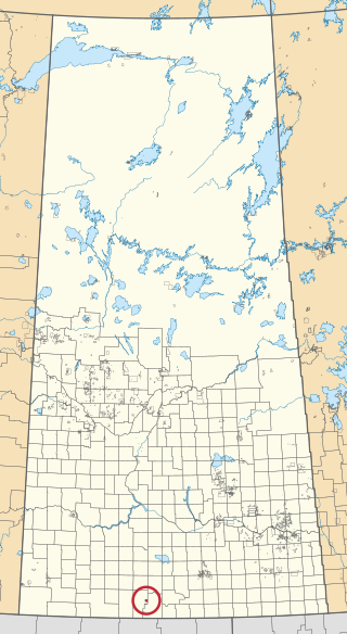
Wood Mountain 160 is an Indian reserve of the Wood Mountain Lakota First Nation in the Wood Mountain Hills of Saskatchewan. It is about 135 kilometres (84 mi) south-west of Moose Jaw. In the 2016 Canadian Census, it recorded a population of 20 living in 11 of its 14 total private dwellings.
