
Ellesmere Island is Canada's northernmost and third largest island, and the tenth largest in the world. It comprises an area of 196,236 km2 (75,767 sq mi), slightly smaller than Great Britain, and the total length of the island is 830 km (520 mi).

Grise Fiord is an Inuit hamlet on the southern tip of Ellesmere Island, in the Qikiqtaaluk Region, Nunavut, Canada. It is one of three populated places on the island; despite its low population, it is the largest community on Ellesmere Island. Created by the Canadian Government in 1953 through a relocation of Inuit families from Inukjuak, Quebec, it is Canada's northernmost public community. It is also one of the coldest inhabited places in the world, with an average yearly temperature of −16.5 °C (2.3 °F).
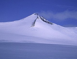
Barbeau Peak is a mountain in Qikiqtaaluk, Nunavut, Canada. Located on Ellesmere Island within Quttinirpaaq National Park, it is the highest mountain in Nunavut and the Canadian Arctic. The mountain was named in 1969 after Marius Barbeau, a Canadian anthropologist whose research into First Nations and Inuit cultures gained him international acclaim.

The United States Range is one of the northernmost mountain ranges of the Arctic Cordillera and in the world, surpassed only by the Challenger Mountains to the northwest. The range is located in the northeastern region of Ellesmere Island in Nunavut, Canada, and is part of the Innuitian Mountains. The highest mountain in the range is Mount Eugene with an elevation of 1,860 metres (6,100 ft). The British Empire Range is immediately to the west of the United States Range.

Eureka is a small research base on Fosheim Peninsula, Ellesmere Island, Qikiqtaaluk Region, in the Canadian territory of Nunavut. It is located on the north side of Slidre Fiord, which enters Eureka Sound farther west. It is the third-northernmost permanent research community in the world. The only two farther north are Alert, which is also on Ellesmere Island, and Nord, in Greenland. Eureka has the lowest average annual temperature and the lowest amount of precipitation of any weather station in Canada.
The Canadian territory of Nunavut covers about 1.9 million square kilometres of land and water including part of the mainland, most of the Arctic islands, and all of the islands in Hudson Bay, James Bay, and Ungava Bay which belonged to the Northwest Territories. This makes it the fifth largest country subdivision in the world. If Nunavut were a country, it would rank 13th in area, after the Democratic Republic of the Congo. Nunavut has land borders with Manitoba, the Northwest Territories on several islands as well as the mainland, and a tiny land border with Newfoundland and Labrador on Killiniq Island. Additionally, Nunavut has a land border with Greenland on Hans Island.

The Arctic Cordillera is a terrestrial ecozone in northern Canada characterized by a vast, deeply dissected chain of mountain ranges extending along the northeastern flank of the Canadian Arctic Archipelago from Ellesmere Island to the northeasternmost part of the Labrador Peninsula in northern Labrador and northern Quebec, Canada. It spans most of the eastern coast of Nunavut with high glaciated peaks rising through ice fields and some of Canada's largest ice caps, including the Penny Ice Cap on Baffin Island. It is bounded to the east by Baffin Bay, Davis Strait and the Labrador Sea while its northern portion is bounded by the Arctic Ocean.
The Prince of Wales Mountains are a mountain range running along the central-east coast of Ellesmere Island, Nunavut, Canada. The range is one of the most northern ranges in the world and of the Arctic Cordillera, which is a vast deeply dissected mountain range from Ellesmere Island to the northernmost tip of Labrador. The Prince of Wales Icefield lies mostly in the range.
Commonwealth Mountain is a mountain on Ellesmere Island, Nunavut, Canada. It lies in western Quttinirpaaq National Park, which is the most northerly extent of Canada, and is the second most northerly park on Earth after Northeast Greenland National Park.

The Conger Range, also called the Conger Mountains, is a mountain range in Quttinirpaaq National Park on Ellesmere Island, Nunavut, Canada, beginning about 16 km (10 mi) west of Mount Osborne. It is part of the Arctic Cordillera which is a vast dissected mountain system extending from Ellesmere Island to the northernmost tip of Labrador and northeastern Quebec. The Conger Range is a structural extension of the Garfield Range and continues into the highlands north of the head of Hare Fiord. The overall extent of the range is about 180 km (112 mi). Most of its peaks are ice-covered, although nearly all of the southern slopes are ice-free. Many of the valleys between the peaks are filled with glacial tongues spilling out to the south from the Grand Land Ice Cap. Its highest point is Mount Biederbick at 1,542 m (5,059 ft).
Norman Lockyer Island is located off the eastern coast of Ellesmere Island, and a part of the Qikiqtaaluk Region of the Canadian territory of Nunavut. Situated in Princess Marie Bay just in front of Franklin Pierce Bay, 9 km (5.6 mi) WSW of Cape Prescott, north of Bache Peninsula, Norman Lockyer Island is within the Arctic Archipelago, a member of the Queen Elizabeth Islands.
The Fosheim Peninsula is located in western Ellesmere Island, a part of the Qikiqtaaluk Region of the Canadian territory of Nunavut. Eureka, a permanent research community, is located on the north side of Slidre Fiord, a few kilometers east of Eureka Sound. While the peninsula was first sighted by the Arctic explorer Adolphus Greely in 1881, it was not explored until 1899 by Otto Sverdrup, who named it after Ivar Fosheim, a member of his expedition.
The Cook Peninsula is located on the eastern coast of Ellesmere Island, a part of the Qikiqtaaluk Region of the Canadian territory of Nunavut. North of Princess Marie Bay, it stretches eastward into Nares Strait. The peninsula is approximately 64 square kilometres (25 sq mi) in size, and has two lowland areas frequented by muskox.
Irene Bay is an Arctic waterway in the Qikiqtaaluk Region. Nunavut, Canada. It is located in Eureka Sound by western Ellesmere Island.
Peary Bay is an Arctic waterway in the Qikiqtaaluk Region, Nunavut, Canada. It is located in Nares Strait by eastern Ellesmere Island between the Cook Peninsula and the Bache Peninsula.
The Gretha Islands are an uninhabited island group located in the Qikiqtaaluk Region of Nunavut, Canada. They are situated in Eureka Sound at the confluence of Bay Fjord, north of Ellesmere Island's Raanes Peninsula, and east of Stor Island. They are members of the Sverdrup Islands group, Queen Elizabeth Islands, and the Arctic Archipelago.
Hat Island is an uninhabited island located in the Qikiqtaaluk Region of Nunavut, Canada. It is situated in Eureka Sound, at the confluence of Bay Fjord, east of Ellesmere Island's Raanes Peninsula and 19.6 km (12.2 mi) west of Stor Island. It is a member of the Sverdrup Islands group and the Arctic Archipelago. It is also a member of the Queen Elizabeth Islands and the Arctic Archipelago.
Strathcona Fiord is a fiord on the west central coast of Ellesmere Island, the most northern island within the Arctic Archipelago, Nunavut, Canada.
The Eurekan orogeny was a Phanerozoic mountain building event that affected the eastern portion of the Arctic Archipelago and, to a lesser extent, northern Greenland. Deformation initiated in the Late Cretaceous, during which time the Sverdrup Basin began to fragment and fold in response to the counterclockwise rotation of Greenland, caused by seafloor spreading in the Canadian Arctic Rift System. Isostatic uplift was most pronounced in the Grantland Mountains and Victoria and Albert Mountains on Ellesmere Island and in the Princess Margaret Range on Axel Heiberg Island, as evidenced by the current physiography. Compression in a broad zone on Ellesmere Island resulted in the formation of the Eurekan Fold Belt.


