The Arctic Archipelago, also known as the Canadian Arctic Archipelago, is an archipelago lying to the north of the Canadian continental mainland, excluding Greenland and Iceland.

Baffin Bay, located between Baffin Island and the west coast of Greenland, is defined by the International Hydrographic Organization as a marginal sea of the Arctic Ocean. It is sometimes considered a sea of the North Atlantic Ocean. It is connected to the Atlantic via Davis Strait and the Labrador Sea. The narrower Nares Strait connects Baffin Bay with the Arctic Ocean. The bay is not navigable most of the year because of the ice cover and high density of floating ice and icebergs in the open areas. However, a polynya of about 80,000 km2 (31,000 sq mi), known as the North Water, opens in summer on the north near Smith Sound. Most of the aquatic life of the bay is concentrated near that region.

Devon Island is an island in Canada and the largest uninhabited island in the world. It is located in Baffin Bay, Qikiqtaaluk Region, Nunavut, Canada. It is one of the largest members of the Arctic Archipelago, the second-largest of the Queen Elizabeth Islands, Canada's sixth-largest island, and the 27th-largest island in the world. It has an area of 55,247 km2 (21,331 sq mi). The bedrock is Precambrian gneiss and Paleozoic siltstones and shales. The highest point is the Devon Ice Cap at 1,920 m (6,300 ft) which is part of the Arctic Cordillera. Devon Island contains several small mountain ranges, such as the Treuter Mountains, Haddington Range and the Cunningham Mountains. The notable similarity of its surface to that of Mars has attracted interest from scientists.

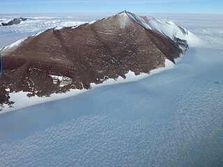
The Pensacola Mountains are a large group of mountain ranges and peaks that extend 280 nautical miles in a northeast–southwest direction in the Transantarctic Mountains System, Queen Elizabeth Land region of Antarctica. They comprise the Argentina Range, Forrestal Range, Dufek Massif, Cordiner Peaks, Neptune Range, Patuxent Range, Rambo Nunataks and Pecora Escarpment. These mountain units lie astride the extensive Foundation Ice Stream and Support Force Glacier which drain northward to the Ronne Ice Shelf.
The Forrestal Range is a largely snow-covered mountain range, about 65 nautical miles long, standing east of Dufek Massif and the Neptune Range in the Pensacola Mountains, Antarctica.

The Annapolis Basin is a sub-basin of the Bay of Fundy, located on the bay's southeastern shores, along the northwestern shore of Nova Scotia and at the western end of the Annapolis Valley.
The Stikine Ranges are a group of mountain ranges and mountainous plateaus in northwestern British Columbia, Canada. They are the northernmost subdivision of the Cassiar Mountains and among the least explored and most undeveloped parts of the province.
The Victoria and Albert Mountains are a mountain range running on the east coast of Ellesmere Island, Nunavut, Canada. The range is one of the most northern ranges in the world and of the Arctic Cordillera. The highest mountain in the range is Agassiz Ice Cap Summit at 2,201 m (7,221 ft). The range has an area of 37,650 km2 (14,540 sq mi).

The Dufek Massif is a rugged, largely snow-covered massif 27 nautical miles long, standing west of the Forrestal Range in the northern part of the Pensacola Mountains, Antarctica.
The Cunningham Mountains are a small mountain range on the southeastern coast of Devon Island, Nunavut, Canada. The Cunningham Mountains are part of the Devon Ice Cap which forms part of the Arctic Cordillera mountain range.
The Scoresby Hills, also called the Scoresby Mountains, are a mountain range on the east coast of Bathurst Island, Nunavut, Canada. It consists of low hills which in turn form part of the Arctic Cordillera mountain system.
The Haddington Range is a mountain range on northeastern Devon Island, Nunavut, Canada. It is one of the northernmost mountain ranges in the world forming part of the Arctic Cordillera mountain system.
The Grinnell Range is a mountain range on northwestern Devon Island, Nunavut, Canada. It is one of the northernmost mountain ranges in the world forming part of the Arctic Cordillera mountain system.
Piper Pass is a mountain pass in the United States Range, Nunavut, Canada.
The Boulder Hills are a mountain range in northeastern Quttinirpaaq National Park, Ellesmere Island, Nunavut, Canada. It is associated with the Arctic Cordillera mountain system.
The Nass Ranges are a mountain range north of the Skeena River, west of Hazelton, and northeast of Terrace, British Columbia, Canada. It is a subrange of the Hazelton Mountains, which in turn form part of the Interior Mountains.
The Oweegee Range is a small subrange of the Skeena Mountains of the Interior Mountains, located on the east side of Bell-Irving River in northern British Columbia, Canada.
The Ratchford Range is a subrange of the Monashee Mountains of the Columbia Mountains, located east of the Seymour River in British Columbia, Canada.
The Pembroke Range is a small mountain range in southwestern British Columbia, Canada, between Loughborough Inlet and Phillips Arm. It has an area of 75 km2 and is a subrange of the Pacific Ranges which in turn form part of the Coast Mountains.

Dundas Harbour is an abandoned settlement in the Qikiqtaaluk Region, Nunavut, Canada. It is located on Devon Island at the eastern shore of the waterway also named Dundas Harbour. Baffin Bay's Croker Bay is immediately to the west.


