Related Research Articles
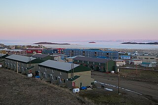
Frobisher Bay is an inlet of the Davis Strait in the Qikiqtaaluk Region of Nunavut, Canada. It is located in the southeastern corner of Baffin Island. Its length is about 230 km (140 mi) and its width varies from about 40 km (25 mi) at its outlet into the Labrador Sea to roughly 20 km (12 mi) towards its inner end.

Baffin Bay, located between Baffin Island and the west coast of Greenland, is defined by the International Hydrographic Organization as a marginal sea of the Arctic Ocean. It is sometimes considered a sea of the North Atlantic Ocean. It is connected to the Atlantic via Davis Strait and the Labrador Sea. The narrower Nares Strait connects Baffin Bay with the Arctic Ocean. The bay is not navigable most of the year because of the ice cover and high density of floating ice and icebergs in the open areas. However, a polynya of about 80,000 km2 (31,000 sq mi), known as the North Water, opens in summer on the north near Smith Sound. Most of the aquatic life of the bay is concentrated near that region.

Boyana Glacier in Levski Ridge, Tangra Mountains on Livingston Island, South Shetland Islands in Antarctica is situated southeast of Macy Glacier and west-southwest of Srebarna Glacier. It is bounded by Vazov Rock on the west, St. Naum Peak, Starosel Gate, Silistra Knoll and Kotel Gap on the north, and Christoff Cliff on the east. The glacier extends 3 km in east-west direction and 1.6 km in north-south direction, and flows southeastward into the Bransfield Strait between Vazov Point and Aytos Point.

Shawmut Peninsula is the promontory of land on which Boston, Massachusetts was built. The peninsula, originally a mere 789 acres (3.19 km2) in area, more than doubled in size due to land reclamation efforts that were a feature of the history of Boston throughout the 19th century.
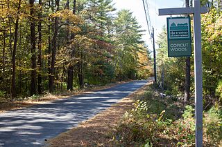
Copicut Woods is a nature reserve and forest located in Fall River, Massachusetts. The property was acquired by The Trustees of Reservations in 2002. It is a component of the 13,600 acre Southeastern Massachusetts Bioreserve.

Coronation Glacier is a glacier on southeastern Baffin Island, Nunavut, Canada. The glacier is on the northeast coast of Cumberland Peninsula and is an outlet glacier of the Penny Ice Cap. The Coronation Glacier lost its connection to the Elena Glacier between 1943 and 1949.
West Pioneer Glacier is a glacier located on the central coast of Baffin Island, Nunavut, Canada.
Jimi Maasi Glacier is a glacier in northeastern Baffin Island, Nunavut, Canada.
Utinatuk Glacier is a glacier located on the central coast of Baffin Island, Nunavut, Canada.
Nuuksuq Glacier is a glacier located on the central coast of Baffin Island, Nunavut, Canada.
Keyhole Glacier is a glacier located in the central Baffin Mountains of northeastern Baffin Island, Nunavut, Canada.
Kiitarayuk Glacier is a glacier located on the central coast of the Baffin Mountains on northeastern Baffin Island, Nunavut, Canada.
Oliver Glacier is a glacier located on the northeast coast of the Baffin Mountains on Baffin Island, Nunavut, Canada. It is just outside Sirmilik National Park.
Coutts Inlet is a body of water in Nunavut's Qikiqtaaluk Region. It is an arm of Baffin Bay in northeastern Baffin Island. The inlet flows in a southwestern direction and includes a northern arm that juts off the main inlet close to the mouth. Nova Zembla Island and Round Island are located near the mouth of Coutts Inlet.
The Glacier Strait is a natural waterway through the Canadian Arctic Archipelago within Qikiqtaaluk Region, Nunavut, Canada. It separates Ellesmere Island from Coburg Island. To the north-east it opens into Baffin Bay, and to the south-west into the Jones Sound.

Illullip Sermia is a tidewater glacier in Avannaata municipality on the northwestern shore of Greenland. It drains the Greenland ice sheet southwestwards into Inussulik Bay, an inlet of Baffin Bay. The glacier front is located between the Sanningassorsuaq Peninsula in the north, and the base of Illulissuaq Peninsula in the south. The glacier front is located at 74°22′40″N56°04′50″W.
Upernavik Icefjord is a fjord in Avannaata municipality in northwestern Greenland.
Sanningassoq Island is an island of Greenland. It is located in Baffin Bay in the Upernavik Archipelago.

Turner Glacier is a glacier on the east side of Mount Liotard flowing northeast into Ryder Bay, Adelaide Island. The glacier was surveyed by Falkland Islands Dependencies Survey (FIDS), 1948, and photographed from the air by Falkland Islands and Dependencies Aerial Survey Expedition (FIDASE), 1956–57. Named by the United Kingdom Antarctic Place-Names Committee (UK-APC) in 1977 after Andrew John Turner, British Antarctic Survey (BAS) builder, Halley Station, 1973–74; Signy Island, 1974–75; Rothera Station, 1976–77, 1978–80; and Faraday Station, 1982–83.
Esmarkbreen is a glacier in Oscar II Land at Spitsbergen, Svalbard. It is named after geologist Jens Esmark. The glacier has a length of 15 kilometers, and debouches into the bay Ymerbukta at the northern side of Isfjorden.
References
Coordinates: 72°21′28″N075°42′18″W / 72.35778°N 75.70500°W
| | This Qikiqtaaluk Region, Nunavut location article is a stub. You can help Wikipedia by expanding it. |
| | This article about a glacier in Canada is a stub. You can help Wikipedia by expanding it. |