
Ellesmere Island is Canada's northernmost and third largest island, and the tenth largest in the world. It comprises an area of 196,236 km2 (75,767 sq mi), slightly smaller than Great Britain, and the total length of the island is 830 km (520 mi).

Baffin Island, in the Canadian territory of Nunavut, is the largest island in Canada, the second-largest island in the Americas, and the fifth-largest island in the world. Its area is 507,451 km2 (195,928 sq mi) with a population density of 0.03/km2; the population was 13,039 according to the 2021 Canadian census; and it is located at 68°N70°W. It also contains the city of Iqaluit, which is the capital of Nunavut.

Baffin Bay, located between Baffin Island and the west coast of Greenland, is defined by the International Hydrographic Organization as a marginal sea of the Arctic Ocean. It is sometimes considered a sea of the North Atlantic Ocean. It is connected to the Atlantic via Davis Strait and the Labrador Sea. The narrower Nares Strait connects Baffin Bay with the Arctic Ocean. The bay is not navigable most of the year because of the ice cover and high density of floating ice and icebergs in the open areas. However, a polynya of about 80,000 km2 (31,000 sq mi), known as the North Water, opens in summer on the north near Smith Sound. Most of the aquatic life of the bay is concentrated near that region.

Bylot Island lies off the northern end of Baffin Island in Nunavut Territory, Canada. Eclipse Sound to the southeast and Navy Board Inlet to the southwest separate it from Baffin Island. Parry Channel lies to its northwest. At 11,067 km2 (4,273 sq mi) it is ranked 71st largest island in the world and Canada's 17th largest island. The island measures 180 km (110 mi) east to west and 110 km (68 mi) north to south and is one of the largest uninhabited islands in the world. While there are no permanent settlements on this Canadian Arctic island, Inuit from Pond Inlet and elsewhere regularly travel to Bylot Island. An Inuit seasonal hunting camp is located southwest of Cape Graham Moore.

Auyuittuq National Park is a national park located on Baffin Island's Cumberland Peninsula, in the Qikiqtaaluk Region of Nunavut, the largest political subdivision of Canada. The park was initially known as Baffin Island National Park when it was established in 1972, but the name was changed in 1976 to its current name to better reflect the region and its history. It features many terrains of Arctic wilderness, such as fjords, glaciers, and ice fields. Although Auyuittuq was established in 1972 as a national park reserve, it was upgraded to a full national park in 2000.

Sirmilik National Park is a national park located in Qikiqtaaluk, Nunavut, Canada, established in 1999. Situated within the Arctic Cordillera, the park is composed of three areas: most of Bylot Island with the exception for a few areas that are Inuit-owned lands, Kangiqłuruluk, and Baffin Island's Borden Peninsula. Much of the park is bordered by water.

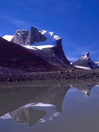
Mount Asgard is a twin peaked mountain with two flat-topped, cylindrical, rock towers, separated by a saddle. It is located in Auyuittuq National Park, on the Cumberland Peninsula of Baffin Island, Nunavut, Canada. The peak is named after Asgard, the realm of the Æsir (gods) in Norse mythology. Mount Asgard is perhaps the most famous of the Baffin Mountains.

Mount Thor, officially gazetted as Thor Peak, is a mountain with an elevation of 1,675 m (5,495 ft) located in Auyuittuq National Park, on Baffin Island, Nunavut, Canada. The mountain is located 46 km (29 mi) northeast of Pangnirtung and features Earth's greatest vertical drop of 1,200 m (4,100 ft), with the cliff overhanging at an average angle of 105 degrees. Despite its remoteness, this feature makes the mountain a popular rock climbing site. Camping is allowed, with several designated campsites located throughout the length of Akshayuk Pass. For climbers looking to scale Mount Thor, there is an established campsite a few kilometres north of its base, complete with windbreaks and emergency shelters.
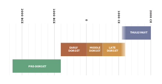
The history of Nunavut covers the period from the arrival of the Paleo-Eskimo thousands of years ago to present day. Prior to the colonization of the continent by Europeans, the lands encompassing present-day Nunavut were inhabited by several historical cultural groups, including the Pre-Dorset, the Dorsets, the Thule and their descendants, the Inuit.

The Baffin Mountains are a mountain range running along the northeastern coast of Baffin Island and Bylot Island, Nunavut, Canada. The ice-capped mountains are part of the Arctic Cordillera and have some of the highest peaks of eastern North America, reaching a height of 1,525–2,146 metres (5,003–7,041 ft) above sea level. While they are separated by bodies of water to make Baffin Island, they are closely related to the other mountain ranges that make the much larger Arctic Cordillera mountain range.

Mount Odin is a mountain in Qikiqtaaluk, Nunavut, Canada. It is located in Auyuittuq National Park along the Akshayuk Pass, 46 km (29 mi) north of Pangnirtung and south of Mount Asgard. Mount Odin is the highest mountain on Baffin Island.

The Byam Martin Mountains are a rugged mountain range extending the length of Bylot Island, Nunavut, Canada. It is one of the most northern ranges in the world and is an extension of the Baffin Mountains, which in turn form part of the Arctic Cordillera mountain system. The highest mountain in the range is Angilaaq Mountain at 1,951 m (6,401 ft), located near the island's center. Sharp peaks and ridges, divided by deep glacier-filled valleys, are typical features in the range and has been extensively modified by glacial erosion. The Byam Martin Mountains have not been conducive to habitation. While there are no permanent settlements in the Byam Martin Mountains, Inuit from Pond Inlet and elsewhere regularly travel to the range.
Breidablik Peak is a mountain on Baffin Island, located 51 km (32 mi) northeast of Pangnirtung, Nunavut, Canada. It lies in the southern Baffin Mountains which in turn form part of the Arctic Cordillera mountain system. Like Mounts Odin and Asgard and other peaks in the Arctic Cordillera, its name comes from Norse mythology. It is named after Breidablik, the home of Baldr.
Mount Baldr is a mountain on Baffin Island, located 49 km (30 mi) northeast of Pangnirtung, Nunavut, Canada. It lies in the southern Baffin Mountains, which in turn form part of the Arctic Cordillera mountain system. Like nearby Breidablik Peak and Mount Odin and other peaks in the Arctic Cordillera, its name comes from Norse mythology. It is named after Baldr, a god in Germanic paganism and is Odin's second son.
Akshayuk Pass formerly Pangnirtung Pass is a mountain pass in the Baffin Mountains of Nunavut, Canada. It is found within Auyuittuq National Park. To the southwest is Mount Thor, about 17 km (11 mi), and Pangnirtung, about 64 km (40 mi) and to the northeast is Qikiqtarjuaq, about 109 km (68 mi).
Mount Battle is a mountain located 65 km (40 mi) northeast of Pangnirtung on Baffin Island, Nunavut, Canada. It is part of the Baffin Mountains which in turn form part of the Arctic Cordillera mountain system.
Mount Nukap is a mountain associated with the Baffin Mountains on Baffin Island, Nunavut, Canada.

Mallik Island is one of the uninhabited Canadian arctic islands of Qikiqtaaluk Region, Nunavut, Canada. It is located in Hudson Strait between Baffin Island's Foxe Peninsula and Dorset Island. Mallik Island and Dorset Island are joined by sand and boulders. Cape Dorset, an Inuit hamlet, is approximately 4.5 km (2.8 mi) away.

Dorset Island, or Cape Dorset Island, is one of the Canadian Arctic islands located in Hudson Strait, Nunavut, Canada. It lies off the Foxe Peninsula area of southwestern Baffin Island in the Qikiqtaaluk Region. It is serviced by an airport and a harbour.

Sylvia Grinnell Territorial Park is a Canadian territorial park on Baffin Island in the territory of Nunavut.
