| Singeyer Pass | |
|---|---|
 Location in Nunavut | |
| Location | Nunavut, Canada |
| Coordinates | 62°55′01″N064°49′50″W / 62.91694°N 64.83056°W |
| Topo map | NTS 25I15 Williams Peninsula |
Singeyer Pass is a mountain pass on southern Baffin Island, Nunavut, Canada. [1]
| Singeyer Pass | |
|---|---|
| Location in Nunavut | |
| Location | Nunavut, Canada |
| Coordinates | 62°55′01″N064°49′50″W / 62.91694°N 64.83056°W |
| Topo map | NTS 25I15 Williams Peninsula |
Singeyer Pass is a mountain pass on southern Baffin Island, Nunavut, Canada. [1]
Wapiti Pass is a mountain pass in the Northern Rocky Mountains of British Columbia, Canada. It lies immediately east of Wapiti Lake Provincial Park, at the headwaters of the Wapiti River, northeast of Prince George and west of Monkman Provincial Park.

Abbot Pass lies between Mount Lefroy and Mount Victoria, in the divide between the valleys of Lake O'Hara and Lake Louise. It was named for Philip Stanley Abbot who died in 1896 in an attempt to climb Mount Lefroy with Charles Fay, Charles Thompson, and George T. Little.

Elbow Pass is the mountain pass between the Highwood and Elbow areas in Kananaskis Country, Alberta, Canada. It contains Elbow Lake which is the headwaters of the Elbow River.

Sinclair Pass is a high mountain pass in Kootenay National Park between the Columbia and Kootenay Rivers to the northeast of present-day Radium Hot Springs in the province of British Columbia, Canada.
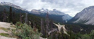
Sunwapta Pass is a mountain pass in the Canadian Rockies in the province of Alberta. Sunwapta Pass is the low point of the saddle created between Mount Athabasca and Nigel Peak. The pass marks the boundary between Banff and Jasper national parks. The Icefields Parkway travels through Sunwapta Pass 108 km (67 mi) southeast of the town of Jasper and 122 km (76 mi) northwest of the Parkway's junction with the Trans-Canada Highway near Lake Louise. The pass is the second highest point on the Icefields Parkway. Bow Summit in Banff National Park is the highest point on the parkway.
Piper Pass is a mountain pass in the United States Range, Nunavut, Canada.
Railroad Pass, 1,385 m (4,544 ft), usually known locally as Railway Pass, is a mountain pass in the Pacific Ranges of the Coast Mountains in southwestern British Columbia, Canada. Traversed by a seasonal dirt road known as the Hurley Main and sometimes also referred to therefore as Hurley Pass, the pass connects the Pemberton Meadows area of the upper valley of the Lillooet River, via Railroad Creek, to the uppermost reaches of the Hurley River, the main south fork of the Bridge River which the Hurley joins at the settlement of Gold Bridge.
Bush Pass is a mountain pass in the Canadian Rockies, on the border between the Canadian provinces of Alberta and British Columbia. It is located at the headwaters of the Valenciennes River, formerly known as the South Fork Bush River; the North Fork Bush River is now known as the Bush River.
Simpson Pass, el. 2,107 m (6,913 ft), is a mountain pass on the border between the Canadian provinces of Alberta and British Columbia, in the area of the Ball Range. It is the prominence col for Mount Ball on the Continental Divide in the vicinity of Sunshine Village ski resort. Simpson River and Simpson Pass are named after Sir George Simpson who first explored the area in 1841.

Vermilion Pass, elevation 1,680 m or 5,510 ft, is a high mountain pass in the Canadian Rockies, traversing the continental divide. It connects Kootenay National Park in the province of British Columbia with Banff National Park in Alberta.

The Fraser Pass is a mountain pass in the British Columbian Rockies of Western Canada. Its summit is 2,015 m (6,611 ft) above sea level. Although immediately adjacent to the Continental Divide, the pass does not cross it; rather, it bridges the drainage basins of the Fraser River and Columbia River, both Pacific-draining rivers.
Wedge Pass, also known as Billygoat Pass, 1,430 m (4,690 ft), is a mountain pass in the northern Garibaldi Ranges, the southwesternmost subdivisions of the Pacific Ranges of the Coast Mountains in British Columbia, Canada. Located immediately on the southern flank of Wedge Mountain and to the immediate north of the Spearhead Range, site of the Blackcomb half of the Whistler Blackcomb Ski Area, it connects the head of Wedge Creek (W), a tributary of the Green River with those of Billgoat Creek (E), a tributary of the Lillooet River. The pass is within Garibaldi Provincial Park and has no road access.

Highwood Pass is a mountain pass in Kananaskis Country, Alberta, Canada. It lies west of Mount Rae and Mount Arethusa of the Misty Range, south of Elbow Pass. It lies within the Peter Lougheed Provincial Park on Alberta Highway 40. The Highwood River originates in the pass.
Jarvis Pass is a mountain pass in Kakwa Provincial Park in the Northern Rockies of British Columbia, Canada, located to the north of Kakwa Lake, on the British Columbia-Alberta boundary, and therefore is on the Continental Divide. It was one of the many passes surveyed as a route for the Canadian Pacific Railway in the 1870s.
Carcajou Pass is a mountain pass on the Continental Divide and British Columbia–Alberta boundary at the north end of Mount Robson Provincial Park. On the Alberta side lies the northwestern part of Jasper National Park. Carcajou is the French word for "wolverine".
Summit Pass is a high mountain pass in the Northern Canadian Rockies in the province of British Columbia. It is one of two passes the Alaska Highway utilizes to cut westwards across ranges of the Rocky Mountain System; further north is the lower Muncho Pass.
Muncho Pass, also known as Muncho Lake Pass, Drogheda Lake Pass, or Muncho-Toad Pass, is the northernmost mountain pass in the Rocky Mountains to be traversed by a public highway. Located in Muncho Lake Provincial Park, British Columbia, Canada, the pass links the Toad River and Trout River drainages. The Alaska Highway travels across the pass.
Fortress Pass is a mountain pass that crosses the continental divide in the Canadian Rockies, south of Jasper, Alberta. At 1,335 metres (4,380 ft), Fortress Pass is one of the lowest passes to cross the Canadian Rockies that is not traversed by a road. In addition to being at a low elevation, Fortress Pass is also relatively gentle, with almost no elevation difference between water bodies on either side.
Palliser Pass, 2,084 m (6,837 ft), is a mountain pass in the Canadian Rockies, located on the British Columbia / Alberta boundary at the south end of Banff National Park and at the north end of Height of the Rockies Provincial Park in British Columbia. The pass is located north of the headwaters of the Palliser River.
Tonquin Pass, 1948 m (6393 ft), is a mountain pass in the Canadian Rockies, linking Tonquin Valley in Jasper National Park, Alberta, to Mount Robson Provincial Park and adjoining areas of British Columbia. It is at the headwaters of Tonquin Creek, which flows into British Columbia. Located on the interprovincial boundary, it is on the Continental Divide.
| | This article related to a mountain, mountain range, or peak in Canada is a stub. You can help Wikipedia by expanding it. |
| | This Qikiqtaaluk Region, Nunavut location article is a stub. You can help Wikipedia by expanding it. |