
Sir John Ross was a Scottish Royal Navy officer and polar explorer. He was the uncle of Sir James Clark Ross, who explored the Arctic with him, and later led expeditions to Antarctica.
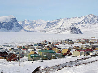
Pangnirtung is an Inuit hamlet, in the Qikiqtaaluk Region of the Canadian territory of Nunavut, located on Baffin Island. The community is located about 45 km (28 mi) south of the Arctic Circle, and about 2,700 km (1,700 mi) from the North Pole. Pangnirtung is situated on a coastal plain at the coast of Pangnirtung Fjord, a fjord which eventually merges with Cumberland Sound. As of January 2022, the mayor is Lynn Mike.

Melville Island is an uninhabited member of the Queen Elizabeth Islands of the Arctic Archipelago. With an area of 42,149 km2 (16,274 sq mi), it is the 33rd largest island in the world and Canada's eighth largest island.

Devon Island is an island in Canada and the largest uninhabited island in the world. It is located in Baffin Bay, Qikiqtaaluk Region, Nunavut, Canada. It is one of the largest members of the Arctic Archipelago, the second-largest of the Queen Elizabeth Islands, Canada's sixth-largest island, and the 27th-largest island in the world. It has an area of 55,247 km2 (21,331 sq mi). The bedrock is Precambrian gneiss and Paleozoic siltstones and shales. The highest point is the Devon Ice Cap at 1,920 m (6,300 ft) which is part of the Arctic Cordillera. Devon Island contains several small mountain ranges, such as the Treuter Mountains, Haddington Range and the Cunningham Mountains. The notable similarity of its surface to that of Mars has attracted interest from scientists.

King William Island is an island in the Kitikmeot Region of Nunavut, which is part of the Arctic Archipelago. In area it is between 12,516 km2 (4,832 sq mi) and 13,111 km2 (5,062 sq mi) making it the 61st-largest island in the world and Canada's 15th-largest island. Its population, as of the 2021 census, was 1,349, all of whom live in the island's only community, Gjoa Haven.

Tuktoyaktuk, or TuktuyaaqtuuqIPA:[təktujaːqtuːq], is an Inuvialuit hamlet located near the Mackenzie River delta in the Inuvik Region of the Northwest Territories, Canada, at the northern terminus of the Inuvik–Tuktoyaktuk Highway. One of six Inuvialuit communities in the Inuvialuit Settlement Region, it is commonly referred to by its first syllable, Tuk. It lies north of the Arctic Circle on the shores of the Arctic Ocean, and is the only place on the Arctic Ocean connected to the rest of Canada by road. Known as Port Brabant after British colonization, in 1950 it became the first Indigenous settlement in Canada to reclaim its traditional name.

The Cobourg Peninsula is located 350 kilometres (217 mi) east of Darwin in the Northern Territory, Australia. It is deeply indented with coves and bays, covers a land area of about 2,100 square kilometres (811 sq mi), and is virtually uninhabited with a population ranging from about 20 to 30 in five family outstations, but without any notable settlement or village. It is separated from Croker Island in the east by Bowen Strait, which is 2.5 kilometres wide in the south and up to 7 kilometres in the north, and 8.5 kilometres long. In the west, it is separated from Melville Island by Dundas Strait. From Cape Don, the western point of the peninsula, to Soldier Point in the east of Melville Island, the distance is 28 kilometres (17 mi). In the north is the Arafura Sea, and in the south the Van Diemen Gulf. The highest elevation is Mount Roe in the south with an altitude of 160 metres (525 ft).

Coral Harbour is a small Inuit community that is located on Southampton Island, Kivalliq Region, in the Canadian territory of Nunavut. Its name is derived from the fossilized coral that can be found around the waters of the community which is situated at the head of South Bay. The name of the settlement in Inuktitut is Salliq, sometimes used to refer to all of Southampton Island. The plural Salliit, means large flat island(s) in front of the mainland.

The locality Port Leopold is an abandoned trading post in the Qikiqtaaluk Region of Nunavut, Canada. It faces Prince Regent Inlet at the northeast tip of Somerset Island.
Dundas Island is a member of the Queen Elizabeth Islands and the Arctic Archipelago in the territory of Nunavut. It is an irregularly shaped island located between Devon Island and Baillie-Hamilton Island. The smaller Margaret Island is 1 km (0.62 mi) to the east of Dundas.
Wellington Bay is an Arctic waterway in Kitikmeot Region, Nunavut, Canada. It is located in Dease Strait, off southern Victoria Island. It is about 65 km (40 mi) northwest of the community of Cambridge Bay.

Dorset Island, or Cape Dorset Island, is one of the Canadian Arctic islands located in Hudson Strait, Nunavut, Canada. It lies off the Foxe Peninsula area of southwestern Baffin Island in the Qikiqtaaluk Region. It is serviced by an airport and a harbour.
The Croker River is a waterway above the Arctic Circle on the mainland of Northern Canada in the western Kitikmeot Region, Nunavut. It is the largest river between Darnley Bay and Coronation Gulf that flows into Amundsen Gulf. The Croker averages 55 m (180 ft) in width.
Native Bay is a waterway in the Kivalliq Region, Nunavut, Canada. It is located in Hudson Bay off western Southampton Island. The Bell Peninsula lies to the southeast. Native Point is located at the bay's southern tip. East Bay is 20 km (12 mi) to the east and Coral Harbour is 36 km (22 mi) to the north northwest.
Brae Bay is an Arctic waterway in the Qikiqtaaluk Region, Nunavut, Canada. It is located in Jones Sound by northern Devon Island, just north of the Devon Ice Cap and 12 km (7.5 mi) north of the Sverdrup Glacier (75°40′40″N83°16′20″W}.
South Bay is a waterway in the Kivalliq Region, Nunavut, Canada. It is located in Hudson Bay, off southwestern Southampton Island. It is west of Native Bay. The Kirchoffer River empties into the bay.
The East Bay (Qaqsauqtuuq) Migratory Bird Sanctuary, Qaqsauqtuuq Migratory Bird Sanctuary, or Refuge d'oiseaux de la baie Est is a migratory bird sanctuary in the Kivalliq Region, Nunavut, Canada. It is located in East Bay, an arm of Hudson Bay, in southeast Southampton Island. The nearest community is Coral Harbour, 35 km (22 mi) to the west.

Dundas Harbour is an abandoned settlement in the Qikiqtaaluk Region, Nunavut, Canada. It is located on Devon Island at the eastern shore of the waterway also named Dundas Harbour. Baffin Bay's Croker Bay is immediately to the west.
Cory Bay is an arm of the Foxe Basin in the Qikiqtaaluk Region of Nunavut, Canada. It is located on northeastern Foxe Peninsula, in western Baffin Island. The closest community is Kinngait, situated 163 km (101 mi) to the south, while Nuwata, a former settlement, is situated about 148 km (92 mi) to the west.

