
Robert Edwin Peary Sr. was an American explorer and officer in the United States Navy who made several expeditions to the Arctic in the late 19th and early 20th centuries. He was long credited as being the discoverer of the geographic North Pole in April 1909, having led the first expedition to have claimed this achievement, although it is now considered unlikely that he actually reached the Pole.

Ellesmere Island is Canada's northernmost and third largest island, and the tenth largest in the world. It comprises an area of 196,236 km2 (75,767 sq mi), slightly smaller than Great Britain, and the total length of the island is 830 km (520 mi).
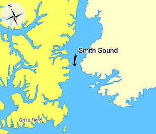
Smith Sound is an Arctic sea passage between Greenland and Nunavut's northernmost island, Ellesmere Island. It links Baffin Bay with Kane Basin and forms part of the Nares Strait. On the Canadian side it extends from Cape Sabine in the north to Cape Isabella in the south.

Effie M. Morrissey is a schooner skippered by Robert Bartlett that made many scientific expeditions to the Arctic, sponsored by American museums, the Explorers Club and the National Geographic Society. She also helped survey the Arctic for the United States Government during World War II. She is currently designated by the United States Department of the Interior as a National Historic Landmark as part of the New Bedford Whaling National Historical Park. She is the State Ship of Massachusetts.

Cape Columbia is the northernmost point of land of Canada, located on Ellesmere Island in the Qikiqtaaluk Region of Nunavut. It marks the westernmost coastal point of Lincoln Sea in the Arctic Ocean. It is the world's northernmost point of land outside Greenland. The distance to the North Pole is 769 km (478 mi).

The Peary caribou is a subspecies of caribou found in the High Arctic islands of Nunavut and the Northwest Territories in Canada. They are the smallest of the North American caribou, with the females weighing an average of 60 kg (130 lb) and the males 110 kg (240 lb). In length the females average 1.4 m and the males 1.7 m.

The Ward Hunt Ice Shelf is the largest ice shelf in the Arctic, located near Ward Hunt Island, on the north coast of Ellesmere Island, Nunavut, Canada. During the 20th century the Ellesmere Ice Shelf broke up into six separate shelves, the largest being Ward Hunt. Ward Hunt Ice Shelf is currently about 400 km2 (150 sq mi) in size, and has been in place for approximately 4,000 years as part of a continuous ice shelf that encompassed the northern coast of Ellesmere Island until the beginning of the twentieth century. In 2005 one of the other shelves, the 65 km2 (25 sq mi) Ayles Ice Shelf, calved completely.

Etah is an abandoned settlement in the Avannaata municipality in northern Greenland. It was a starting point of discovery expeditions to the North Pole and the landing site of the last migration of the Inuit from the Canadian Arctic.

The MacGregor Arctic Expedition was a privately funded expedition which set out to reoccupy Fort Conger, Ellesmere Island, Canada, a site within flying distance of the North Pole. The expedition, which took place from July 1, 1937, to October 3, 1938, had four main objectives: To collect weather data; to make a magnetic survey; to photograph the aurora borealis and study its effects upon radio transmission; and to explore the area northwest of Ellesmere Island, in order to clear up the questions about Crocker Land, which Robert Peary placed on the map more than 30 years earlier.
Sven Hedin Glacier is a glacier north of Princess Marie Bay on central Ellesmere Island, Nunavut, Canada. The glacier has the name of Sven Hedin. The Oxford University Ellesmere Land expedition visited the glacier in the year 1935. The Glacier appeared to be advancing in 1935.
Norman Lockyer Island is located off the eastern coast of Ellesmere Island, and a part of the Qikiqtaaluk Region of the Canadian territory of Nunavut. Situated in Princess Marie Bay just in front of Franklin Pierce Bay, 9 km (5.6 mi) WSW of Cape Prescott, north of Bache Peninsula, Norman Lockyer Island is within the Arctic Archipelago, a member of the Queen Elizabeth Islands.
Lady Franklin Bay is an Arctic waterway in the Qikiqtaaluk Region, Nunavut, Canada. The bay is located in Nares Strait, northwest of Judge Daly Promontory and is an inlet into the northeastern shore of Ellesmere Island.
The uninhabited Marvin Islands are located in the Arctic Ocean across the mouth of Disraeli Fiord, in northern Ellesmere Island within the Quttinirpaaq National Park. Ward Hunt Island lies to the northwest. The island group is a part of the Qikiqtaaluk Region, Nunavut, Canada.

Independence Fjord or Independence Sound is a large fjord or sound in the eastern part of northern Greenland. It is about 200 km (120 mi) long and up to 30 km (19 mi) wide. Its mouth, opening to the Wandel Sea of the Arctic Ocean is located at 82°15′N21°54′W.
The Cook Peninsula is located on the eastern coast of Ellesmere Island, a part of the Qikiqtaaluk Region of the Canadian territory of Nunavut. North of Princess Marie Bay, it stretches eastward into Nares Strait. The peninsula is approximately 64 square kilometres (25 sq mi) in size, and has two lowland areas frequented by muskox.
Sawyer Bay is an Arctic waterway in the Qikiqtaaluk Region, Nunavut, Canada. It is located in Nares Strait by eastern Ellesmere Island. Benedict Glacier fills the head of the bay.
Peary Bay is an Arctic waterway in the Qikiqtaaluk Region, Nunavut, Canada. It is located in Nares Strait by eastern Ellesmere Island between the Cook Peninsula and the Bache Peninsula.
The Peary–MacMillan Arctic Museum is a museum located in the John and Lile Gibbons Center for Arctic Studies at Bowdoin College in Brunswick, Maine. Named after Arctic explorers and Bowdoin College graduates Robert E. Peary and Donald B. MacMillan, it is the only museum in the lower 48 states of the United States dedicated completely to Arctic Studies.

Fort Conger is a former settlement, military fortification, and scientific research post in the Qikiqtaaluk Region, Nunavut, Canada. It was established in 1881 as an Arctic exploration camp, notable as the site of the first major northern polar region scientific expedition, the Lady Franklin Bay Expedition, led by Adolphus Greely as part of the United States government's contribution to the First International Polar Year. It was later occupied by Robert Peary during some of his Arctic expeditions.

The Judge Daly Promontory is a peninsula located on the eastern coast of Ellesmere Island, a part of the Qikiqtaaluk Region of the Canadian territory of Nunavut. It stretches from the southwest northeastward into Nares Strait. Lady Franklin Bay is to the north, Archer Fiord to the west, and Cape Baird is its northernmost point.
