Related Research Articles

William Bay National Park is a national park in the Great Southern region of Western Australia, 369 km (229 mi) southeast of Perth and between the towns of Denmark and Walpole.

Sir William Edward Parry was an Anglo-Welsh explorer of the Arctic who was known for his 1819 expedition through the Parry Channel, probably the most successful in the long quest for the Northwest Passage.

Sir John Ross was a British Royal Navy officer and Polar explorer. He was the uncle of Sir James Clark Ross, who explored the Arctic with him, and later led expeditions to Antarctica.
The Archipelago is a township in central Ontario, Canada, along the Georgian Bay in the District of Parry Sound.
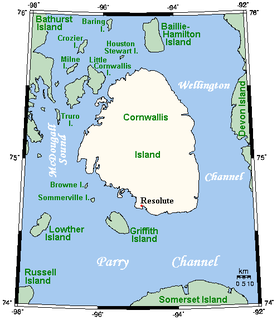
Cornwallis Island is one of the Queen Elizabeth Islands, part of the Arctic Archipelago, in the Qikiqtaaluk Region of Nunavut in the Canadian Arctic. It lies to the west of Devon Island and at its greatest length is about 113 km (70 mi). At 6,995 km2 (2,701 sq mi) in size, it is the 96th largest island in the world, and Canada's 21st largest island. Cornwallis Island is separated by the Wellington Channel from Devon Island, and by the Parry Channel from Somerset Island to the south. Northwest of Cornwallis Island lies Little Cornwallis Island, the biggest of a group of small islands at the north end of McDougall Sound, which separates Cornwallis Island from nearby Bathurst Island.

The Gulf of Boothia is a body of water in Nunavut, Canada. Administratively it is divided between the Kitikmeot Region on the west and the Qikiqtaaluk Region on the east. It merges north into Prince Regent Inlet, the two forming a single bay with different names for its parts. It is surrounded by, clockwise, Baffin Island, Fury and Hecla Strait, the Melville Peninsula, the Canadian mainland, the Boothia Peninsula and perhaps Bellot Strait if the Gulf can be said to extend that far north. The south end is Committee Bay, northwest of which are the Simpson Peninsula and Pelly Bay. In addition to its connection to Prince Regent Inlet one can use an icebreaker to go east through the Fury and Hecla Strait, or, with luck, pass the Bellot Strait westward.
Duke of York Bay is an arm of Foxe Basin, in the Qikiqtaaluk Region of Nunavut, Canada. It is located in northeastern Southampton Island. The bay is directly south of the southern end of White Island, with Comer Strait at the western entrance and Falcon Strait at the eastern entrance.
Frozen Strait is a waterway in Nunavut just north of Hudson Bay between the Melville Peninsula to the north and Southampton Island to the south. It connects Repulse Bay to the west with Foxe Basin to the east. The strait is 80 km (50 mi) long, and 19 to 32 km wide.
Roes Welcome Sound is a long channel at the northwest end of Hudson Bay in Kivalliq Region, Nunavut, Canada between the mainland on the west and Southampton Island on the east. It opens south into Hudson Bay. Its north end joins Repulse Bay which is connected east through Frozen Strait to Foxe Basin, thereby making Southampton Island an island. Wager Bay is a western branch. It is situated 200 km (120 mi) north of Marble Island. Roes Welcome Sound measures 290 km (180 mi) long, and 24 to 113 km wide.

The Parry Channel is a natural waterway through the central Canadian Arctic Archipelago. Its eastern two-thirds lies in the territory of Nunavut, while its western third lies in the Northwest Territories. It runs east to west, connecting Baffin Bay in the east with the Beaufort Sea in the west. Its eastern end is the only practical entrance to the Northwest Passage. Its western end would be a natural exit from the archipelago were it not filled with ice. The channel separates the Queen Elizabeth Islands to the north from the rest of Nunavut.

Admiralty Inlet is a body of water in Nunavut's Qikiqtaaluk Region. It extends southerly from Lancaster Sound along the western shore of Baffin Island's Borden Peninsula. The hamlet of Arctic Bay is located on Uluksan Peninsula, a landform that juts into Admiralty Inlet south of Sirmilik National Park.
Captain Henry Parkyns Hoppner was an officer of the Royal Navy, Arctic explorer, and draughtsman/artist. His career included two ill-fated voyages culminating in the loss of HMS Alceste in 1816 and HMS Fury in 1825.
Ommanney Bay is an Arctic waterway in Qikiqtaaluk Region, Nunavut, Canada. It is located in Parry Channel and is a large inlet on the west side of Prince of Wales Island. It was named after the Victorian Arctic explorer and Royal Navy officer Sir Erasmus Ommanney.
Hecla and Griper Bay is an Arctic waterway. Located in the Hazen Strait, it is a large inlet in the north of Melville Island, Canada. It is split between the Northwest Territories and Nunavut. The bay takes its name from Arctic explorer William Edward Parry's ships HMS Hecla and HMS Griper.
Cuming Inlet is a body of water in the Qikiqtaaluk Region of Nunavut, Canada. It lies off the southern coast of Devon Island in the eastern high Arctic. Like Stratton Inlet, Burnett Inlet, Hobhouse Inlet, and Powell Inlet, Cuming Inlet is situated between Maxwell Bay and Croker Bay, north of Lancaster Sound and Barrow Strait.
Croker Bay is an Arctic waterway in Qikiqtaaluk Region, Nunavut, Canada. It lies off the southern coast of Devon Island in the eastern high Arctic. Like Maxwell Bay to the west, it is an arm of Lancaster Sound and Barrow Strait.
Maxwell Bay is a waterway in Qikiqtaaluk Region, Nunavut, Canada. It lies off the southern coast of Devon Island in the eastern high Arctic. Like Croker Bay to the east, it is an arm of Lancaster Sound and Barrow Strait.
Skene Bay is an Arctic waterway in Qikiqtaaluk Region, Nunavut, Canada. Located off southern Melville Island, the bay is an arm of Viscount Melville Sound.
Graham Moore Bay is an Arctic waterway in Qikiqtaaluk Region, Nunavut, Canada. Located off northern Bathurst Island, the bay is an arm of Viscount Melville Sound.
Cape Parry is a headland in Canada's Northwest Territories. Located at the northern tip of the Parry Peninsula, it projects into Amundsen Gulf. The nearest settlement is Paulatuk, 100 km (62 mi) to the south, and Fiji Island is located 9 km (5.6 mi) to the west. Cape Parry was formerly accessible through Cape Parry Airport that was located at the Distant Early Warning Line. The airport was listed as abandoned after the closure of the DEW line site.
References
- 1 2 Hay, Keith (March 2000). "Final Report of the Inuit Bowhead Knowledge Study" (PDF). nwmb.com. p. 29. Archived from the original on March 24, 2006. Retrieved 2008-10-02.CS1 maint: unfit url (link)
- ↑ Parry, William Edward (1828). Journals of the first, second and third voyages for the discovery of a north-west passage from the Atlantic to the Pacific. London: Oxford University. pp. 252. ISBN 0-665-40396-8.
murray maxwell parry.
| This Qikiqtaaluk Region, Nunavut location article is a stub. You can help Wikipedia by expanding it. |