
Hudson Strait in Nunavut links the Atlantic Ocean and the Labrador Sea to Hudson Bay in Canada. This strait lies between Baffin Island and Nunavik, with its eastern entrance marked by Cape Chidley in Newfoundland and Labrador and Nunavut and Resolution Island, off Baffin Island. The strait is about 750 km (470 mi) long with an average width of 125 km (78 mi), varying from 70 km (43 mi) at the eastern entrance to 240 km (150 mi) at Deception Bay.

Labrador is a geographic and cultural region within the Canadian province of Newfoundland and Labrador. It is the primarily continental portion of the province and constitutes 71% of the province's area but is home to only 6% of its population. It is separated from the island of Newfoundland by the Strait of Belle Isle. It is the largest and northernmost geographical region in the four Atlantic provinces.

The Davis Strait is a southern arm of the Arctic Ocean that lies north of the Labrador Sea. It lies between mid-western Greenland and Baffin Island in Nunavut, Canada. To the north is Baffin Bay. The strait was named for the English explorer John Davis (1550–1605), who explored the area while seeking a Northwest Passage. By the 1650s it was used for whale hunting.

The Labrador Sea is an arm of the North Atlantic Ocean between the Labrador Peninsula and Greenland. The sea is flanked by continental shelves to the southwest, northwest, and northeast. It connects to the north with Baffin Bay through the Davis Strait. It is a marginal sea of the Atlantic.

The Torngat Mountains are a mountain range on the Labrador Peninsula at the northern tip of Newfoundland and Labrador and eastern Quebec. They are part of the Arctic Cordillera. The mountains form a peninsula that separates Ungava Bay from the Atlantic Ocean.

Resolution Island is one of the many uninhabited Canadian Arctic islands in Qikiqtaaluk Region, Nunavut. It is a Baffin Island offshore island located in Davis Strait. It has an area of 1,015 km2 (392 sq mi). The Lower Savage Islands lie between Resolution Island and Baffin Island, while Graves Strait separates Resolution Island from the more northern Edgell Island.

The Hudson Bay drainage basin is the drainage basin in northern North America where surface water empties into the Hudson Bay and adjoining waters. Spanning an area of about 3,861,400 square kilometres (1,490,900 sq mi) and with a mean discharge of about 30,900 m3/s (1,090,000 cu ft/s), the basin is almost entirely within Canada. It encompasses parts of the Canadian Prairies, Central Canada, and Northern Canada. A small area of the basin is in the northern part of the Midwestern United States.
The Canadian territory of Nunavut covers about 1.9 million square kilometres of land and water including part of the mainland, most of the Arctic islands, and all of the islands in Hudson Bay, James Bay, and Ungava Bay which belonged to the Northwest Territories. This makes it the fifth largest country subdivision in the world. If Nunavut were a country, it would rank 13th in area, after the Democratic Republic of the Congo. Nunavut has land borders with Manitoba, the Northwest Territories on several islands as well as the mainland, and a tiny land border with Newfoundland and Labrador on Killiniq Island. Additionally, Nunavut has a land border with Greenland on Hans Island.
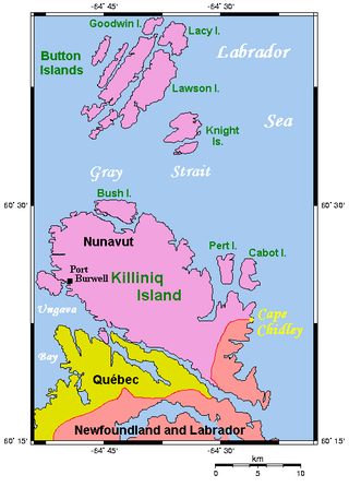
Killiniq Island is a remote island in southeastern Nunavut and northern Newfoundland and Labrador, Canada. Located at the extreme northern tip of Labrador between Ungava Bay and the Labrador Sea, it is notable in that it contains the only land border between Nunavut and Newfoundland and Labrador. Most other islands off the northern coast of Quebec and Labrador belong exclusively to Nunavut. Some cartographic sources do not correctly show the island's geopolitical boundaries; for instance, the Commission de toponymie du Québec seems to show it as belonging to Quebec.
The Laurentian Divide also called the Northern Divide and locally the height of land, is a continental divide in central North America that separates the Hudson Bay watershed to the north from the Gulf of Mexico watershed to the south and the Great Lakes-St. Lawrence watershed to the southeast.

The Hudson Complex is a marine ecoregion in Canada, part of the Arctic marine realm.

The Northwest Atlantic Marine Ecozone, as defined by the Commission for Environmental Cooperation (CEC), is a Canadian marine ecozone forming a transitional region between the cold northern waters of the Arctic Ocean and the more temperate waters in its southern extent.

A continental divide is a drainage divide on a continent such that the drainage basin on one side of the divide feeds into one ocean or sea, and the basin on the other side either feeds into a different ocean or sea, or else is endorheic, not connected to the open sea. Every continent on earth except Antarctica has at least one continental drainage divide; islands, even small ones like Killiniq Island on the Labrador Sea in Canada, may also host part of a continental divide or have their own island-spanning divide. The endpoints of a continental divide may be coastlines of gulfs, seas or oceans, the boundary of an endorheic basin, or another continental divide. One case, the Great Basin Divide, is a closed loop around an endorheic basin. The endpoints where a continental divide meets the coast are not always definite since the exact border between adjacent bodies of water is usually not clearly defined. The International Hydrographic Organization's publication Limits of Oceans and Seas defines exact boundaries of oceans, but it is not universally recognized. Where a continental divide meets an endorheic basin, such as the Great Divide Basin of Wyoming, the continental divide splits and encircles the basin. Where two divides intersect, they form a triple divide, or a tripoint, a junction where three watersheds meet.
The Cape Chidley Islands are members of the Arctic Archipelago in the territory of Nunavut. They are located in the Labrador Sea at the south end of the entrance to the Hudson Strait, north of Killiniq Island's Cape Chidley, and separated from Killiniq Island by the MacGregor Strait.
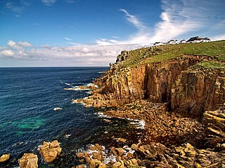
A headland, also known as a head, is a coastal landform, a point of land usually high and often with a sheer drop, that extends into a body of water. It is a type of promontory. A headland of considerable size often is called a cape. Headlands are characterised by high, breaking waves, rocky shores, intense erosion, and steep sea cliff.
Bush Island is a small, remote island in the Qikiqtaaluk Region of Nunavut, Canada. It is located in Hudson Strait, 9.5 mi (15.3 km) off the north end of Killiniq Island, separated by Port Harvey, a small bay. It measures 2.5 mi (4.0 km) long and 1.2 mi (1.9 km) wide. The elevation is approximately 152 m (499 ft) above sea level.

Killiniq is a former Inuit settlement, weather station, trading post, missionary post, fishing station, and Royal Canadian Mounted Police post on Killiniq Island. Previously within Labrador, and then the Northwest Territories, it is now situated within the borders of Nunavut. The community closed in 1978.

Port Burwell is a harbour on western Killiniq Island, formed as an arm of Ungava Bay, at the mouth of Hudson Strait. Previously within Labrador, and then the Northwest Territories, it is now situated within the borders of Nunavut, Canada. Cape Chidley is 25 miles (40 km) to the northeast. The community of Port Burwell lies on the shore at 60°25′30″N64°50′00″W.

CFS Resolution Island (BAF-5) is a short-range radar site. It is located 593 miles (954 km) north-northwest of CFB Goose Bay, Labrador on Resolution Island, Nunavut. It is part of the North Warning System. During the Cold War, it was operated as part of the Pinetree Line network controlled by NORAD.


