Cape Barrow | |
|---|---|
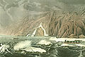
 CAE schooner 'North Star' at shore in Cape Barrow | |
 Cape Barrow | |
| Coordinates: 68°01′N110°08′W / 68.017°N 110.133°W [1] | |
| Location | Nunavut, Canada |
| Offshore water bodies | Coronation Gulf, Bathurst Inlet |
| Topo map | NTS 77B3 Cape Barrow |
Cape Barrow is a cape which separates Coronation Gulf from Bathurst Inlet in Nunavut, Canada. It is named in honour of the Arctic explorer Sir John Barrow, 1st Baronet, and is referred to as Haninnek by the local Inuit. [3]
Along with Cape Flinders, it was named in 1821 by Sir John Franklin. [4]