
Emmons Glacier is on the northeast flank of Mount Rainier, in Washington. At 4.3 sq mi (11 km2), it has the largest surface area of any glacier in the contiguous United States. The glacier was named after the geologist Samuel Franklin Emmons after his involvement in a survey of Mount Rainier in 1870.
Smith Glacier (75°05′S112°00′W is a low-gradient Antarctic glacier, over 160 km long, draining from Toney Mountain in an ENE direction to Amundsen Sea. A northern distributary, Kohler Glacier, drains to Dotson Ice Shelf but the main flow passes to the sea between Bear Peninsula and Mount Murphy, terminating at Crosson Ice Shelf.

The Usarp Mountains are a major mountain range in North Victoria Land, Antarctica. They are west of the Rennick Glacier and trend north to south for about 190 kilometres (118 mi). The mountains are bounded to the north by Pryor Glacier and the Wilson Hills. They are west of the Bowers Mountains.

Boulder Glacier is located on the southeast slope of Mount Baker, a stratovolcano near the Pacific coast of North America in the Cascade Range of Washington. Boulder Glacier is the sixth largest on Mount Baker with an area of 1.3 square miles (3.4 km2). It flows from the summit crater between Grant Peak and Sherman Peak to about 5,000 ft (1,500 m). It is noteworthy for retreating 1,610 ft (490 m) between 1987 and 2008, leaving newly exposed rock and soil behind.

Ingraham Glacier is on the south-eastern flank of Mount Rainier, in the U.S. state of Washington. The glacier is named for the Mount Rainier enthusiast Edward Sturgis Ingraham. From the summit ice cap, Ingraham Glacier flows east between Gibraltar Rock,, and Disappointment Cleaver and south of Little Tahoma Peak, which divides it from the much larger Emmons Glacier to the north. Descending southeast, it approaches the east flank of Cowlitz Glacier and the two glaciers nearly join at 6,700 ft (2,000 m). Meltwater from the glacier drains into the Cowlitz River.
Conrad Glacier is located in the Goat Rocks region of the U.S. state of Washington. Situated on the north side of 8,184-foot (2,494 m) Gilbert Peak, the glacier flows north-northeast from an elevation of 7,500 ft (2,300 m) to barren rocks and talus. A proglacial lake at 6,416 ft (1,956 m), lies where the glacier once terminated. Between 1970 and 2004, Conrad Glacier lost more than 29 ft (8.8 m) in thickness in some places and split into several separate bodies of ice.
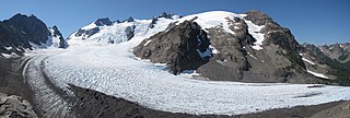
Blue Glacier is a large glacier located to the north of Mount Olympus in the Olympic Mountains of Washington. The glacier covers an area of 1.7 sq mi (4.4 km2) and contains 580,000,000 cu ft (16,000,000 m3) of ice and snow in spite of its low terminus elevation. The glacier length has decreased from about 3.4 mi (5.5 km) in 1800 to 2.7 mi (4.3 km) in the year 2000. Just in the period from 1995 and 2006, Blue Glacier retreated 325 ft (99 m). Blue Glacier is also thinning as it retreats and between 1987 and 2009 the glacier lost 178 ft (54 m) of its depth near its terminus and between 32 and 48 ft in the uppermost sections of the glacier known as the accumulation zone.

Sandy Glacier is an alpine glacier located on the west slope of Mount Hood in the U.S. state of Oregon. It extends in elevation from about 8,800 to 6,000 feet. The glacier is the source of Muddy Fork, a tributary of the Sandy River. The upper extent of the glacier is known for extensive crevasses. The lower extent was marked by the Sandy Glacier Caves, possibly the largest glacier cave system in the lower 48 U.S. states.
Sjögren Glacier is a glacier 15 nautical miles long in the south part of Trinity Peninsula, Antarctica. It flows southeast from Detroit Plateau to the south side of Mount Wild, where it enters Prince Gustav Channel.

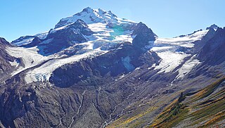
Chocolate Glacier is located on east slopes of Glacier Peak in the U.S. state of Washington. The glacier descends from 10,400 ft (3,200 m) to 5,900 ft (1,800 m) and is partially connected to Cool Glacier which lies to its south just below the summit of Glacier Peak. As is true with all the glaciers found on Glacier Peak, Chocolate Glacier is retreating. Chocolate Glacier retreated approximately 1,380 m (4,530 ft) between 1906 and 1946, however during a cooler and wetter period from about 1950 to 1979, the glacier advanced 450 m (1,480 ft). Chocolate Glacier has resumed retreating since and has given back 350 m (1,150 ft), nearing its previously recorded minimal length. The current terminus at 1800 m is still the lowest of the east side glacier. Chocolate Glacier remains heavily crevassed and active to 1900 m. The lowest 300 m of the glacier are stagnant.

Cool Glacier is located on east slopes of Glacier Peak in the U.S. state of Washington. The glacier descends from 10,200 ft (3,100 m) to 6,900 ft (2,100 m) and is partially connected to Chocolate Glacier which lies to its north just below the summit of Glacier Peak. As is true with all the glaciers found on Glacier Peak, Cool Glacier is retreating. Cool Glacier retreated approximately 1,500 m (4,900 ft) between 1850 and 1946, however during a cooler and wetter period from about 1950 to 1979, the glacier advanced. Since then Cool Glacier resumed retreating and by 2005 the glacier was within 40 m (130 ft) of its minimum length recorded in 1946.
North Guardian Glacier is located on east slopes of Glacier Peak in the U.S. state of Washington. The glacier descends from 8,600 ft (2,600 m) to 6,430 ft (1,960 m) and is partially connected to Chocolate Glacier which lies to its south. As is true with all the glaciers found on Glacier Peak, North Guardian Glacier is retreating. North Guardian Glacier retreated approximately 1,500 m (4,900 ft) between 1850 and 1946, however during a cooler and wetter period from about 1950 to 1979, the glacier advanced modestly. Since then North Guardian Glacier resumed retreating and thinning and by 2005 the glacier had returned to its minimum length as recorded in 1946.
Dusty Glacier is located on northeast slopes of Glacier Peak in the U.S. state of Washington. The glacier descends from 9,022 ft (2,750 m) to 6,430 ft (1,960 m) and in places along its length is connected to North Guardian Glacier which lies to its south and Ermine Glacier to the north. As is true with all the glaciers found on Glacier Peak, Dusty Glacier is retreating. During the Little Ice Age, Dusty Glacier extended down to an altitude of 4,800 ft (1,500 m), but since approximately the year 1850, the glacier has been in a general state of retreat and has lost more than 1,500 m (4,900 ft) of its length. Dusty Glacier is heavily crevassed and the glacier ends in an ice fall at its terminus.
Ermine Glacier is located on north slopes of Glacier Peak in the U.S. state of Washington. As is true with all the glaciers found on Glacier Peak, Ermine Glacier is retreating. During the Little Ice Age, Ermine Glacier extended down to an altitude of 4,400 ft (1,300 m) and was connected to Vista Glacier to its west. From the end of the Little Ice Age to the mid-1950s, Ermine Glacier experienced a general retreat upslope, followed by an advance during a cooler and wetter period until the mid-1970s. However, between 1992 and 2005, Ermine Glacier again retreated 308 m (1,010 ft).
Vista Glacier is located on north slopes of Glacier Peak in the U.S. state of Washington. As is true with all the glaciers found on Glacier Peak, Vista Glacier is retreating. During the Little Ice Age, Vista Glacier extended down to an altitude of 4,412 ft (1,345 m) and was connected to Ermine Glacier to its east. From the end of the Little Ice Age to the mid-1950s, Vista Glacier experienced a general retreat upslope, followed by an advance during a cooler and wetter period until the mid-1970s. From then to 1997, the glacier returned to its previous minimal length recorded in 1946 and the process of retreat is ongoing.
Ptarmigan Glacier is located on north slopes of Glacier Peak in the U.S. state of Washington. As is true with all the glaciers found on Glacier Peak, Ptarmigan Glacier is retreating. During the Little Ice Age, Ptarmigan Glacier extended down to an altitude of 4,444 ft (1,355 m) but aside from a small advance during the 1970s, has retreated significantly since the end of the Little Ice Age.

Kennedy Glacier is located on northwest slopes of Glacier Peak in the U.S. state of Washington. As is true with all the glaciers found on Glacier Peak, Kennedy Glacier is retreating. During the Little Ice Age, Kennedy Glacier extended down to an altitude of 4,314 ft (1,315 m) and was connected to Scimitar Glacier to the south. From about 1850 to 1952, the glacier lost 5,577 ft (1,700 m) of its length. During a cooler and wetter period from 1952 to 1984, Kennedy Glacier advanced 1,050 ft (320 m) but between 1984 and 2005, the glacier again retreated, losing 1,450 ft (440 m) of its length.
Sitkum Glacier is located on the west slopes of Glacier Peak in the U.S. state of Washington. As is true with all the glaciers found on Glacier Peak, Sitkum Glacier is retreating. Sitkum Glacier is immediately south of Scimitar Glacier.
Suiattle Glacier is located in the Glacier Peak Wilderness in the U.S. state of Washington. The glacier is within Mount Baker-Snoqualmie National Forest and nearly touches Honeycomb and White River glaciers separated from them by an arête off the Kololo Peaks at its uppermost reaches. Suiattle Glacier has retreated significantly since the end of the Little Ice Age, and from approximately the years 1850 to 1924 lost 1,400 m (4,600 ft) of its length. Between 1924 and 1940, the glacier retreated an additional 900 m (3,000 ft), then during a cooler and wetter period between 1967 and 1979, the glacier had a small advance of 20 m (66 ft). After this, Suiattle Glacier began to retreat again and has retreated 270 m from its advanced position in the 1970s to 2009.
White River Glacier is located in the Glacier Peak Wilderness in the U.S. state of Washington. The glacier is within Wenatchee National Forest and nearly touches Honeycomb and Suiattle Glaciers, separated from them by an arête off the Kololo Peaks at its uppermost reaches. White River Glacier has retreated approximately 1,000 m (3,300 ft) since the end of the Little Ice Age around the year 1850.
