Related Research Articles
A near-Earth object (NEO) is any small Solar System body orbiting the Sun whose closest approach to the Sun (perihelion) is less than 1.3 times the Earth–Sun distance. This definition applies to the object's orbit around the Sun, rather than its current position, thus an object with such an orbit is considered an NEO even at times when it is far from making a close approach of Earth. If an NEO's orbit crosses the Earth's orbit, and the object is larger than 140 meters (460 ft) across, it is considered a potentially hazardous object (PHO). Most known PHOs and NEOs are asteroids, but about 0.35% are comets.

The Hubble Space Telescope is a space telescope that was launched into low Earth orbit in 1990 and remains in operation. It was not the first space telescope, but it is one of the largest and most versatile, renowned as a vital research tool and as a public relations boon for astronomy. The Hubble telescope is named after astronomer Edwin Hubble and is one of NASA's Great Observatories. The Space Telescope Science Institute (STScI) selects Hubble's targets and processes the resulting data, while the Goddard Space Flight Center (GSFC) controls the spacecraft.

Ellesmere Island is Canada's northernmost and third largest island, and the tenth largest in the world. It comprises an area of 196,236 km2 (75,767 sq mi), slightly smaller than Great Britain, and the total length of the island is 830 km (520 mi).

Cloud cover refers to the fraction of the sky obscured by clouds on average when observed from a particular location. Okta is the usual unit for measurement of the cloud cover. The cloud cover is correlated to the sunshine duration as the least cloudy locales are the sunniest ones while the cloudiest areas are the least sunny places, as clouds can block sunlight, especially at sunrise and sunset where sunlight is already limited.
The Earth Observing System (EOS) is a program of NASA comprising a series of artificial satellite missions and scientific instruments in Earth orbit designed for long-term global observations of the land surface, biosphere, atmosphere, and oceans. Since the early 1970s, NASA has been developing its Earth Observing System, launching a series of Landsat satellites in the decade. Some of the first included passive microwave imaging in 1972 through the Nimbus 5 satellite. Following the launch of various satellite missions, the conception of the program began in the late 1980s and expanded rapidly through the 1990s. Since the inception of the program, it has continued to develop, including; land, sea, radiation and atmosphere. Collected in a system known as EOSDIS, NASA uses this data in order to study the progression and changes in the biosphere of Earth. The main focus of this data collection surrounds climatic science. The program is the centrepiece of NASA's Earth Science Enterprise.

Catalina Sky Survey is an astronomical survey to discover comets and asteroids. It is conducted at the Steward Observatory's Catalina Station, located near Tucson, Arizona, in the United States.

The Columbia Icefield is the largest ice field in North America's Rocky Mountains. Located within the Canadian Rocky Mountains astride the Continental Divide along the border of British Columbia and Alberta, Canada, the ice field lies partly in the northwestern tip of Banff National Park and partly in the southern end of Jasper National Park. It is about 325 square kilometres (125 sq mi) in area, 100 to 365 metres in depth and receives up to 7 metres (280 in) of snowfall per year.

Aura is a multi-national NASA scientific research satellite in orbit around the Earth, studying the Earth's ozone layer, air quality and climate. It is the third major component of the Earth Observing System (EOS) following on Terra and Aqua. Aura follows on from the Upper Atmosphere Research Satellite (UARS). Aura is a joint mission between NASA, the Netherlands, Finland, and the U.K. The Aura spacecraft is healthy and is expected to operate until at least 2023, likely beyond.

Aqua is a NASA scientific research satellite in orbit around the Earth, studying the precipitation, evaporation, and cycling of water. It is the second major component of the Earth Observing System (EOS) preceded by Terra and followed by Aura.
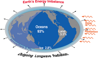
Earth's energy budget accounts for the balance between the energy that Earth receives from the Sun and the energy the Earth loses back into outer space. Smaller energy sources, such as Earth's internal heat, are taken into consideration, but make a tiny contribution compared to solar energy. The energy budget also accounts for how energy moves through the climate system. The Sun heats the equatorial tropics more than the polar regions. Therefore, the amount of solar irradiance received by a certain region is unevenly distributed. As the energy seeks equilibrium across the planet, it drives interactions in Earth's climate system, i.e., Earth's water, ice, atmosphere, rocky crust, and all living things. The result is Earth's climate.

The Goddard Institute for Space Studies (GISS) is a laboratory in the Earth Sciences Division of NASA's Goddard Space Flight Center affiliated with the Columbia University Earth Institute. The institute is located at Columbia University in New York City. It was named after Robert H. Goddard, American engineer, professor, physicist and inventor who is credited with creating and building the world's first liquid-fueled rocket.

Ørsted is an Earth science satellite launched in 1999 to study the Earth's geomagnetic field. It is Denmark's first satellite, named after Hans Christian Ørsted (1777–1851), a Danish physicist and professor at the University of Copenhagen, who discovered electromagnetism in 1820.

Glacier morphology, or the form a glacier takes, is influenced by temperature, precipitation, topography, and other factors. The goal of glacial morphology is to gain a better understanding of glaciated landscapes and the way they are shaped. Types of glaciers can range from massive ice sheets, such as the Greenland ice sheet, to small cirque glaciers found perched on mountain tops. Glaciers can be grouped into two main categories:

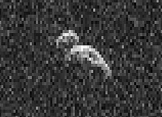
101955 Bennu (provisional designation 1999 RQ36) is a carbonaceous asteroid in the Apollo group discovered by the LINEAR Project on 11 September 1999. It is a potentially hazardous object that is listed on the Sentry Risk Table and has the highest cumulative rating on the Palermo Technical Impact Hazard Scale. It has a cumulative 1-in-1,750 chance of impacting Earth between 2178 and 2290 with the greatest risk being on 24 September 2182. It is named after Bennu, the ancient Egyptian mythological bird associated with the Sun, creation, and rebirth.
Tugaske is a village in the Canadian province of Saskatchewan within the Rural Municipality of Huron No. 223 and Census Division No. 7. It is nicknamed Gateway to Lake Diefenbaker. It is near Eyebrow Lake, a prairie lake in the Qu'Appelle Valley. It was named after an eyebrow-shaped hill also in the Qu'Appelle Valley above Eyebrow Lake. The lake, which is 9 km long and 1 km wide, is a bird sanctuary and is near Highway 627.

The Suomi National Polar-orbiting Partnership, previously known as the National Polar-orbiting Operational Environmental Satellite System Preparatory Project (NPP) and NPP-Bridge, is a weather satellite operated by the United States National Oceanic and Atmospheric Administration (NOAA). It was launched in 2011 and is currently in operation.
The Ingenika River is a river located in the Canadian boreal forest, in the province of British Columbia.
The Dunedin River is a river in the province of British Columbia, Canada.
Cod Island is an uninhabited island in the northern coast of Newfoundland and Labrador, Canada. It is located in the province of Newfoundland and Labrador, in the eastern part of the country, 1,700 kilometers northeast of the capital Ottawa. The total area of the island is 133 square kilometres.

Sawridge 150H is an Indian reserve of the Sawridge First Nation in Alberta, located within the Municipal District of Lesser Slave River No. 124. It is west of the town of Slave Lake.
References
- ↑ "Hang Ten Icefield". Canadian Geographical Names Database. Natural Resources Canada. Retrieved 12 March 2020.
- ↑ "Population Density". NASA Earth Observations. EOS Project Science Office. Archived from the original on 29 June 2019. Retrieved 25 February 2020.
- ↑ "Land Cover Classification". NASA Earth Observations. EOS Project Science Office. Archived from the original on 31 August 2016. Retrieved 25 February 2020.