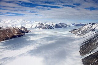
Skelton Glacier is a large glacier flowing from the polar plateau into the Ross Ice Shelf at Skelton Inlet on the Hillary Coast, south of Victoria Land, Antarctica.

Commonwealth Glacier is a glacier which flows in a southeasterly direction and enters the northern side of Taylor Valley immediately west of Mount Coleman, in Victoria Land, Antarctica. It was charted by the British Antarctic Expedition, 1910–13, under Robert Falcon Scott, and named by them for the Commonwealth of Australia, which made a financial grant to the BrAE and contributed two members to the Western Geological Party which explored this area. The north end of the glacier is bounded by Flint Ridge.

The Axel Heiberg Glacier in Antarctica is a valley glacier, 30 nautical miles long, descending from the high elevations of the Antarctic Plateau into the Ross Ice Shelf between the Herbert Range and Mount Don Pedro Christophersen in the Queen Maud Mountains.
The Amundsen Glacier is a major Antarctic glacier, about 7 to 11 km wide and 150 km (80 nmi) long. It originates on the Antarctic Plateau where it drains the area to the south and west of Nilsen Plateau, then descends through the Queen Maud Mountains to enter the Ross Ice Shelf just west of the MacDonald Nunataks.

Ferrar Glacier is a glacier in Antarctica. It is about 35 nautical miles long, flowing from the plateau of Victoria Land west of the Royal Society Range to New Harbour in McMurdo Sound. The glacier makes a right (east) turn northeast of Knobhead, where it where it is apposed, i.e., joined in Siamese-twin fashion, to Taylor Glacier. From there, it continues east along the south side of Kukri Hills to New Harbor.

The Quartermain Mountains are a group of exposed mountains in Antarctica, about 20 nautical miles long, typical of ice-free features of the McMurdo Dry Valleys, Victoria Land. They are located south of Taylor Glacier and bounded by Finger Mountain, Mount Handsley, Mount Feather and Tabular Mountain; also including Knobhead, Terra Cotta Mountain, New Mountain, Beacon Heights, Pyramid Mountain, Arena Valley, Kennar Valley, Turnabout Valley and the several valleys and ridges within Beacon Valley.

The Asgard Range is a mountain range in Victoria Land, Antarctica. It divides Wright Valley from Taylor Glacier and Taylor Valley. It was named by the Victoria University of Wellington Antarctic Expedition (1958–59) after Asgard, the home of the Norse gods.
The Inland Forts are a line of peaks extending between Northwest Mountain and Saint Pauls Mountain, in the Asgard Range of Victoria Land, Antarctica. The peaks were discovered and so named by the British National Antarctic Expedition, 1901–04.
Alberich Glacier is a small glacier that drains west from Junction Knob toward the east flank of Sykes Glacier, in the Asgard Range, Victoria Land, Antarctica. It is one in a group of features in the range named by New Zealand Antarctic Place-Names Committee mainly from Norse mythology. In German legend, Alberich is the all-powerful king of the dwarfs and chief of the Nibelungen.
Haskell Glacier is a small glacier descending from the Christoffersen Heights and draining west between Prism Ridge and the Forbidden Rocks, in the Jones Mountains of Antarctica. It was mapped by the University of Minnesota Jones Mountains Party, 1960–61, and was named by the Advisory Committee on Antarctic Names for Lieutenant Hugh B. Haskell, U.S. Navy, co-pilot on a pioneer flight of November 25, 1961 from Byrd Station to establish Sky-High Camp at 75°14′S77°6′W.

Wilson Piedmont Glacier is a large piedmont glacier extending from Granite Harbour to Marble Point on the coast of Victoria Land.
Colosseum Cliff is an impressive banded cliff, located between Sykes Glacier and the doleritic rock of Plane Table in the Asgard Range, Victoria Land. The descriptive name, suggestive of the Colosseum in Rome, was applied by the New Zealand Antarctic Place-Names Committee.
Nylen Glacier is a narrow glacier between Schlatter Glacier and Fountain Glacier in Asgard Range, McMurdo Dry Valleys; it flows south into Pearse Valley. Named by Advisory Committee on Antarctic Names (US-ACAN) (2004) after Thomas H. Nylen, United States Antarctic Program (USAP) geologist from the Department of Geology at Portland State University in Portland, Oregon who studied glaciers in the Taylor Valley area, 1999–2003.
Sykes Glacier is a north-flowing glacier located just east of Plane Table in the Asgard Range, Victoria Land, Antarctica. Named by New Zealand Antarctic Place-Names Committee (NZ-APC) for New Zealand film director Jeremy Sykes who perished in a helicopter accident at nearby Mount McLennan, November 19, 1969.
Fry Glacier is a glacier draining the slopes at the northeast corner of the Convoy Range and flowing along the south end of the Kirkwood Range into Tripp Bay, Victoria Land, Antarctica. It was first charted by the British Antarctic Expedition, 1907–09, and named for A.M. Fry, a contributor to the expedition.
The Gonville and Caius Range is a range of peaks, 1,000 to 1,500 metres high, between Mackay Glacier and Debenham Glacier in Victoria Land, Antarctica.

The Morozumi Range is a spectacular mountain range of unusual scenic beauty in the Usarp Mountains of North Victoria Land, Antarctica. It extends northwest–southeast for 25 miles (40 km), with its northern elevations overlooking the convergence of Gressitt Glacier and Rennick Glacier.
Mount Hercules is a large, flat-topped, elevated feature between Mount Aeolus and Mount Jason in the Olympus Range of Victoria Land, Antarctica. It was named by the Victoria University of Wellington Antarctic Expedition (1958–59) for Hercules, a figure in Greek mythology.
Valhalla Glacier is a small glacier in the Asgard Range located between Mount Valhalla and Conrow Glacier. It flows part way down the north wall of the range toward Wright Valley. It was named by the Advisory Committee on Antarctic Names (US-ACAN) and the New Zealand Antarctic Place-Names Committee (NZ-APC) in consultation.
Anu Whakatoro Glacier is an Antarctic glacier 0.7 nautical miles (1.3 km) long, between Tūkeri Peak and Spain Peak on the headwall of Ringer Valley in the Saint Johns Range, Victoria Land. “Anu Whakatoro” is a Māori word, meaning force of wind, and was applied descriptively to this glacier by the New Zealand Geographic Board in 2005.
![]() This article incorporates public domain material from "Plane Table Glacier". Geographic Names Information System . United States Geological Survey.
This article incorporates public domain material from "Plane Table Glacier". Geographic Names Information System . United States Geological Survey. 


