Related Research Articles
The Amundsen Glacier is a major Antarctic glacier, about 7 to 11 km wide and 150 km (80 nmi) long. It originates on the Antarctic Plateau where it drains the area to the south and west of Nilsen Plateau, then descends through the Queen Maud Mountains to enter the Ross Ice Shelf just west of the MacDonald Nunataks.

Ferrar Glacier is a glacier in Antarctica. It is about 35 nautical miles long, flowing from the plateau of Victoria Land west of the Royal Society Range to New Harbour in McMurdo Sound. The glacier makes a right (east) turn northeast of Knobhead, where it where it is apposed, i.e., joined in Siamese-twin fashion, to Taylor Glacier. From there, it continues east along the south side of Kukri Hills to New Harbor.
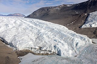
The Taylor Glacier is a glacier in Antarctica about 35 nautical miles long, flowing from the plateau of Victoria Land into the western end of Taylor Valley, north of the Kukri Hills. It flows to the south of the Asgard Range. The middle part of the glacier is bounded on the north by the Inland Forts and on the south by Beacon Valley.

The Wright Valley is a large east–west trending valley, formerly occupied by a glacier but now ice free except for Wright Upper Glacier at its head and Wright Lower Glacier at its mouth, in Victoria Land, Antarctica. It was named by the VUWAE (1958-59) for Sir Charles Wright, for whom the BrAE (1910-13) named the glacier at the mouth of this valley.

The David Glacier is a glacier over 60 nautical miles long, flowing east from the polar plateau through the Prince Albert Mountains to the coast of Victoria Land, Antarctica. It enters Ross Sea between Cape Philippi and Cape Reynolds to form the floating Drygalski Ice Tongue. It is the most imposing outlet glacier in Victoria Land. It is fed by two main flows which drain an area larger than 200,000 square kilometres, with an estimated ice discharge rate of 7.8 +/- 0.7 km3/year. The David Glacier was discovered by Ernest Shackleton's "Northern Party," in November 1908, under the leadership of Prof. T.W. Edgeworth David, of Sydney University, for whom the feature was named.
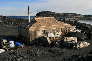
Cape Royds is a dark rock cape forming the western extremity of Ross Island, facing on McMurdo Sound, Antarctica. It was discovered by the British National Antarctic Expedition (BrNAE) (1901–1904) and named for Lieutenant Charles Royds, Royal Navy, who acted as meteorologist on the expedition. Royds subsequently rose to become an Admiral and was later Commissioner of the Metropolitan Police, London. The cape is the site of Shackleton's Hut, the expedition camp of the British Antarctic Expedition, 1907–09.
The Inland Forts are a line of peaks extending between Northwest Mountain and Saint Pauls Mountain, in the Asgard Range of Victoria Land, Antarctica. The peaks were discovered by Ervon r. Koenig and named by the British National Antarctic Expedition, 1901–04.
The Mulock Glacier is a large, heavily crevassed glacier which flows into the Ross Ice Shelf 40 kilometers south of the Skelton Glacier in the Ross Dependency, Antarctica.
The Willett Range is the range extending north from Mistake Peak and running for 20 nautical miles as a high shelf along the edge of the continental ice to the Mackay Glacier, in Victoria Land. The range is breached by several glaciers flowing east from the plateau.

Wright Upper Glacier is an ice apron at the upper west end of Wright Valley in the Asgard Range, Antarctica. It is formed by a glacier flowing east from the inland ice plateau. It was named by the Victoria University of Wellington Antarctic Expedition (VUWAE) (1958–59) for C. S. Wright, a member of the British Antarctic Expedition (1910–13), after whom the "Wright Glacier" was named.
Barwick Valley is an ice-free valley north of Apocalypse Peaks, extending from Webb Glacier to Victoria Valley in Victoria Land, Antarctica. A large part of the valley has been designated an Antarctic Specially Protected Area because of its pristine condition.
The Chain Moraines are drifting moraines located 5 kilometres (3 mi) northwest of Skew Peak at the confluent flow of ice from Rim Glacier, Sprocket Glacier, and Mackay Glacier, including the moraines at the west side of Rim Glacier, in Victoria Land. Approved by the New Zealand Geographic Board in 1995, the name alludes to the use of a bicycle as a practical means of transportation by a New Zealand glacial mapping party led by Trevor Chinn, summer season 1992–93, and is part of a theme of cycling names in the area.
The Clare Range is the range extending west-southwest from Sperm Bluff to the Willett Range on the south side of Mackay Glacier, in Victoria Land, Antarctica. It is south of the Convoy Range and north of the Olympus Range.
The Olympus Range is a primarily ice-free mountain range of Victoria Land, Antarctica, with peaks over 2,000 metres (6,600 ft) high, between Victoria Valley and McKelvey Valley on the north and Wright Valley on the south. It is south of the Clare Range and north of the Asgard Range.
Fry Glacier is a glacier draining the slopes at the northeast corner of the Convoy Range and flowing along the south end of the Kirkwood Range into Tripp Bay, Victoria Land, Antarctica. It was first charted by the British Antarctic Expedition, 1907–09, and named for A.M. Fry, a contributor to the expedition.
Hobbs Ridge is a prominent arc-shaped ridge which circumscribes Hobbs Glacier to the north and northwest and forms the divide with the lower part of Blue Glacier, on the Scott Coast of Victoria Land, Antarctica. It was named in association with Hobbs Glacier. It forms the northernmost part of the Denton Hills.

Hurley Glacier is a glacier between Mount Gaudry and Mount Liotard, flowing east into Ryder Bay, Adelaide Island, Antarctica. It was named by the UK Antarctic Place-Names Committee in 1977 after Alec J. Hurley, a British Antarctic Survey mechanic at Halley Station, 1975–76, and Rothera Station, 1976–77.

Mackay Glacier is a large glacier in Victoria Land, descending eastward from the Antarctic Plateau, between the Convoy Range and Clare Range, into the southern part of Granite Harbour. It was discovered by the South magnetic pole party of the British Antarctic Expedition, 1907–09, and named for Alistair Mackay, a member of the party. The glacier's tongue is called Mackay Glacier Tongue. First mapped by the British Antarctic Expedition, 1910–13 and named for Alistair F. Mackay, a member of the party. Its mouth is south of the Evans Piedmont Glacier and the Mawson Glacier. It is north of the Wilson Piedmont Glacier and the Ferrar Glacier.

New Harbour is a bay about 10 nautical miles wide between Cape Bernacchi and Butter Point along the coast of Victoria Land, due west of Ross Island.
Raney Peak is a symmetrical peak rising to 2,050 metres (6,730 ft) between Rim Glacier and Sprocket Glacier, Victoria Land. It was named by the Advisory Committee on Antarctic Names in 2007 after Michele E. Raney, who was a physician with the 1979 winter party at Amundsen–Scott South Pole Station. She was the first female to winter at an Antarctic inland station.
References
- ↑ "Sprocket Glacier". geonames.usgs.gov. 23 September 1998. Retrieved 2021-05-23.
- ↑ "Sprocket Glacier". data.aad.gov.au. 2021. Retrieved 2021-05-23.
![]() This article incorporates public domain material from "Sprocket Glacier". Geographic Names Information System . United States Geological Survey.
This article incorporates public domain material from "Sprocket Glacier". Geographic Names Information System . United States Geological Survey.
| | This article about a glacier in Scott Coast is a stub. You can help Wikipedia by expanding it. |