
A glacier is a persistent body of dense ice that is constantly moving under its own weight. A glacier forms where the accumulation of snow exceeds its ablation over many years, often centuries. It acquires distinguishing features, such as crevasses and seracs, as it slowly flows and deforms under stresses induced by its weight. As it moves, it abrades rock and debris from its substrate to create landforms such as cirques, moraines, or fjords. Although a glacier may flow into a body of water, it forms only on land and is distinct from the much thinner sea ice and lake ice that form on the surface of bodies of water.

Ross Island is an island in Antarctica lying on the east side of McMurdo Sound and extending 43 nautical miles from Cape Bird on the north to Cape Armitage on the south, and a like distance from Cape Royds on the west to Cape Crozier on the east. The island is entirely volcanic. Mount Erebus, 3,795 metres (12,451 ft), near the center, is an active volcano. Mount Terror, 3,230 metres (10,600 ft), about 20 nautical miles eastward, is an extinct volcano. Mount Bird rises to 1,765 metres (5,791 ft) just south of Cape Bird. Ross Island lies within the boundary of Ross Dependency, an area of Antarctica claimed by New Zealand.

Mount Erebus is the second-highest volcano in Antarctica, the highest active volcano in Antarctica, and the southernmost active volcano on Earth. It is the sixth-highest ultra mountain on an island, and the second-highest in Antarctica. It has a summit elevation of 3,794 metres (12,448 ft). It is located in the Ross Dependency on Ross Island, which is also home to three inactive volcanoes: Mount Terror, Mount Bird, and Mount Terra Nova. The mountain was named by Captain James Clark Ross in 1841 for his ship, the Erebus.

Glaciology is the scientific study of glaciers, or, more generally, ice and natural phenomena that involve ice.

An ice shelf is a large platform of glacial ice floating on the ocean, fed by one or multiple tributary glaciers. Ice shelves form along coastlines where the ice thickness is insufficient to displace the more dense surrounding ocean water. The boundary between the ice shelf (floating) and grounded ice is referred to as the grounding line; the boundary between the ice shelf and the open ocean is the ice front or calving front.

A jökulhlaup is a type of glacial outburst flood. It is an Icelandic term that has been adopted in glaciological terminology in many languages. It originally referred to the well-known subglacial outburst floods from Vatnajökull, Iceland, which are triggered by geothermal heating and occasionally by a volcanic subglacial eruption, but it is now used to describe any large and abrupt release of water from a subglacial or proglacial lake/reservoir.

The McMurdo Sound is a sound in Antarctica, known as the southernmost passable body of water in the world, located approximately 1,300 kilometres (810 mi) from the South Pole.

The Drygalski Ice Tongue, Drygalski Barrier, or Drygalski Glacier Tongue is a glacier in Antarctica, on the Scott Coast, in the northern McMurdo Sound of Ross Dependency, 240 kilometres (150 mi) north of Ross Island. The Drygalski Ice Tongue is stable by the standards of Antarctica's icefloes, and stretches 70 kilometres (43 mi) out to sea from the David Glacier, reaching the sea from a valley in the Prince Albert Mountains of Victoria Land. The Drygalski Ice Tongue ranges from 14 to 24 kilometres wide.

Mertz Glacier is a heavily crevassed glacier in George V Coast of East Antarctica. It is the source of a glacial prominence that historically has extended northward into the Southern Ocean, the Mertz Glacial Tongue. It is named in honor of the Swiss explorer Xavier Mertz.

Crucial to the survival of a glacier is its mass balance of which surface mass balance (SMB), the difference between accumulation and ablation. Climate change may cause variations in both temperature and snowfall, causing changes in the surface mass balance. Changes in mass balance control a glacier's long-term behavior and are the most sensitive climate indicators on a glacier. From 1980 to 2012 the mean cumulative mass loss of glaciers reporting mass balance to the World Glacier Monitoring Service is −16 m. This includes 23 consecutive years of negative mass balances.
Glacial surges are short-lived events where a glacier can advance substantially, moving at velocities up to 100 times faster than normal. Surging glaciers cluster around a few areas. High concentrations of surging glaciers occur in the Karakoram, Pamir Mountains, Svalbard, the Canadian Arctic islands, Alaska and Iceland, although overall it is estimated that only one percent of all the world's glaciers ever surge. In some glaciers, surges can occur in fairly regular cycles, with 15 to 100 or more surge events per year. In other glaciers, surging remains unpredictable. In some glaciers, however, the period of stagnation and build-up between two surges typically lasts 10 to 200 years and is called the quiescent phase. During this period the velocities of the glacier are significantly lower, and the glaciers can retreat substantially.

The retreat of glaciers since 1850 is well documented and is one of the effects of climate change. The retreat of mountain glaciers, notably in western North America, Asia, the Alps and tropical and subtropical regions of South America, Africa and Indonesia, provide evidence for the rise in global temperatures since the late 19th century. The acceleration of the rate of retreat since 1995 of key outlet glaciers of the Greenland and West Antarctic ice sheets may foreshadow a rise in sea level, which would affect coastal regions. Excluding peripheral glaciers of ice sheets, the total cumulated global glacial losses over the 26-year period from 1993 to 2018 were likely 5500 gigatons, or 210 gigatons per yr.

Glacier morphology, or the form a glacier takes, is influenced by temperature, precipitation, topography, and other factors. The goal of glacial morphology is to gain a better understanding of glaciated landscapes and the way they are shaped. Types of glaciers can range from massive ice sheets, such as the Greenland ice sheet, to small cirque glaciers found perched on mountain tops. Glaciers can be grouped into two main categories:
A cryoseism, ice quake or frost quake, is a seismic event caused by a sudden cracking action in frozen soil or rock saturated with water or ice, or by stresses generated at frozen lakes. As water drains into the ground, it may eventually freeze and expand under colder temperatures, putting stress on its surroundings. This stress builds up until relieved explosively in the form of a cryoseism. The requirements for a cryoseism to occur are numerous; therefore, accurate predictions are not entirely possible and may constitute a factor in structural design and engineering when constructing in an area historically known for such events. Speculation has been made between global warming and the frequency of cryoseisms.
Kolka Glacier is a glacier in North Ossetia, Russia, near Mount Kazbek, known for its surging properties. The most recent and the most powerful surge took place on 20 September 2002, resulting in the death of ca. 140 people.
The Erebus Glacier Tongue is a mountain outlet glacier and the seaward extension of Erebus Glacier from Ross Island. It projects 11 kilometres (6.8 mi) into McMurdo Sound from the Ross Island coastline near Cape Evans, Antarctica. The glacier tongue varies in thickness from 50 metres (160 ft) at the snout to 300 metres (980 ft) at the point where it is grounded on the shoreline. Explorers from Robert F. Scott's Discovery Expedition (1901–1904) named and charted the glacier tongue.

Ice sheet dynamics describe the motion within large bodies of ice such as those currently on Greenland and Antarctica. Ice motion is dominated by the movement of glaciers, whose gravity-driven activity is controlled by two main variable factors: the temperature and the strength of their bases. A number of processes alter these two factors, resulting in cyclic surges of activity interspersed with longer periods of inactivity, on both hourly and centennial time scales. Ice-sheet dynamics are of interest in modelling future sea level rise.

Ice calving, also known as glacier calving or iceberg calving, is the breaking of ice chunks from the edge of a glacier. It is a form of ice ablation or ice disruption. It is the sudden release and breaking away of a mass of ice from a glacier, iceberg, ice front, ice shelf, or crevasse. The ice that breaks away can be classified as an iceberg, but may also be a growler, bergy bit, or a crevasse wall breakaway.

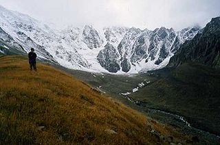
Erebus Glacier is a glacier draining the lower southern slopes of Mount Erebus, Ross Island, Antarctica. It flows west to Erebus Bay where it forms the floating Erebus Glacier Tongue. It was named in association with Mount Erebus by the British National Antarctic Expedition, 1901–04, under Robert Falcon Scott.

Timothy George Haskell is a New Zealand scientist.
