
The Ross Embayment is a large region of Antarctica, comprising the Ross Ice Shelf and the Ross Sea, that lies between East and West Antarctica.
The Ross Embayment is a large region of Antarctica, comprising the Ross Ice Shelf and the Ross Sea, that lies between East and West Antarctica.
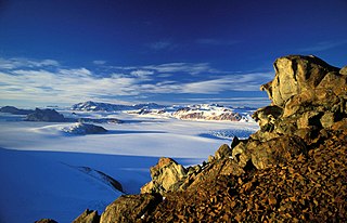
The continent of Antarctica has two major divisions; West Antarctica in mostly western longitudes and East Antarctica in mostly eastern longitudes. East Antarctica is the larger and has a higher average elevation. Separating the two subcontinents is a lower elevation topographic region occupied by the Ross Ice Shelf and the Ross Sea. This region is referred to as the Ross Embayment. The embayment comprises an area of approximately 1,137,000 square kilometres (439,000 sq mi). It includes the Ross Sea (637,000 square kilometres (246,000 sq mi)) [1] and the Ross Ice Shelf (as of 2013, 500,809 square kilometres (193,363 sq mi)). [2] The name is most commonly used in the scientific literature, [3] [4] [5] at times along with the West Antarctic Rift System, which is of larger extent and has geologic meaning. [6] Because the rift system includes the embayment, the latter is considered to lie in West Antarctica.
The informal use of the name 'Ross Embayment' tends to denote a smaller region than the rift system. The embayment extends from Northern Victoria Land and the Transantarctic Mountains on the west (in East Antarctica) to the Edward VII Peninsula, Shirase Coast, and Siple Coast on the east (Marie Byrd Land in West Antarctica), and south to the grounding line of the Ross Ice Shelf. [1]

The low elevation marine characteristic of the Ross Embayment formed since the Jurassic period. [7] Before that time and earlier East and West Antarctica had similar elevations and the Ross Embayment did not exist. [7] [8] [9] The breakup of the eastern sector of Gondwana in Cretaceous time resulted in crustal extension, thinning and subsidence to form the Ross Embayment. [10] The mechanism of crustal stretching and subsidence in the Ross Embayment has been attributed to detachment faulting. [11] Extension between East and West Antarctica totals about 500 kilometers. [12] Half of this occurred prior to sea floor spreading that separated the New Zealand microcontinents (Zealandia) from Antarctica beginning at 85 million years. [13] The remaining extension occurred in the Central Trough, Northern Basin, and Victoria Land Basin in the western Ross Sea before late Miocene time. [12] [14] Subsidence continued as mantle under the Ross Embayment cooled. [12]

The geography of Antarctica is dominated by its south polar location and, thus, by ice. The Antarctic continent, located in the Earth's southern hemisphere, is centered asymmetrically around the South Pole and largely south of the Antarctic Circle. It is washed by the Southern Ocean or, depending on definition, the southern Pacific, Atlantic, and Indian Oceans. It has an area of more than 14.2 million km2. Antarctica is the largest ice desert in the world.

The Ross Sea is a deep bay of the Southern Ocean in Antarctica, between Victoria Land and Marie Byrd Land and within the Ross Embayment, and is the southernmost sea on Earth. It derives its name from the British explorer James Clark Ross who visited this area in 1841. To the west of the sea lies Ross Island and Victoria Land, to the east Roosevelt Island and Edward VII Peninsula in Marie Byrd Land, while the southernmost part is covered by the Ross Ice Shelf, and is about 200 miles (320 km) from the South Pole. Its boundaries and area have been defined by the New Zealand National Institute of Water and Atmospheric Research as having an area of 637,000 square kilometres (246,000 sq mi).

The Weddell Sea is part of the Southern Ocean and contains the Weddell Gyre. Its land boundaries are defined by the bay formed from the coasts of Coats Land and the Antarctic Peninsula. The easternmost point is Cape Norvegia at Princess Martha Coast, Queen Maud Land. To the east of Cape Norvegia is the King Haakon VII Sea. Much of the southern part of the sea is covered by a permanent, massive ice shelf field, the Filchner-Ronne Ice Shelf.

The Antarctic Plate is a tectonic plate containing the continent of Antarctica, the Kerguelen Plateau, and some remote islands in the Southern Ocean and other surrounding oceans. After breakup from Gondwana, the Antarctic plate began moving the continent of Antarctica south to its present isolated location, causing the continent to develop a much colder climate. The Antarctic Plate is bounded almost entirely by extensional mid-ocean ridge systems. The adjoining plates are the Nazca Plate, the South American Plate, the African Plate, the Somali Plate, the Indo-Australian Plate, the Pacific Plate, and, across a transform boundary, the Scotia Plate.

The Amundsen Sea is an arm of the Southern Ocean off Marie Byrd Land in western Antarctica. It lies between Cape Flying Fish to the east and Cape Dart on Siple Island to the west. Cape Flying Fish marks the boundary between the Amundsen Sea and the Bellingshausen Sea. West of Cape Dart there is no named marginal sea of the Southern Ocean between the Amundsen and Ross Seas. The Norwegian expedition of 1928–1929 under Captain Nils Larsen named the body of water for the Norwegian polar explorer Roald Amundsen while exploring this area in February 1929.
The Transantarctic Mountains comprise a mountain range of uplifted rock in Antarctica which extends, with some interruptions, across the continent from Cape Adare in northern Victoria Land to Coats Land. These mountains divide East Antarctica and West Antarctica. They include a number of separately named mountain groups, which are often again subdivided into smaller ranges.

Marie Byrd Land (MBL) is an unclaimed region of Antarctica. With an area of 1,610,000 km2 (620,000 sq mi), it is the largest unclaimed territory on Earth. It was named after the wife of American naval officer Richard E. Byrd, who explored the region in the early 20th century.

West Antarctica, or Lesser Antarctica, one of the two major regions of Antarctica, is the part of that continent that lies within the Western Hemisphere, and includes the Antarctic Peninsula. It is separated from East Antarctica by the Transantarctic Mountains and is covered by the West Antarctic Ice Sheet. It lies between the Ross Sea, and the Weddell Sea. It may be considered a giant peninsula, stretching from the South Pole towards the tip of South America.

The Nordenskjöld Coast is located on the Antarctic Peninsula, more specifically Graham Land, which is the top region of the Peninsula. The Peninsula is a thin, long ice sheet with an Alpine-style mountain chain. The coast consists of 15m tall ice cliffs with ice shelves.

The West Antarctic Rift System is a series of rift valleys between East and West Antarctica. It encompasses the Ross Embayment, the Ross Sea, the area under the Ross Ice Shelf and a part of Marie Byrd Land in West Antarctica, reaching to the base of the Antarctic Peninsula. It has an estimated length of 3,000 km (1,900 mi) and a width of approximately 700 km (430 mi). Its evolution is due to lithospheric thinning of an area of Antarctica that resulted in the demarcation of East and West Antarctica. The scale and evolution of the rift system has been compared to that of the Basin and Range Province of the Western United States.

The geology of Antarctica covers the geological development of the continent through the Archean, Proterozoic and Phanerozoic eons.
The Erebus hotspot is a volcanic hotspot responsible for the high volcanic activity on Ross Island in the western Ross Sea of Antarctica. Its current eruptive zone, Mount Erebus, has erupted continuously since its discovery in 1841. Magmas of the Erebus hotspot are similar to those erupted from hotspots at the active East African Rift in eastern Africa. Mount Bird at the northernmost end of Ross Island and Mount Terror at its eastern end are large basaltic shield volcanoes that have been potassium-argon dated 3.8–4.8 and 0.8–1.8 million years old.

The East Antarctic Shield or Craton is a cratonic rock body that covers 10.2 million square kilometers or roughly 73% of the continent of Antarctica. The shield is almost entirely buried by the East Antarctic Ice Sheet that has an average thickness of 2200 meters but reaches up to 4700 meters in some locations. East Antarctica is separated from West Antarctica by the 100–300 kilometer wide Transantarctic Mountains, which span nearly 3,500 kilometers from the Weddell Sea to the Ross Sea. The East Antarctic Shield is then divided into an extensive central craton that occupies most of the continental interior and various other marginal cratons that are exposed along the coast.
The South China Sea Basin is one of the largest marginal basins in Asia. South China Sea is located to the east of Vietnam, west of Philippines and the Luzon Strait, and north of Borneo. Tectonically, it is surrounded by the Indochina Block on the west, Philippine Sea Plate on the east, Yangtze Block to the north. A subduction boundary exists between the Philippine Sea Plate and the Asian Plate. The formation of the South China Sea Basin was closely related with the collision between the Indian Plate and Eurasian Plates. The collision thickened the continental crust and changed the elevation of the topography from the Himalayan orogenic zone to the South China Sea, especially around the Tibetan Plateau. The location of the South China Sea makes it a product of several tectonic events. All the plates around the South China Sea Basin underwent clockwise rotation, subduction and experienced an extrusion process from the early Cenozoic to the Late Miocene.

The Adare Basin is a geologic structural basin located north-east of Cape Adare of Antarctica, for which its named, and north of the western Ross Sea. The Adare Basin is an extensional rift basin located along a seafloor spreading center that forms the failed arm of the Tertiary spreading ridge separating East and West Antarctica, known as the West Antarctic Rift System and similar in structure to the East Africa Rift System. Centrally located in the Adare Basin is the Adare Trough. The extension of this rift system is recorded in a series of magnetic anomalies which run along the seafloor at the extinct, north–south trending, Adare spreading axis. The Adare spreading system continues unbroken into the Northern Basin underlying the adjacent Ross Sea continental shelf.

The Bransfield Basin is a back-arc rift basin located off the northern tip of the Antarctic Peninsula. The basin lies within a Northeast and Southwest trending strait that separates the peninsula from the nearby South Shetland Islands to the Northwest. The basin extends for more than 500 kilometres from Smith Island to a portion of the Hero Fracture Zone. The basin can be subdivided into three basins: Western, Central, and Eastern. The Western basin is 130 kilometres long by 70 kilometres wide with a depth of 1.3 kilometres, the Central basin is 230 kilometres long by 60 kilometres wide with a depth of 1.9 kilometres, and the Eastern basin is 150 kilometres long by 40 kilometres wide with a depth of over 2.7 kilometres. The three basins are separated by the Deception Island and Bridgeman Island. The moho depth in the region has been seismically interpreted to be roughly 34 kilometres deep.

Christine Siddoway is an American Antarctic researcher, best known for her work on the geology and tectonics of the Ford Ranges in western Marie Byrd Land. Other discoveries relate to preserved records of continental-interior sedimentation during the Sturtian glaciation, Cryogenian Period, in Rodinia, and evidence of a reduced Pliocene extent of the West Antarctic ice sheet, based upon investigation of clasts transported to/deposited in deep water by Ice rafting in the Amundsen Sea.

Patagonia comprises the southernmost region of South America, portions of which lie on either side of the Argentina-Chile border. It has traditionally been described as the region south of the Rio, Colorado, although the physiographic border has more recently been moved southward to the Huincul fault. The region's geologic border to the north is composed of the Rio de la Plata craton and several accreted terranes comprising the La Pampa province. The underlying basement rocks of the Patagonian region can be subdivided into two large massifs: the North Patagonian Massif and the Deseado Massif. These massifs are surrounded by sedimentary basins formed in the Mesozoic that underwent subsequent deformation during the Andean orogeny. Patagonia is known for its vast earthquakes and the damage they cause.

Bruce Peter Luyendyk is an American geophysicist and oceanographer, currently professor emeritus of marine geophysics at the University of California, Santa Barbara. His work spans marine geology of the major ocean basins, the tectonics of southern California, marine hydrocarbon seeps, and the tectonics and paleoclimate of Antarctica. His research includes tectonic rotations of the California Transverse Ranges, participation in the discovery of deep-sea hydrothermal vents, quantitative studies of marine hydrocarbon seeps, and geologic exploration of the Ford Ranges in Marie Byrd Land, Antarctica.

The geology of the Ellsworth Mountains, Antarctica, is a rock record of continuous deposition that occurred from the Cambrian to the Permian periods, with basic igneous volcanism and uplift occurring during the Middle to Late Cambrian epochs, deformation occurring in the Late Permian period or early Mesozoic era, and glacier formation occurring in the Cretaceous period and Cenozoic era. The Ellsworth Mountains are located within West Antarctica at 79°S, 85°W. In general, it is made up of mostly rugged and angular peaks such as the Vinson Massif, the highest mountain in Antarctica.
{{cite journal}}: CS1 maint: multiple names: authors list (link){{cite journal}}: CS1 maint: multiple names: authors list (link){{cite journal}}: CS1 maint: multiple names: authors list (link)