
The Leverett Glacier is about 50 nautical miles (90 km) long and 3 to 4 nautical miles wide, flowing from the Antarctic Plateau to the south end of the Ross Ice Shelf through the Queen Maud Mountains. It is an important part of the South Pole Traverse from McMurdo Station to the Admundson–Scott South Pole Station, providing a route for tractors to climb from the ice shelf through the Transantarctic Mountains to the polar plateau.

The Byrd Glacier is a major glacier in Antarctica, about 136 km (85 mi) long and 24 km (15 mi) wide. It drains an extensive area of the Antarctic plateau, and flows eastward to discharge into the Ross Ice Shelf.
The Amundsen Glacier is a major Antarctic glacier, about 7 to 11 km wide and 150 km (80 nmi) long. It originates on the Antarctic Plateau where it drains the area to the south and west of Nilsen Plateau, then descends through the Queen Maud Mountains to enter the Ross Ice Shelf just west of the MacDonald Nunataks.
The Herbert Range is a range in the Queen Maud Mountains of Antarctica, extending from the edge of the Antarctic Plateau to the Ross Ice Shelf between the Axel Heiberg Glacier and Strom Glacier. Named by the New Zealand Antarctic Place-Names Committee (NZ-APC) for Walter W. Herbert, leader of the Southern Party of the New Zealand GSAE (1961–62) which explored the Axel Heiberg Glacier area.
Lillie Glacier is a large glacier in Antarctica, about 100 nautical miles long and 10 nautical miles wide. It lies between the Bowers Mountains on the west and the Concord Mountains and Anare Mountains on the east, flowing to Ob' Bay on the coast and forming the Lillie Glacier Tongue.
Tucker Glacier is a major valley glacier of Victoria Land, Antarctica, about 90 nautical miles long, flowing southeast between the Admiralty Mountains and the Victory Mountains to the Ross Sea. There is a snow saddle at the glacier's head, just west of Homerun Range, from which the Ebbe Glacier flows northwestward.

The Ford Ranges are a collection of mountain groups and ranges standing east of Sulzberger Ice Shelf and Block Bay in the northwest part of Marie Byrd Land, Antarctica.
Quarles Range is a high and rugged range of the Queen Maud Mountains, extending from the polar plateau between Cooper Glacier and Bowman Glacier and terminating near the edge of Ross Ice Shelf.
Lennox-King Glacier is a large valley glacier, about 40 nautical miles (70 km) long that flows east into the Ross Ice Shelf.

The Scott Glacier is a major glacier, 120 nautical miles long, that drains the East Antarctic Ice Sheet through the Queen Maud Mountains to the Ross Ice Shelf. The Scott Glacier is one of a series of major glaciers flowing across the Transantarctic Mountains, with the Amundsen Glacier to the west and the Leverett and Reedy glaciers to the east.
The Hays Mountains are a large group of mountains and peaks of the Queen Maud Mountains of Antarctica, surmounting the divide between the lower portions of Amundsen Glacier and Scott Glacier and extending from the vicinity of Mount Thorne on the northwest to Mount Dietz on the southeast.

Liv Glacier is a steep valley glacier, 40 nautical miles long, emerging from the Antarctic Plateau just southeast of Barnum Peak and draining north through the Queen Maud Mountains to enter Ross Ice Shelf between Mayer Crags and Duncan Mountains. It was discovered in 1911 by Roald Amundsen, who named it for the daughter of Fridtjof Nansen.
The Land Glacier is a broad, heavily crevassed glacier, about 35 nautical miles long, descending into Land Bay in Marie Byrd Land, Antarctica. It was discovered by the United States Antarctic Service (1939–41) and named for Rear Admiral Emory S. Land, Chairman of the United States Maritime Commission.

An iceport is a more-or-less permanent indentation in the front of an ice shelf, that can serve as a natural ice harbour. Though useful, they are not always reliable, as calving of surrounding ice shelves can render an iceport temporarily unstable and unusable.
Rennick Glacier is broad glacier, nearly 200 nautical miles long, which is one of the largest in Antarctica. It rises on the polar plateau westward of Mesa Range and is 20 to 30 nautical miles wide, narrowing to 10 nautical miles near the coast. It takes its name from Rennick Bay where the glacier reaches the sea.
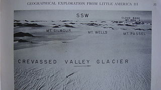
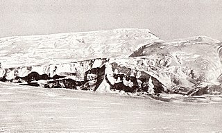
The Denfeld Mountains are a group of scattered mountains between Crevasse Valley Glacier and Arthur Glacier in the Ford Ranges of Marie Byrd Land, Antarctica.

The Dufek Coast is that portion of the coast along the southwest margin of the Ross Ice Shelf between Airdrop Peak on the east side of the Beardmore Glacier and Morris Peak on the east side of Liv Glacier. It was named by the New Zealand Antarctic Place-Names Committee in 1961 after Rear Admiral George J. Dufek, United States Navy, who served under Rear Admiral Richard E. Byrd with the United States Antarctic Service, 1939–41, and as commander of the Eastern Task Force of U.S. Navy Operation Highjump, 1946–47. He was Commander of U.S. Naval Support Force Antarctica, 1954–59, a period in which the following American science stations were established: McMurdo Station, Little America V, Byrd Station, South Pole Station, Wilkes Station, Hallett Station and Ellsworth Station. United States Navy ships, aircraft, and personnel under his command provided broad logistical support to research and survey operations, including aerial photographic missions to virtually all sectors of Antarctica. On October 31, 1956, Dufek in the ski-equipped R4D Skytrain aircraft Que Sera Sera, flew from McMurdo Sound via Beardmore Glacier to make the first airplane landing at the South Pole.
The Duncan Mountains are a group of rugged coastal foothills, about 18 nautical miles long, extending from the mouth of Liv Glacier to the mouth of Strom Glacier at the head of the Ross Ice Shelf in Antarctica.

The Hull Glacier is a glacier, about 35 nautical miles long, flowing northwest between Mount Giles and Mount Gray into Hull Bay, in Marie Byrd Land, Antarctica.

Sarnoff Mountains is a range of mountains, 251 nautical miles long and 4 to 8 nautical miles wide separating the west-flowing Boyd Glacier and Arthur Glacier in the Ford Ranges of Marie Byrd Land, Antarctica.