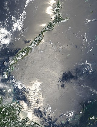
The Sulu Sea is a body of water in the southwestern area of the Philippines,separated from the South China Sea in the northwest by Palawan and from the Celebes Sea in the southeast by the Sulu Archipelago. Borneo is found to the southwest and Visayas to the northeast.
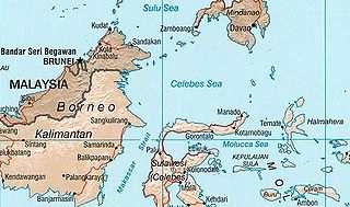
The Celebes Sea or Sulawesi Sea of the western Pacific Ocean is bordered on the north by the Sulu Archipelago and Sulu Sea and Mindanao Island of the Philippines,on the east by the Sangihe Islands chain,on the south by Sulawesi's Minahasa Peninsula,and the west by northern Kalimantan in Indonesia. It extends 420 miles (675 km) north-south by 520 mi (840 km) east-west and has a total surface area of 110,000 square miles (280,000 km2),to a maximum depth of 20,300 feet (6,200 m). South of the Cape Mangkalihat,the sea opens southwest through the Makassar Strait into the Java Sea.
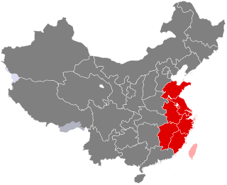
East China is a geographical and a loosely defined cultural region that covers the eastern coastal area of China.
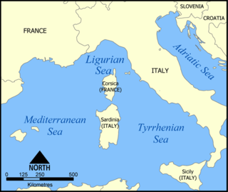
The Ligurian Sea is an arm of the Mediterranean Sea. It lies between the Italian Riviera (Liguria) and the island of Corsica. The sea is thought to have been named after the ancient Ligures people.

Xingcheng,former name Ningyuan (宁远),is a county-level city under the administration of Huludao,in southwest Liaoning province,China,with a population of approximately 140,000 urban inhabitants,and is located on the Liaodong Bay,i.e. the northern coast of the Bohai Sea. The area is steeped in history,and contains one of the best preserved Ming Dynasty towns in China,as well as functioning as a laidback summer resort.
This is a list of points in the Philippines that are farther north,south,east,or west than any other location in the country. Also included are extreme points in elevation,extreme distances,and other points of geographic interest.

The Miyako Islands are a group of islands in Okinawa Prefecture,Japan,belonging to the Ryukyu Islands. They are situated between Okinawa Island and the Yaeyama Islands.

Tongli,alternately Tong-Li is a town in Wujiang district,on the outskirts of Suzhou,Jiangsu province. It is known for a system of canals,it has been given the nickname "Venice of the East". The place retains many of the features of an ancient Wu region town.
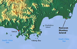
Nanwan Monkey Island is a state-protected nature reserve for macaque monkeys in Lingshui county on the south coast of Hainan,the southernmost province of China. While termed an island,the reserve is actually on the Nanwan peninsula bordering the Xincun harbour on the east and south. It is accessible by China's longest over-water cable car from Xincun,spanning 2,138 metres (7,014 ft).

Jiadong Township is a rural township in Pingtung County,Taiwan.

Taman Wahyu is a residential area in Kampung Batu,Kuala Lumpur,Malaysia. The main inhabitants are Chinese. A Chinese primary school is located about 1.5 kilometers from Taman Wahyu. There are also several coffee shops and a Chinese traditional herb store.

Ōshima (大島) was a steam gunboat,serving in the early Imperial Japanese Navy. She was named after the island of Ōshima off Shizuoka prefecture.
Bon Docteur Nunatak,also known as Good Doctor Nunatak,is a small coastal nunatak,28 metres (92 ft) high,standing at the west side of the Astrolabe Glacier Tongue,400 m (1,300 ft) south of Rostand Island in the Geologie Archipelago of Antarctica. It was photographed from the air by U.S. Navy Operation Highjump,1946–47,charted by the French Antarctic Expedition,1952–53,and named for Dr Jean Cendron,the "good doctor",medical officer and biologist with the French Antarctic Expedition,1951–52.
Rostand Island is a rocky island 400 m long and 200 m south-east of Petrel Island in the Geologie Archipelago of Antarctica. It was charted in 1951 by the French Antarctic Expedition and named by them for Jean Rostand,noted French biologist.

Kakralaid is an island belonging to the country of Estonia.
Seasaar is an island belonging to Estonia.

Yoda Ela or Jaya Ganga,an 87 km (54 mi) long single banking water canal carrying excess water to Tissa Wewa reservoir from Kala Wewa reservoir in Anuradhapura. The Yodha Ela is known for achieving a rather low gradient for its time. The gradient is about 10 centimetres per kilometre or 6 inches per mile.


