This article needs additional citations for verification .(February 2018) |
An impact crater lake is a lake inside a depression caused by the impact of a meteor. It is also known as an annular lake in cases where the water body is shaped like a ring, as many impact crater lakes are.
One of the largest impact crater lakes is Lake Manicouagan in Canada; the crater is a multiple-ring structure about 100 km (60 mi) across, with its 70 km (40 mi) diameter inner ring its most prominent feature; it contains a 70 km (40 mi) diameter annular lake, surrounding an inner island plateau, René-Levasseur Island. It is Earth's sixth-largest confirmed impact crater according to rim-to-rim diameter. [1]
An impact crater is a circular depression in the surface of a solid astronomical object formed by the hypervelocity impact of a smaller object. In contrast to volcanic craters, which result from explosion or internal collapse, impact craters typically have raised rims and floors that are lower in elevation than the surrounding terrain. Lunar impact craters range from microscopic craters on lunar rocks returned by the Apollo program and small, simple, bowl-shaped depressions in the lunar regolith to large, complex, multi-ringed impact basins. Meteor Crater is a well-known example of a small impact crater on Earth.
The Chicxulub crater is an impact crater buried underneath the Yucatán Peninsula in Mexico. Its center is offshore, but the crater is named after the onshore community of Chicxulub Pueblo. It was formed slightly over 66 million years ago when a large asteroid, about ten kilometers in diameter, struck Earth. The crater is estimated to be 180 kilometers in diameter and 20 kilometers in depth. It is the second largest confirmed impact structure on Earth, and the only one whose peak ring is intact and directly accessible for scientific research.
Manicouagan Reservoir is an annular lake in central Quebec, Canada, covering an area of 1,942 km2 (750 sq mi). The lake island in its centre is known as René-Levasseur Island, and its highest point is Mount Babel. The structure was created 214 (±1) million years ago, in the Late Triassic, by the impact of a meteorite 5 km (3 mi) in diameter. The lake and island are clearly seen from space and are sometimes called the "eye of Quebec". The lake has a volume of 137.9 km3 (33.1 cu mi).
The Araguainha crater or Araguainha dome is an impact crater on the border of Mato Grosso and Goiás states, Brazil, between the villages of Araguainha and Ponte Branca. With a diameter of 40 kilometres (25 mi), it is the largest known impact crater in South America.
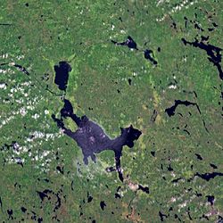
Keurusselkä is a lake in Central Finland between the towns of Keuruu to the north and Mänttä to the south. It covers an area of 117.3 km2 (45.3 sq mi). Its average depth is 6.4 m (21 ft) with a maximum depth of 40 m (130 ft). The surface lies at 105.4 m (346 ft) above sea level. The lake is 27 km (17 mi) long and is a part of the Kokemäenjoki water system. Keurusselkä gained international publicity in 2004 when a pair of amateur geologists discovered an ancient impact crater on the western shore of the lake.
Mien is a lake in southern Sweden, 12 km (7.5 mi) southwest of the town of Tingsryd. The lake is formed within a meteorite crater.
Mistastin crater is a meteorite crater in Labrador, Canada which contains the roughly circular Mistastin Lake. The lake is approximately 16 km (9.9 mi) in diameter, while the estimated diameter of the original crater is 28 km (17 mi). The age of the crater is calculated to be 36.6 ± 2 million years (Eocene).
Puchezh-Katunki is a meteor crater located in the Nizhny Novgorod Oblast of the Volga Federal District, Russia. It is 80 km (50 mi) in diameter. Argon–argon dating has constrained the age of formation to be 195.9 ± 1.0 million years old, placing it within the Sinemurian stage of the Early Jurassic. The crater is not exposed to the surface, but appears as variation in the vegetation. The Earth Impact Database lists a rim-to-rim diameter of 40 kilometres (25 mi).
Shoemaker is an impact structure, the deeply eroded remnant of a former impact crater, situated in arid central Western Australia, about 100 km (62 mi) north-northeast of Wiluna. It is named in honour of planetary geologist Eugene Shoemaker.
The Vredefort impact structure is one of the largest verified impact structures on Earth. The crater, which has since been eroded away, has been estimated at 170–300 kilometres (110–190 mi) across when it was formed. The remaining structure, comprising the deformed underlying bedrock, is located in present-day Free State province of South Africa. It is named after the town of Vredefort, which is near its centre. The structure's central uplift is known as the Vredefort Dome. The impact structure was formed during the Paleoproterozoic Era, 2,023 million years ago. It is the second-oldest known impact structure on Earth, after Yarrabubba.
Cleopatra, initially called Cleopatra Patera, is an impact crater on Venus, in Maxwell Montes.
Mead is an impact crater on Venus named in honor of the cultural anthropologist Margaret Mead.
The Lac Wiyâshâkimî, also called the Clearwater Lakes in English and Allait Qasigialingat by the Inuit, are a pair of annular lakes and possible impact craters on the Canadian Shield in Quebec, Canada, near Hudson Bay.
The Beethoven quadrangle is located in the equatorial region of Mercury, in the center of the area imaged by Mariner 10. Most pictures of the quadrangle were obtained at high sun angles as the Mariner 10 spacecraft receded from the planet. Geologic map units are described and classified on the basis of morphology, texture, and albedo, and they are assigned relative ages based on stratigraphic relations and on visual comparisons of the density of superposed craters. Crater ages are established by relative freshness of appearance, as indicated by topographic sharpness of their rim crests and degree of preservation of interior and exterior features such as crater floors, walls, and ejecta aprons. Generally, topography appears highly subdued because of the sun angle, and boundaries between map units are not clearly defined.
Ramgarh crater, also known as Ramgarh structure, Ramgarh Dome and Ramgarh astrobleme, is a meteor impact crater of 3.5 kilometres (2.2 mi) diameter in Kota plateau of Vindhya range located adjacent to Ramgarh village in Mangrol tehsil of Baran district in Rajasthan state of India. When formally accepted as the third crater in India, its diameter size would be between the two already confirmed craters in India - Dhala in Madhya Pradesh with 14 km diameter and Lonar in Buldhana district of Maharashtra with 1.8 km diameter.
Lofn is a large relatively young impact crater on Jupiter's Galilean satellite Callisto. It was identified in 1997 and named after the goddess of marriage in Norse mythology. Located near the south pole of this moon, Lofn is classified as a flat floored or anomalous dome impact crater. It is superimposed on Adlinda multilayer structure obscuring about 30 percent of it. Another multi-ring structure—Heimdall is found to the south-west of Lofn.
Rembrandt is a large impact crater on Mercury. With a diameter of 716 km it is the second-largest impact basin on the planet, after Caloris, and is one of the larger craters in the Solar System. It was discovered by MESSENGER during its second flyby of Mercury on October 6, 2008. The crater is 3.9 billion years old, and was created during the period of Late Heavy Bombardment. The density and size distribution of impact craters along Rembrandt's rim indicate that it is one of the youngest impact basins on Mercury.
Complex craters are a type of large impact crater morphology.
The Charity Shoal crater is a 1.2–1.4 kilometers (0.75–0.87 mi) in diameter circular feature that lies submerged beneath the northeast end of Lake Ontario about 12 kilometers (7.5 mi) southwest of Wolfe Island, and 25 kilometers (16 mi) south of Kingston, Ontario at about latitude 44° 02′ N and longitude 76° 29′ W. It is hypothesized to be a Middle Ordovician impact crater.
Vai Lahi is the central crater lake of the Tongan island of Niuafoʻou. The island is the most northerly island of Tonga, is the most northerly island in the kingdom of Tonga, and is located some 570 km north of the kingdom's main island, Tongatapu. Niuafoʻou is annular in shape, the rim of an active volcano. The island ring encloses two large lakes, Vai Lahi and the much smaller Vai Siʻi, plus some eight much smaller ponds.