
Laguna de Términos is the largest tidal lagoon by volume located entirely on the Gulf of Mexico, as well as one of the most biodiverse. Exchanging water with several rivers and lagoons, the Laguna is part of the most important hydrographic river basin in Mexico. It is important commercially, as well as ecologically by serving as a refuge for extensive flora and fauna; its mangroves play an important role as a refuge for migratory birds.

The Cordillera Oriental is the widest of the three branches of the Colombian Andes. The range extends from south to north, dividing from the Colombian Massif in Huila Department to Norte de Santander Department where it splits into the Serranía del Perijá and the Cordillera de Mérida in Venezuelan Andes. The highest peak is Ritacuba Blanco at 5,410 m (17,750 ft) in the Sierra Nevada del Cocuy.
Calipuy National Sanctuary is a Peruvian protected area created on January 8, 1981. The 4,500-hectare (11,000-acre) sanctuary, adjacent to the larger Calipuy National Reserve, is located in the Santiago de Chuco Province of the La Libertad region in northwestern Peru.

The Cocora Valley is a valley in the Quindío Department of Colombia. It is located in the Central Cordillera of the Andean mountains. "Cocora" was the name of a Quimbayan princess, daughter of the local chief Acaime, and means "star of water".

Amacayacu National Natural Park is a national park located along the Amazon River in the Amazonas Department in the south of Colombia. The word "Amacayacu" means "River of the Hamocs" in the indigenous language Quechua. The Ticuna people currently inhabit a part of the park.
Cocha Cashu Biological Station is a tropical biological research station located at 11° 54'S and 71° 22'W in Manú National Park, Peru. It was established in 1969-70, predating the founding of its containing national park. Though only 10 km2 in area, the site has provided valuable research. The station is situated on the shore of an oxbow lake, from which it takes its name. "Qucha" is the Quechua word for lake. "Cashu" is derived from the English word "cashew" and refers to the shape of the lake.

The contribution of travel and tourism to GDP was US$5,880.3bn in 2016. Tourism generated 556,135 jobs in 2016. Foreign tourist visits were predicted to have risen from 0.6 million in 2007 to 4 million in 2017. Responsible tourism became a peremptory need for Colombia because it minimizes negative social, economic and environmental impacts and makes positive contributions to the conservation of natural and cultural heritage.

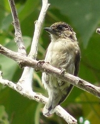
Los Flamencos Sanctuary has been a designated wildlife sanctuary since 1977. It is located in the Guajira Peninsula of Colombia's Caribbean Region. Its main attraction is the American flamingoes, and their nests that can reach 60 cm (2.0 ft) high.
The Cauca Valley dry forests is a tropical dry broadleaf forest ecoregion in Colombia.

The Chilean Matorral (NT1201) is a terrestrial ecoregion of central Chile, located on the west coast of South America. It is in the Mediterranean forests, woodlands, and scrub biome, part of the Neotropical realm.

The Eduardo Avaroa Andean Fauna National Reserve is located in Sur Lípez Province. Situated in the far southwestern region of Bolivia, it is the country's most visited protected area. It is considered the most important protected area in terms of tourist influx in the Potosí Department.
Tourism in Bolivia is one of the key economic sectors of the country. According to data from the National Institute of Statistics of Bolivia (INE), there were over 1.24 million tourists that visited the country in 2020, making Bolivia the ninth most visited country in South America.

The Salamanca Island Road Park is a national park located in the Caribbean Region of Colombia, on the western outskirts of the city of Ciénaga in the Magdalena Department. The flora and fauna is in abundance because of the confluence of sweet water flowing from the Magdalena River and saline water of the Caribbean Sea. It was created in 1964 to protect the abundant bird life and coastal mangroves.
The "El mono Hernández" Cork Forest Flora and Fauna Sanctuary is a natural monument located in the Sucre and Bolívar Departments on the coast of the Caribbean Region of Colombia.
The Tamá National Natural Park is a national park located in the Tamá Massif of the Andean Region of Colombia, between the municipalities Toledo and Herrán, in the department of Norte de Santander, in the northeastern part of the Eastern Ranges of the Colombian Andes. One of the main attractions of the park is a 820-metre-high (2,690 ft) waterfall, one of the world's highest.

The Southern Andean Yungas is a tropical and subtropical moist broadleaf forest ecoregion in the Yungas of southwestern Bolivia and northwestern Argentina.

The Ocetá Páramo is a páramo, which means an ecosystem above the continuous forest line yet below the permanent snowline. This particular páramo is located at altitudes between 2,950 metres (9,680 ft) and 3,950 metres (12,960 ft) in the Eastern Ranges of the Colombian Andes. It covers parts of the municipalities Monguí, Mongua and Tópaga, belonging to the Sugamuxi Province, Boyacá. The Ocetá Páramo is known for its collection of small shrubs called frailejones, as well as other Andean flora and fauna. Hiking tours from Monguí or Mongua to the páramo take a full day.
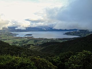
La Cocha Lagoon is a 39,000-hectare (96,000-acre) volcanic crater lake located within the Pasto Municipality in Nariño, Colombia.
