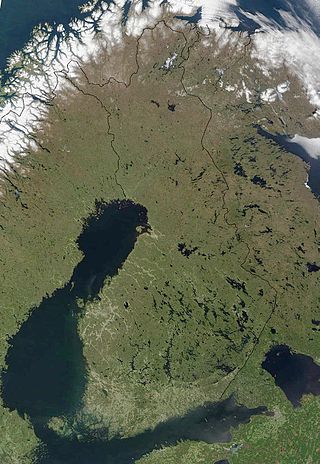
The geography of Finland is characterized by its northern position, its ubiquitous landscapes of intermingled boreal forests and lakes, and its low population density. Finland can be divided into three areas: archipelagoes and coastal lowlands, a slightly higher central lake plateau and uplands to north and northeast. Bordering the Baltic Sea, Gulf of Bothnia, and Gulf of Finland, as well as Sweden to the west, Norway to the north, and Russia to the east, Finland is the northernmost country in the European Union. Most of the population and agricultural resources are concentrated in the south. Northern and eastern Finland are sparsely populated containing vast wilderness areas. Taiga forest is the dominant vegetation type.

Lake Ladoga is a freshwater lake located in the Republic of Karelia and Leningrad Oblast in northwestern Russia, in the vicinity of Saint Petersburg.
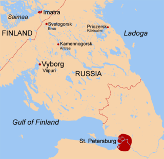
The Karelian Isthmus is the approximately 45–110-kilometre-wide (30–70 mi) stretch of land situated between the Gulf of Finland and Lake Ladoga in northwestern Russia, to the north of the River Neva. Its northwestern boundary is a line from the Bay of Vyborg to the westernmost point of Lake Ladoga, Pekonlahti. If the Karelian Isthmus is defined as the entire territory of present-day Saint Petersburg and Leningrad Oblast to the north of the Neva and also a tiny part of the Republic of Karelia, the area of the isthmus is about 15,000 km2 (5,800 sq mi).

Näsinneula is an observation tower in Tampere, Finland, overseeing Lake Näsijärvi. It was built in 1970–1971 and was designed by Pekka Ilveskoski. It is the tallest free-standing structure in Finland and at present the tallest observation tower in the Nordic countries at a height of 168 metres (551 ft). The tower opened in 1971 and is located in the Särkänniemi amusement park. There is a revolving restaurant in the tower 124 metres (407 ft) above the ground; one revolution takes 45 minutes. The design of Näsinneula was inspired by the Space Needle in Seattle. The idea of a revolving restaurant was taken from the Puijo Tower, which is located in Kuopio, the city of North Savonia.

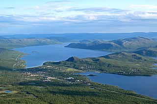
A fell is a high and barren landscape feature, such as a mountain or moor-covered hill. The term is most often employed in Fennoscandia, Iceland, the Isle of Man, parts of northern England, and Scotland.

Karelia is an area in Northern Europe of historical significance for Russia, Finland, and Sweden. It is currently divided between northwestern Russia and Finland.

Keurusselkä is a lake in Central Finland between the towns of Keuruu to the north and Mänttä to the south. It covers an area of 117.3 km2 (45.3 sq mi). Its average depth is 6.4 m (21 ft) with a maximum depth of 40 m (130 ft). The surface lies at 105.4 m (346 ft) above sea level. The lake is 27 km (17 mi) long and is a part of the Kokemäenjoki water system. Keurusselkä gained international publicity in 2004 when a pair of amateur geologists discovered an ancient impact structure on the western shore of the lake.

Päijät-Häme is a region in Southern Finland south of the lake Päijänne. It borders the regions of Uusimaa, Kanta-Häme, Pirkanmaa, Central Finland, South Savo and Kymenlaakso. The biggest city in the region is Lahti.

Jukkasjärvi is a locality situated in Kiruna Municipality, Norrbotten County, Sweden with 548 inhabitants in 2010. It is situated at 321 meters elevation.
Kilpisjärvi is a village in the municipality of Enontekiö, Lapland, Finland. It is located in Finland's northwestern "arm" near the northwesternmost point of Finland.

The Kymi is a river in Finland. It begins at Lake Päijänne, flows through the provinces of Päijänne Tavastia, Uusimaa and Kymenlaakso, and discharges into the Gulf of Finland. The river passes the towns of Heinola and Kouvola. The town of Kotka is located on the river delta. The length of the river is 204 kilometres (127 mi), but its drainage basin of 37,107 square kilometres (14,327 sq mi) extends to almost 600 kilometres (370 mi) inside the Tavastia, Central Finland, Savonia and Ostrobothnia. The furthest source of the river is Lake Pielavesi, its furthest point being some 570 kilometres (350 mi) from the sea measured by flow route. The name of the river, itself, kymi, means "large river", in Old Finnish.
The Kuyto are three lakes in the Republic of Karelia, in the northwestern part of Russia. The Kuyto lakes are connected by natural canals, and are used for timber rafting.

The Näätämöjoki (Finnish), Neidenelva (Norwegian), or Njávdámjohka (Northern Sami) is a river in Finland's Lapland, north of Lake Inari. It flows from Lake Iijärvi in Inari Municipality through Norway's Sør-Varanger Municipality and empties into the Neidenfjorden, an arm off the main Varangerfjorden.

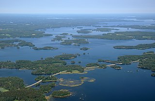
A lake island is any landmass within a lake. It is a type of inland island. Lake islands may form a lake archipelago.

Kilpisjärvi is a medium-sized lake located at the north-western tip of Finland and northernmost Sweden. Treriksröset, the point where the borders of Finland, Sweden and Norway join is located some 2.5 kilometres (1.6 mi) northwest from the lake.

Lake Yurkhyamyayarvi is a freshwater lake in Murmansk Oblast, Russia. It has an elevation of 249 meters (817 ft). The river Vuosnayoki flows from the lake.
Vuokkijärvi is a medium-sized lake in the Oulujoki main catchment area. It is located in the region of Kainuu, eastern Finland. The surface level of the lake is strongly regulated due to power production. Elevation can vary between 183.72 and 189.72 meters.
Kostonjärvi is a medium-sized lake in the Iijoki main catchment area. It is located in Taivalkoski municipality, in the Northern Ostrobothnia region in Finland. The surface elevation on the lake varies almost 5 meter due to the power production.
Längelmävesi is a lake in southwestern Finland. The lake is located mostly in the Pirkanmaa region at an elevation of 84.2 metres (276 ft). Längelmävesi is within the municipalities of Jämsä, Kangasala, Kuhmalahti, and Orivesi.
Savivesi is a medium-sized lake in the Vuoksi main catchment area. It is located in Leppävirta municipality, in the Northern Savonia region, in Finland. Savivesi's elevation is almost the same as the lake Unnukka's elevation, and it is possible to see them as one lake.

