
Otsego County is a county in the U.S. state of New York. As of the 2010 census, the population was 62,259. The county seat is Cooperstown. The name Otsego is from a Mohawk or Oneida word meaning "place of the rock."
Otsego County is a county located in the U.S. state of Michigan. As of the 2020 Census, the population was 25,091. The county seat is Gaylord. The county was founded in 1840 and organized in 1875.
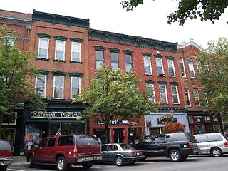
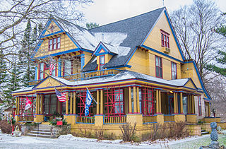
Cooperstown is a village in and county seat of Otsego County, New York, United States. Most of the village lies within the town of Otsego, but some of the eastern part is in the town of Middlefield. Located at the foot of Otsego Lake in the Central New York Region, Cooperstown is approximately 60 miles west of Albany, 67 mi (108 km) southeast of Syracuse and 145 mi (233 km) northwest of New York City. The population of the village was 1,852 as of the 2010 census.

Otsego is a town in the north-central part of Otsego County, New York, United States. The population was 3,900 at the 2010 census. The town is named after Lake Otsego, which forms part of the town's eastern border.

Springfield is a town in Otsego County, New York, United States. The population was 1,358 at the 2010 census.

Otsego Lake is a 4,046-acre (16.37 km2) lake located in Otsego County in the U.S. state of New York. It is the source of the Susquehanna River and largest lake in Otsego County. The Village of Cooperstown is located at the lake's southern end. Glimmerglass State Park is located on the lake's northeastern shore, and includes Hyde Hall, a large mansion constructed in 1817, that overlooks the lake. The Glimmerglass Opera, opened in June 1987, is located on the western shore.

Canadarago Lake is a 1,917-acre (7.76 km2) lake located in Otsego County, New York and is the source of Oaks Creek. The Village of Richfield Springs is located at the lake's northern end. It is the second largest lake in Otsego County, lying to the west of and parallel to the larger Otsego Lake. The lake's name is also spelled "Candajarago Lake" or "Caniadaraga Lake".
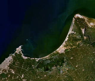
The Abū Qīr Bay is a spacious bay on the Mediterranean Sea near Alexandria in Egypt, lying between the Rosetta mouth of the Nile and the town of Abu Qir. The ancient cities of Canopus, Heracleion and Menouthis lie submerged beneath the waters of the bay. In 1798 it was the site of the Battle of the Nile, a naval battle fought between the British Royal Navy and the navy of the French First Republic. The bay contains a natural gas field, discovered in the 1970s.

Otsego Lake State Park is a public recreation area covering 62 acres (25 ha) on the southeast shore of Otsego Lake in Otsego Lake Township, Otsego County, Michigan.

Otsego Township is one of twelve townships in Steuben County, Indiana, United States. As of the 2010 census, its population was 2,575 and it contained 1,839 housing units.
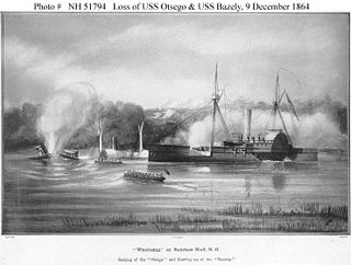
USS Otsego (1863) was a steamer acquired by the Union Navy during the American Civil War. She was used by the Navy to patrol navigable waterways of the Confederacy to prevent the South from trading with other countries.

Otego Creek is a 32.7-mile-long (52.6 km) tributary of the Susquehanna River in Otsego County, New York. Otego Creek rises in the Town of Otsego and flows south through the Towns of Hartwick and Laurens, before joining the Susquehanna River southwest of the City of Oneonta.
Sunken Island or Sunken island may refer to:

Oaks Creek is a river that drains Canadarago Lake, which is situated in the north central region of Otsego County, New York. The creek begins by the Hamlet of Schuyler Lake and flows southeast approximately 9.32 miles (15.00 km), dropping only 105 feet (32 m) in elevation, before converging with the Susquehanna River south of the Village of Cooperstown, by the Hamlet of Index. From the source to Oaksville the creek flows along Panther Mountain. Fly Creek is a main tributary, that converges with Oaks Creek south of the Hamlet of Fly Creek.

Loon Island is a sunken island on Canadarago Lake in Otsego County, New York, United States, which sank in the early 19th century. Smaller than the remaining Deowongo Island on the lake, the "sunken island" was less than an acre in size. Its southern shore was marshy, but the northern end of the island had trees and vegetation.

Shadow Brook, also known as East Springfield Brook, is a river in northern Otsego County in the U.S. State of New York. It begins north-northeast of the Hamlet of East Springfield, and flows into Otsego Lake south-southeast of the Hamlet of Springfield Center, near Glimmerglass State Park. It is the largest watershed in the Otsego Lake basin.

The Canajoharie Creek is a river that flows into the Mohawk River in the Village of Canajoharie in the U.S. State of New York. The name "Canajoharie" is a Mohawk language term meaning "the pot that washes itself", referring to the "Canajoharie Boiling Pot", a 20-foot (6.1 m) wide and 10-foot (3.0 m) deep pothole in the Canajoharie Creek, just south of the village of Canajoharie. Bowmans Creek is one main tributary that enters the creek east of the Hamlet of Sprout Brook. The other main tributary is Brimstone Creek which enters the creek north-northwest of the Village of Ames.

Red House Hill is a mountain in the Central New York Region of New York. It is located south-southwest of the Hamlet of Springfield Center, New York, west of Hutter Point and Six Mile Point of Otsego Lake, and southeast of Rum Hill. Mohican Brook flows eastward along the southern edge of the hill.

Willow Creek is a river in Otsego County, New York. It converges with Cherry Valley Creek north of Middlefield.


