Related Research Articles

Tanzania comprises many lakes, national parks, and Africa's highest point, Mount Kilimanjaro. Northeast Tanzania is mountainous, while the central area is part of a large plateau covered in grasslands. The country also contains the southern portion of Lake Victoria on its northern border with Uganda and Kenya.

The Feather River is the principal tributary of the Sacramento River, in the Sacramento Valley of Northern California. The river's main stem is about 73 miles (117 km) long. Its length to its most distant headwater tributary is just over 210 miles (340 km). The main stem Feather River begins in Lake Oroville, where its four long tributary forks join—the South Fork, Middle Fork, North Fork, and West Branch Feather Rivers. These and other tributaries drain part of the northern Sierra Nevada, and the extreme southern Cascades, as well as a small portion of the Sacramento Valley. The total drainage basin is about 6,200 square miles (16,000 km2), with approximately 3,604 square miles (9,330 km2) above Lake Oroville.

Ibargoiti is a town and municipality located in the province and autonomous community of Navarre, northern Spain.
Mkomazi National Park is located in northeastern Tanzania on the Kenyan border, in Same District of Kilimanjaro Region and Lushoto District, with a slither of the park in Mkinga District both of Tanga Region. It was established as a game reserve in 1951 and upgraded to a national park in 2006.
Harkers Canyon is located 8.5 km (5.3 mi) southeast of the town of Tooele, in Tooele County, Utah, USA. Located high in the Oquirrh Mountains, the canyon is oriented north-south, and drains into Middle Canyon at its northern end. Harkers Canyon is about 2.2 km (1.4 mi) long. The top of the canyon at its southern end is at approximately 2900 m (9500 ft) elevation. The mouth of Harkers Canyon is at 1975 m (6480 ft) elevation. Harkers Canyon is in the Rush Valley watershed.
Sankoo is a town in a valley within the Kargil district of the Union Territory of Ladakh, India. This township is located approximately 42 kilometers south of Kargil city. The valley is shaped like a bowl and is fed by several large tributary streams of the Suru River, as well as the Nakpochu river.
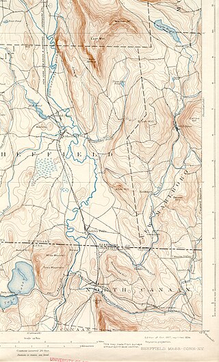
The Konkapot River is a 22.1-mile-long (35.6 km) river in southwestern Massachusetts and northern Connecticut. It is a tributary of the Housatonic River, not to be confused with the smaller Konkapot Brook in Stockbridge.
Umba may refer to
The Umba sapphire is a unique type of sapphire discovered in 1962 in the Gerevi Hills, north of the Umba River in the Umba Valley of Mkinga District of Tanga Region in Tanzania. Umba sapphires exhibit coloration not common to sapphires found in other parts of the world, and are recovered from the alluvial deposits of the Umba River.

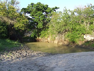
The Umba River is located in northeastern Tanzania in Lushoto and Mkinga Districts of Tanga Region. It rises in Schageiuforest (Shagayu) in the West Usambara Mountains of Lushoto at 2,000 m altitude and flows on the north side of the mountain range to the east. At Lelwa it empties the Mbalamu River, which comes from the extreme north of the Usambara Mountains, and the Mglumi River into the Umba. Just before the Umba flows into the Indian Ocean, it crosses the border to Kenya. The mouth itself marks the most eastern point on the border between Tanzania and Kenya, which was largely made in a straight line to the northwest towards Lake Victoria in the 19th Century. On the upper reaches of the river in the mid-1960s rich deposits of precious stones, including sapphires and spessartine, were discovered. Also on the river is the Umba River Game Reserve, a wildlife reserve that includes along with the Mkomazi Game Reserve, about 2,600 km².
Malaia garnet or Malaya garnet is a gemological varietal name for light to dark slightly pinkish orange, reddish orange, or yellowish orange garnet, that are of a mixture within the pyralspite series pyrope, almandine, and spessartine with a little calcium. The name Malaia is translated from Swahili to mean, prostitute. It is found in east Africa, in the Umba Valley bordering Tanzania and Kenya.
The Ulanga River, also known as the Kilombero River, rises in the highlands of the southwest of Morogoro Region, Tanzania, on the eastern slope of the East African Rift. The river flows northeast along the northeastern border of the Lindi Region before it flows into the Rufiji River. The Rufiji eventually flows into the Indian Ocean on the southern coast of the Pwani Region.

Mkinga District, officially the, Mkinga District Council is one of eleven administrative districts of Tanga Region in Tanzania. It was created from Muheza District in 2007. The District covers an area of 2,712 km2 (1,047 sq mi). The district is comparable in size to the land area of Samoa. The administrative capital of the district is Parungu Kasera. The district is bordered by Tanga District to the south east and Muheza District to the south west. On the east the district is bordered by the Indian Ocean. On the west is Korogwe District and Lushoto District. The latter's northern boundary is a slither of Mkomazi National Park. On the north the district borders Kenya. The highest point in the district is Mhinduro Peak at 913m. The district is home to the Umba Game Controlled Area, the Umba Valley; the world's only source of Umba saffires. According to the 2012 Tanzania National Census, the population of Mkinga District was 118,065.
Marion Township is an inactive township in Monroe County, in the U.S. state of Missouri.
Chouteau Township is an inactive township in Clay County, in the U.S. state of Missouri.
Center Valley is an unincorporated community in Clay Township, Morgan County, in the U.S. state of Indiana.
The Degere are a Mijikenda-speaking group of former hunter-gatherers of Kenya and Tanzania, now settled along the Ramisi, Mwena and Umba rivers, with a few along the coast. They may number no more than a few hundred to at most a few thousand. They are believed to be related to, possibly descended from, the Oromo-speaking Waata. They are variously reported to speak Duruma, Digo, a similar Mijikenda dialect of their own, or to speak Mijikenda with grammatical errors much as the Waata do when they speak Mijikenda.

Abner Santiago Umba López is a Colombian cyclist, who currently rides for UCI Continental team GW Shimano–Sidermec.
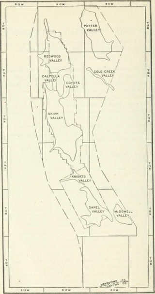
The Ukiah area is an area of 303 square miles (78,000 ha) in southeastern Mendocino County, California that encompasses the arable valleys of the Russian River drainage system and the adjacent parts of the Mendocino Range Mountains of the Pacific Coast Range.
References
4°40′50″N39°12′48″E / 4.6806°N 39.2133°E
| | This Tanzania location article is a stub. You can help Wikipedia by expanding it. |