Lushoto District, Tanga

Last updated
Lushoto
Wilaya ya Lushoto (Swahili)
Wilaya ya Lushoto, Mkoa wa Tanga
Lushoto (2012).JPG
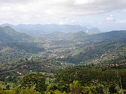
Aerial view of Lushoto
Lushoto District in Tanga 2022.svg
Location within Tanga.
CountryFlag of Tanzania.svg  Tanzania
ZoneNorthern
Region Tanga
Seatmember of parliament
Government
  District CommissionerMajidi mwanga (shabani omari shekilindi)
Area
  Total3,297 km2 (1,273 sq mi)
Population
 (2022)
  Total350,958
  Density110/km2 (280/sq mi)
Time zone UTC+3 (EAT)
Postcode
217xx
Area code 027
Website District website

Lushoto is one of the eleven districts of Tanga Region in Tanzania. It is bordered to the northeast by Kenya, to the east by the Muheza District, to the northwest by the Kilimanjaro Region, west by Korogwe District and to the south by the Bumbuli District. The district's capital and largest town is Lushoto.

Contents

History

It was formerly known as Wilhelmstal (William's Valley) and was named after Emperor Wilhelm II.

During the German colonial period from the 1890s to 1918 the area was popular with settlers, hence the German place name of Wilhelmstal. Large farms and plantations were created, and the district was valued for its pleasant mountain climate. Numerous church missions were, and remain, active.

Between 1893 and 1911 the German Ostafrikanische Eisenbahngesellschaft (East African Railway Company) constructed an important railway line starting at Tanga on the coast and passing along the Usambara Mountains with a station at Mombo, about 20 kilometers (12 mi) from Wilhelmstal, to "New" Moshi at Kilimanjaro. The initial plan of the Usambarabahn was to connect the port of Tanga with Lake Victoria by passing south of the Usambara Mountains. This was in direct competition with parallel British efforts in colonial Kenya. From 4 June 1912 to 12 May 1913 the line was renamed Nordbahn (Northern Railway).

According to the 2002 Tanzania National Census, the population of the Lushoto District was 419,970. [1] By 2012, the population had increased to 492,441. [2] In 2016, Lushoto district was separated from Bumbuli District there to population of Lushot as of 2012 was 332,436. [3] In 2022, the population was 350,958. [4]

Administrative subdivisions

Wards

As of 2012, Lushoto District is administratively divided into 28 wards: [2] [5]

  1. Lushoto
  2. Gare
  3. Kwai
  4. Ubiri
  5. Mtae
  6. Sunga
  7. Rangwi
  8. Mnazi
  9. Lunguza
  10. Mbaramo
  11. Mng'aro
  12. Mlalo
  13. Mwangoi
  14. Shume
  15. Malindi
  16. Hemtoye
  17. Malibwi
  18. Mlola
  19. Makanya
  20. Ngwelo
  21. Kilole
  22. Kwekanga
  23. Lukozi
  24. Manolo
  25. Dule M
  26. Kwemshasha
  27. Ngulwi
  28. Kwemashai

Related Research Articles

Transport in Tanzania includes road, rail, air and maritime networks. The road network is 86,472 kilometres (53,731 mi) long, of which 12,786 kilometres (7,945 mi) is classified as trunk road and 21,105 kilometres (13,114 mi) as regional road. The rail network consists of 3,682 kilometres (2,288 mi) of track. Commuter rail service is in Dar es Salaam only. There are 28 airports, with Julius Nyerere International being the largest and the busiest. Ferries connect Mainland Tanzania with the islands of Zanzibar. Several other ferries are active on the countries' rivers and lakes.

<span class="mw-page-title-main">Moshi, Tanzania</span> City of Kilimanjaro Region in Tanzania

Moshi is a municipality and the capital of Kilimanjaro region in the north eastern Tanzania. As of 2017, the municipality has an estimated population of 201,150 and a population density of 3,409 persons per km2. In the last official census of 2022, the municipality had a population of 221,733. The municipality is situated on the lower slopes of Mount Kilimanjaro, a dormant volcano that is the highest mountain in Africa. The name Moshi has been reported to refer to the smoke that emanates from the nearby mountain. The municipality covers about 59 square kilometres (23 sq mi) and is the smallest municipality in Tanzania by area.

Sambaa or Shambaa or Shambala is a Bantu language of Tanzania.

<span class="mw-page-title-main">Kilimanjaro Region</span> Region of Tanzania

Kilimanjaro Region is one of Tanzania's 31 administrative regions. The regional capital and largest city is the municipality of Moshi. With the 3rd highest HDI of 0.640 in the country, Kilimanjaro is one among the top five most developed regions of Tanzania. According to the 2012 national census, the region had a population of 1,640,087, which was lower than the pre-census projection of 1,702,207. For 2002–2012, the region's 1.8 percent average annual population growth rate was the 24th highest in the country. It was also the eighth most densely populated region with 124 people per square kilometer. The most well-known tribes in the Kilimanjaro region are the chagga, rombos, and pare.

<span class="mw-page-title-main">Tanga Region</span> Region of Tanzania

Tanga Region is one of Tanzania's 31 administrative regions. The region covers an area of 26,667 km2 (10,296 sq mi). The region is comparable in size to the combined land area of the nation state of Burundi. The regional capital is the municipality of Tanga city. Located in northeast Tanzania, the region is bordered by Kenya and Kilimanjaro Region to the north; Manyara Region to the west; and Morogoro and Pwani Regions to the south. It has a coastline to the east with the Indian Ocean. According to the 2022 national census, the region had a population of 2,615,597.

<span class="mw-page-title-main">Same District, Kilimanjaro</span> District of Kilimanjaro Region, Tanzania

Same is one of the seven districts of the Kilimanjaro Region of Tanzania. It is bordered to the north by the Mwanga District, to the northeast by Kenya, to the south and southeast by the Korogwe District and Lushoto District of Tanga Region, and to the west by Simanjiro District of Manyara Region. The district capital is the town of Same, Tanzania. The south Pare Mountains are located within the district's boundaries and so is a part of Mkomazi National Park. According to the 2002 Tanzania National Census, the population of the Same District was 212,235. The population had risen to 300,303 according to the 2022 Tanzania National Census.

<span class="mw-page-title-main">Nachingwea District, Lindi</span> District of Lindi Region, Tanzania

Nachingwea is a district in the Lindi Region of Tanzania. The district is bordered to the north by the Ruangwa District, to the east by the Lindi Rural District, to the south-east by the Mtwara Region, and to the south-west by the Ruvuma Region.

<span class="mw-page-title-main">Usambara Mountains</span>

The Usambara Mountains of northeastern Tanzania in tropical East Africa, comprise the easternmost ranges of the Eastern Arc Mountains. The ranges of approximately 90 kilometres (56 mi) long and about half that wide, are situated in the Lushoto District of the Tanga Region. They were formed nearly two million years ago by faulting and uplifting, and are composed of Precambrian metamorphic rocks. They are split into two sub-ranges; the West Usambaras being higher than the East Usambaras, which are nearer the coast and receive more rainfall.

<span class="mw-page-title-main">Usambara shrew</span> Species of mammal

The Usambara shrew is a species of mammal in the family Soricidae. It is endemic to Bumbuli District of Tanga Region in Tanzania. Its natural habitat is subtropical or tropical moist montane forests of Usambara mountains.

<span class="mw-page-title-main">Tanga City Council, Tanga</span> District of Tanga Region, Tanzania

Tanga City Council is one of eleven administrative districts of Tanga Region in Tanzania. The District covers an area of 596.5 km2 (230.3 sq mi) of which includes the historic city of Tanga and the Port of Tanga. Tanga district is bordered to the north by Mkinga District, to the east by the Indian Ocean, to the south and west by Muheza District. The district is comparable in size to the land area of Guam. The administrative seat is the ward Central. The district is the administrative and economic center of Tanga Region. In Swahili, the word Tanga means "sail". The City was also the theater for the battle of Tanga. According to the 2022 census, the district has a total population of 393,429.

<span class="mw-page-title-main">Outline of Tanzania</span> Overview of and topical guide to Tanzania

The following outline is provided as an overview of and topical guide to Tanzania:

The Usambara Railway was the first railway to be built in German East Africa and what is today Tanzania.

<span class="mw-page-title-main">Korogwe District, Tanga</span> District of Tanga Region, Tanzania

Korogwe District also known as Korogwe District Council is one of the eleven districts of Tanga Region in Tanzania. The District covers an area of 6,534 km2 (2,523 sq mi). It is bordered to the northeast by the Lushoto District and north by Bumbuli District. Korogwe District also bordered to the east by the Mkinga District and the Muheza District, to the South by the Handeni Rural District and the Korogwe Urban District, and to the West by the Kilimanjaro Region. The highest point in Korogwe District is Mafi Peak at 1,442m.

<span class="mw-page-title-main">Lushoto</span> Town in Tanga Region, Tanzania

Lushoto is a town in the Usambara Mountains of Tanzania. It is the capital of Lushoto District, Tanga Region. The 2012 national census estimated the population of Lushoto ward at 28,190.

<span class="mw-page-title-main">Port of Tanga</span> Port in Tanzania

The Port of Tanga is the second largest port in Tanzania. It is located on Tanga Bay in Central ward of Tanga District of Tanga Region.

<span class="mw-page-title-main">Shume</span> Town in Lushoto District, Tanga Region

Shume is a town in Tanzania in the Usambara Mountains in Lushoto District of Tanga Region. It was formerly known as New Hornow and was the location of a sawmill during the country's colonial period. Around 1910, a cable railway was constructed to link the mill with the Usambara line to permit export to Germany.

Mwanga is a town in northern Tanzania at the foot of the north Pare Mountains. It is the district capital of Mwanga District.

The Kilindi dynasty(c. 1790s – 1862),, is a pre-colonial, Tanzanian royal family that has reigned over the Shambaa people of north-west Tanga Region for most of the 18th to 20th centuries In modern-day Lushoto District and Bumbuli District.

<span class="mw-page-title-main">Bumbuli District, Tanga</span> District of Tanga Region, Tanzania

Bumbuli is one of the 11 districts of Tanga Region in Tanzania. The district is bordered to the north the Lushoto District and is surrounded on three sides in the south by Korogwe District. It was split from Lushoto District in 2013.

<span class="mw-page-title-main">Mbugu people</span> Ethnic group from Tanga Region of Tanzania

The Mbugu people, also known as the Va'maa, Ma'a are an ethnic Bantu and linguistic group hailing from western Usambara Mountains of Lushoto District in Tanga Region of Tanzania. Tanzania's Mbugu language is one of the few true hybrid languages, combining Bantu grammar with Cushitic lexicon. In actuality, the people speak two languages: one mixed and the other Pare, which is closely linked to the Bantu language. They are estimated to be around 60,000 Mbugu people left.

References

  1. Lushoto demography [ permanent dead link ]
  2. 1 2 "Census 2012". National Bureau of Statistics. Archived from the original on 5 March 2016. Retrieved 9 December 2015.
  3. https://lushotodc.go.tz/storage/app/uploads/public/5a0/b0a/548/5a0b0a5485966968107954.pdf [ bare URL PDF ]
  4. "Tanzania: Administrative Division (Regions and Districts) - Population Statistics, Charts and Map". www.citypopulation.de. Retrieved 2024-02-11.
  5. https://lushotodc.go.tz/storage/app/uploads/public/5a0/b0a/548/5a0b0a5485966968107954.pdf [ bare URL PDF ]

4°47′55″S38°17′25″E / 4.79861°S 38.29028°E / -4.79861; 38.29028