The Bemaraha woolly lemur, also known as Cleese's woolly lemur, is a species of woolly lemur native to western Madagascar, named after John Cleese. The first scientist to discover the species named it after Cleese, star of Monty Python, mainly because of Cleese's fondness for lemurs, as shown in Operation Lemur With John Cleese and Fierce Creatures, and his efforts at protecting and preserving them. The species was first recorded in 1990 by a team of scientists from Zurich University led by Urs Thalmann, but wasn't formally described as a species until November 11, 2005.

Morondava is a city located in Menabe Region, of which it is the capital, in Madagascar. It is located in the delta of the Morondava River at 20°17′5″S44°19′3″E. Its population as of the 2018 census, was 53,510.

The Madagascar dry deciduous forests represent a tropical dry forest ecoregion situated in the western and northern part of Madagascar. The area has high numbers of endemic plant and animal species but has suffered large-scale clearance for agriculture. They are among the world's richest and most distinctive dry forests and included in the Global 200 ecoregions by the World Wide Fund. The area is also home to distinctive limestone karst formations known as tsingy, including the World Heritage Site of Bemaraha.
The national parks of Madagascar include all officially recognized protected areas as of 2015. The protected areas network of Madagascar is managed by the Madagascar National Parks Association (PNM-ANGAP). The network includes three types of protected areas: Strict Nature Reserves, National Parks and Wildlife Reserves. At the 2003 IUCN World Parks Congress in Durban, the Malagasy President, Marc Ravalomanana, announced an initiative to more than triple the area under protection from approximately 17,000 km2 (6,600 sq mi) to over 60,000 km2 (23,000 sq mi). This "Durban Vision", as it has been dubbed, involved broadening the definition of protected areas in the country and legislation has been passed to allow the creation of four new categories of protected area: Natural Parks, Natural Monuments, Protected Landscapes, and Natural Resource Reserves. As well as allowing these new objectives for protected areas management, the new legislation also provided for entities other than PNM-ANGAP to manage protected areas, such as government ministries, community associations, NGOs and other civil society organizations, and the private sector.
The Anjajavy's Protected Area is located on a peninsula of the town of Antonibe, in the district of Analalava and in the north-west region of Madagascar. It is part of the Sofia region of the independent province of Mahajanga and its position is between 47°13’ at 44°22’ of longitude east and 14°58 at 15°07’ of latitude south..
Articles related to Madagascar include:
Andasibe-Mantadia National Park is a 155 square kilometre protected area, located about 150 km east of Antananarivo, consisting principally of primary growth forest in Alaotra-Mangoro Region in eastern Madagascar. The park's elevation ranges from 800 to 1260 meters, with a humid climate. Average annual precipitation is 1700 mm, with rainfall on 210 days of each year. This rainforest is habitat to a vast species biodiversity, including many endemic rare species and endangered species, including 11 lemur species. The park's two component parts are Mantadia National Park and Analamazoatra Reserve, which is best known for its population of Madagascar's largest lemur, the indri.

The Stone Forest or Shilin is a notable set of limestone formations about 500 km2 located in Shilin Yi Autonomous County, Yunnan Province, People's Republic of China, near Shilin approximately 90 km (56 mi) from the provincial capital Kunming.

Bekopaka is a rural municipality in western Madagascar. It belongs to the district of Antsalova, which is a part of Melaky Region. The population of the commune was estimated to be approximately 9,000 in 2001 commune census.
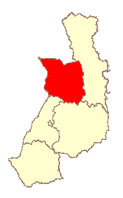
Antsalova is a district in western Madagascar. It is a part of Melaky Region and borders the districts of Maintirano in north, Morafenobe in northeast, Miandrivazo in east and Belon'i Tsiribihina in south. The area is 7,195 km2 (2,778 sq mi) and the population was estimated to be 30,062 in 2001.

Tsingy de Namoroka National Park, formerly known as Tsingy de Namoroka Strict Nature Reserve, is a national park located in the northwestern part of Madagascar in the Mahajanga Province, specifically, the Soalala District.

Tsimanampetsotsa National Park also spelt Tsimanampetsotse, and known as Tsimanampetsotsa Nature Reserve is a 432 km2 national park on the south-west coast of Madagascar in the region Atsimo-Andrefana. The park is 90 kilometres (56 mi) south of Toliara and 950 kilometres (590 mi) south of the capital, Antananarivo. Route Nationales (RN) 10 to Faux Cap passes the park and the nearest airport is at Toliara. The national park contains and is named after Lake Tsimanampetsotsa.

Andranomena Special Reserve is a wildlife reserve in Menabe Region, western Madagascar, near the city of Morondava and the rural commune of Bemanonga.

Despite a high potential for tourism, tourism in Madagascar is underdeveloped. Madagascar's tourist attractions include its beaches and biodiversity. The island's endemic wildlife and forests are unique tourist attractions. However, historical sites, craftsmen communities, and relaxed cities make it a favorite with return travellers.

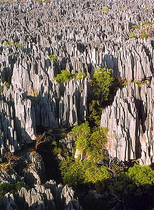
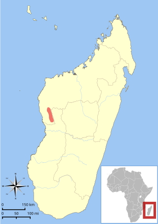
The Tsingy de Bemaraha National Park is a national park located in northwest Madagascar. It is mainly within the boundaries of Antsalova District, with a small part in the northeast falling within Morafenobe District. The national park centers on two geological formations: the Great Tsingy and the Little Tsingy. Together with the adjacent Tsingy de Bemaraha Strict Nature Reserve, the National Park is a UNESCO World Heritage Site.
Morondava District is a district in the Menabe region in eastern Madagascar. Its capital is Morondava. The district has an area of 5,691 km2 (2,197 sq mi), and the estimated population in 2020 was 157,596.
The Kirindy Forest is a private nature reserve situated in western Madagascar, about 50 km northeast of the town of Morondava, near Ambivy. The forest reserve falls within the boundaries of the Kirindy Mitea National Park, which spreads further to the south.
Belon'i Tsiribihina is a district of the Menabe region of Madagascar and borders the Miandrivazo region to the east, the Mahabo to the southeast, and the Morondava to the southwest. The district has an area of 8,038 km2 (3,103 sq mi), and the estimated population in 2020 was 138,775.
The Bemaraha Formation is a Middle Jurassic geological formation of the Morondava Basin of Madagascar. The lime mudstones, grainstones and limestones of the formation were deposited in lagoonal and reefal environments. Fossils of groups of invertebrates and theropod and sauropod tracks have been found in the formation. The Sahalaly River tracksite yielded a single trackway belonging to a quadrupedal dinosaur, possibly a sauropod. Sauropod tracks are rare, making up as little as 1 percent of the present sample. The best-preserved tracks are assigned to the ichnogenus Kayentapus.