
The Madagascar lowland forests or Madagascar humid forests are a tropical moist broadleaf forest ecoregion found on the eastern coast of the island of Madagascar, home to a plant and animal mix that is 80 to 90% endemic, with the forests of the eastern plain being a particularly important location of this endemism. They are included in the Global 200 list of outstanding ecoregions.

The Madagascar subhumid forests are a tropical moist broadleaf forest ecoregion that covers most of the Central Highlands of the island of Madagascar. They are included in the WWF's Global 200 list of outstanding ecoregions. Most of the original habitats have been lost due to human pressure.

The Madagascar dry deciduous forests represent a tropical dry forest ecoregion situated in the western and northern part of Madagascar. The area has high numbers of endemic plant and animal species but has suffered large-scale clearance for agriculture. They are among the world's richest and most distinctive dry forests and included in the Global 200 ecoregions by the World Wide Fund. The area is also home to distinctive limestone karst formations known as tsingy, including the World Heritage Site of Bemaraha.
The Anjajavy's Protected Area is located on a peninsula of the town of Antonibe, in the district of Analalava and in the north-west region of Madagascar. It is part of the Sofia region of the independent province of Mahajanga and its position is between 47°13’ at 44°22’ of longitude east and 14°58 at 15°07’ of latitude south..
Makira Natural Park is a nature reserve in Madagascar's Northeastern region. In 2001, the Madagascar Ministry of Environment and Forests, in collaboration with the Wildlife Conservation Society (WCS), launched a program to create the 372,470 the Makira Forest Protected Area, with first temporary legal protections provided in 2005 as Makira Protected Area. Formally established as Makira Natural Park in 2012, the site is one of the largest of Madagascar’s protected areas and encompasses 372,470 hectares of strictly protected forest buffered by more than 350,000 hectares of community-managed forests. The Makira Natural Park is managed by WCS on behalf of the Government of Madagascar under a delegated management contract.

Andringitra National Park is a national park in the Haute Matsiatra region of Madagascar, 47 kilometres (29 mi) south of Ambalavao. The park was established in 1999 and is managed by the Madagascar National Parks Association. It was inscribed in the World Heritage Site in 2007 as part of the Rainforests of the Atsinanana.

The Kirindy Mitea National Park is a national park on the coast of the Mozambique Channel, in south-west Madagascar. The 72,200 hectares park contains many endemic animals and plants and claims to have the greatest density of primates in the world.
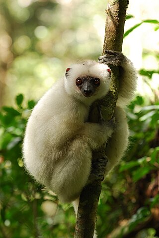
Marojejy National Park is a national park in the Sava region of northeastern Madagascar. It covers 55,500 ha (214 sq mi) and is centered on the Marojejy Massif, a mountain chain that rises to an elevation of 2,132 m (6,995 ft). Access to the area around the massif was restricted to research scientists when the site was set aside as a strict nature reserve in 1952. In 1998, it was opened to the public when it was converted into a national park. It became part of the World Heritage Site known as the Rainforests of the Atsinanana in 2007. "Unique in the world, a place of dense, jungly rainforests, sheer high cliffs, and plants and animals found nowhere else on earth", Marojejy National Park has received plaudits in the New York Times and Smithsonian Magazine for its natural beauty and rich biodiversity that encompasses critically endangered members of the silky sifaka. To that end, a global consortium of conservation organizations, including the Lemur Conservation Foundation, Duke Lemur Center and Madagascar National Parks, have sought to promote research and conservation programs in Marojejy National Park, neighboring Anjanaharibe-Sud Reserve and Antanetiambo Private Reserve, to protect the endemic flora and fauna that reside in northeastern Madagascar. In addition, these organizations have implemented a variety of community-based initiatives to mitigate human encroachment on the park, such as poaching and selective logging, by encouraging local communities to engage in afforestation and silvicultural initiatives to promote a sustainable alternative to mining, slash-and-burn agriculture, and wood collection.

Tsimanampetsotsa National Park also spelt Tsimanampetsotse, and known as Tsimanampetsotsa Nature Reserve is a 432 km2 national park on the south-west coast of Madagascar in the region Atsimo-Andrefana. The park is 90 kilometres (56 mi) south of Toliara and 950 kilometres (590 mi) south of the capital, Antananarivo. Route Nationales (RN) 10 to Faux Cap passes the park and the nearest airport is at Toliara. The national park contains and is named after Lake Tsimanampetsotsa.

Zombitse-Vohibasia is a national park in the Atsimo-Andrefana region of south-west Madagascar. It is 147 kilometres (91 mi) north-east of the town of Toliara on the National road 7.
Ambatovaky Special Reserve is a tropical rainforest and wildlife reserve in the north-east of Madagascar. It is designated by Bird Life International as an Important Bird Area for the large number of endemic species of birds.
Ambohijanahary Special Reserve is a wildlife reserve in the regions of Menabe and Melaky in Madagascar. The reserve was created in 1958 to protect the sclerophyllous forest between Tsiroanomandidy and Maintirano, as well as protecting the many endemic species of plants and animals.
Anjanaharibe-Sud Special Reserve is a wildlife reserve in the north-east of Madagascar. The reserve was designated in 1958 and contains some of the last intact primary rainforest, along with several, rare and endemic animals and plants. The area was nominated to the UNESCO Tentative List of World Heritage Sites in Madagascar in 2008, as an extension of the rainforests of the Atsinanana.
Bemarivo Reserve is a wildlife reserve 12 km from Besalampy in the region of Melaky in the north-west of Madagascar. It was created in 1956 and covers an area of 12,080 hectares. The reserve is known for its fauna especially endemic birds.
Kalambatritra Special Reserve is a wildlife reserve in southern Madagascar. It is to the north of Andohahela National Park, south-west of the Manombo Special Reserve and contains many endemic species, including forty-five endemic bird species.
Mangerivola Special Reserve is a wildlife reserve in the east of Madagascar. It was established in 1958 and is a hotspot for bird-watchers due to the one hundred species found there, including 63 endemics and many local endemics. There are also seven species of lemur and rare chameleons such as the Lance-nosed chameleon which is registered as endangered on the IUCN Red List of Threatened Species.
Maningoza Special Reserve is a 9,826 hectares wildlife reserve near Besalampy in Madagascar. It was created in 1956 to protect the many endemic plants and animals, and it also contains some of the last remaining areas of dry deciduous forest on the island.
Manongarivo Reserve is a wildlife reserve in the North-West of Madagascar in the region of Diana.
Marotandrano Special Reserve is a wildlife reserve in Mandritsara, Sofia Region, Madagascar. It is 10 km from Marotandrano and 42 km from Mandritsara.

The Madagascar succulent woodlands are a xeric shrublands ecoregion in southwestern and central western Madagascar. Native plants survive in the arid climate and long dry season with adaptations like succulent leaves, water storing trunks, photosynthetic stems, and dropping leaves during the dry season. The ecoregion is threatened by various human activities.

