Menabe Antimena

Last updated
Menabe Antimena
IUCN category V (protected landscape/seascape) [1]
Adansonia grandidieri Pat Hooper.jpg
Madagascar physical map.svg
Red pog.svg
Location of Menabe Antimena in Madagascar
Location Menabe, Madagascar
Nearest city Morondava
Coordinates 19°56′37″S44°40′46″E / 19.94361°S 44.67944°E / -19.94361; 44.67944
Area2,094.61 km2 (808.73 sq mi)
DesignationPaysage Harmonieux Protégé (harmonious protected landscape)
DesignatedJuly 2007
Official nameZones humides de Bedo
Designated12 May 2007
Reference no.1686 [2]
Official nameMangroves de Tsiribihina
Designated22 May 2017
Reference no.2302 [3]

Menabe Antimena is a protected area in Menabe region of western Madagascar.

Contents

Menabe Antimena is on the west coast of Madagascar, south of the Mania River. [1] It covers an area of dry forest, succulent woodland, mangroves, and secondary grassland and scrub. It includes the northern portion of the Kirindy Forest [4] and the Avenue of the Baobabs.

Large areas have been illegally logged, burned, and converted to maize fields, which threatens the area's wildlife, including the critically endangered Madame Berthe's mouse lemur (Microcebus berthae), the smallest primate in the world. [4]

Tsiribihina mangroves

The Tsiribihina mangroves extend along the coast around the mouth of the Tsiribihina River. The mangroves are mostly within the reserve, with the portion north of the river outside it. There are about 20,000 hectares of mangroves, 8.5% of Madagascar's mangroves by area, along with lagoons, marshes, sandbanks, salt flats, and mud flats. About 40,000 waterbirds from 44 species live in the wetlands, including large numbers of lesser crested tern (Thalasseus bengalensis), lesser flamingo (Phoeniconaias minor), greater flamingo (Phoenicopterus roseus), crab-plover (Dromas ardeola), curlew sandpiper (Calidris ferruginea) and sanderling (Calidris alba). Threatened species include the Madagascar fish eagle (Haliaeetus vociferoides), Madagascar teal (Anas bernieri), Malagasy sacred ibis (Threskiornis bernieri), Madagascar heron (Ardea humbloti), Madagascar plover (Charadrius thoracicus), and Madagascar pratincole (Glareola ocularis). [3]

The wetland is also home to the lemur Verreaux's sifaka (Propithecus verreauxi) the Madagascan flying fox (Pteropus rufus), and the critically endangered hawksbill sea turtle (Eretmochelys imbricata). [3]

The Tsiribihina mangroves (Mangroves de Tsiribihina) and were declared a Ramsar site (wetland of international importance) in 2017, with an area of 47,218 ha. Deforestation upstream threatens the wetlands and offshore coral reefs with siltation. [3]

Bedo wetlands

The Bedo wetlands (Zones humides de Bedo) are also within the Menabe Antimena protected area. They are located on the lower Mandroatse River, south of the Tsiribihina and north of the Morondava River, at the western edge of the Marandravy and Analabe forests. The wetlands are habitat for water birds, including the vulnerable Madagascar plover (Charadrius thoracicus) and endangered Madagascar teal (Anas bernieri) and Madagascar heron (Ardea humbloti). The Mandroatse River is home to the Marakely fish ( Paratilapia polleni ), a threatened Madagascar endemic, and the Nile crocodile. [2]

Local people depend on the wetlands for fish and bullrushes ( Typha angustifolia ), which are harvested for basketry and house roofs. [2]

The Bedo wetlands were declared a Ramsar site in 2007, covering an area of 1,692 ha. [2]

Related Research Articles

<span class="mw-page-title-main">Ribble and Alt Estuaries</span>

The Ribble and Alt Estuaries lie on the Irish Sea coast of the ceremonial counties of Lancashire and Merseyside in the traditional county of Lancashire in north-west England, and form the boundaries of a number of conservation schemes.

<span class="mw-page-title-main">Ankarafantsika National Park</span>

Ankarafantsika National Park is a national park near Andranofasika in the Boeny Region of Madagascar. The closest city is Majunga 115 kilometres (71 mi) north of the park. Ankarafantsika is mostly tropical in climate type. The Sakalava people are the predominant ethnic group living and farming here. The greater big-footed mouse lives in the park and is not known anywhere else.

<span class="mw-page-title-main">Menabe</span> Region in Madagascar

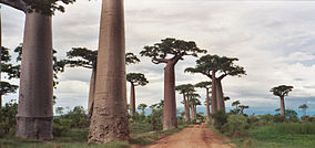
Menabe is a region in western Madagascar, with its capital at Morondava. It covers an area of 46,121 square kilometres, and its population was 700,577 in 2018. The population mostly belongs to the Sakalava ethnic group. The region is named after the 18th-century Sakalava Kingdom of Menabe. The name "Menabe", in turn, means "big red", after the color of laterite rock that dominates the landscape.

<span class="mw-page-title-main">Lagoa do Peixe National Park</span> Brazil national park

Lagoa do Peixe National Park is a national park in the state of Rio Grande do Sul, Brazil. It was created in 1986 to protect a wintering zone for migratory birds along the Lagoa dos Patos, the estuary of the Guaiba river or Guaíba Lake about 200 kilometres (120 mi) south of Porto Alegre.

<span class="mw-page-title-main">Madagascar plover</span> Species of bird

The Madagascar plover, also known as the black-banded plover, is a small monogamous shorebird in the family Charadriidae, native to western Madagascar. It inhabits shores of lagoons, coastal grasslands, and breeds in salt marshes. These plovers mainly nest in open grassland and dry mudflats surrounding alkaline lakes. The species is classified as vulnerable by the IUCN because of its low breeding success, slow reproductive rate, and weak adaptation to increasing habitat loss, leading to declining population numbers.

<span class="mw-page-title-main">Sakalava rail</span> Species of bird

The Sakalava rail is a species of bird in the family Rallidae. It is endemic to western Madagascar. This bird is small with brown upperpart feathers, grey underparts, a yellow bill and red legs.

<span class="mw-page-title-main">Cananéia-Iguape-Peruíbe Environmental Protection Area</span>

Cananéia-Iguape-Peruíbe Environmental Protection Area is a protected area in the State of São Paulo, Brazil. It has been designated as a Ramsar site since 2017.

<span class="mw-page-title-main">Kirindy Mitea National Park</span>

The Kirindy Mitea National Park is a national park on the coast of the Mozambique Channel, in south-west Madagascar. The 72,200 hectares park contains many endemic animals and plants and claims to have the greatest density of primates in the world.

<span class="mw-page-title-main">Tsimanampetsotsa National Park</span>

Tsimanampetsotsa National Park also spelt Tsimanampetsotse, and known as Tsimanampetsotsa Nature Reserve is a 432 km2 national park on the south-west coast of Madagascar in the region Atsimo-Andrefana. The park is 90 kilometres (56 mi) south of Toliara and 950 kilometres (590 mi) south of the capital, Antananarivo. Route Nationales (RN) 10 to Faux Cap passes the park and the nearest airport is at Toliara. The national park contains and is named after Lake Tsimanampetsotsa.

Bemarivo Reserve is a wildlife reserve in the north-west of Madagascar. It was created in 1956 and covers an area of 12,080 hectares. The reserve is known for its fauna especially endemic birds.

<span class="mw-page-title-main">Bao Bolong Wetland Reserve</span>

Bao BolongWetland Reserve is a national park in The Gambia. Established in 1996 it covers 220 square kilometres.

<span class="mw-page-title-main">Forests in Odisha</span>

Odisha, one of the 28 states of India, has two basic kinds of forest: in the northeast region of the state the forest is classified as the tropical-moist-deciduous type, blanketing hills, plateaus and other high-altitude isolated areas; in the southwest the tropical-dry-deciduous variety dominate.

<span class="mw-page-title-main">Rietvlei Wetland Reserve</span> Nature reserve in Table View, Western Cape, South Africa.

The Rietvlei Wetland Reserve is a 663-hectare (1,640-acre) nature reserve situated in Table View, Western Cape, South Africa. It is managed by the City of Cape Town's Environmental Resource Management Department.

<span class="mw-page-title-main">Tsiribihina River</span> River in Madagascar

The Tsiribihina is a river of western Madagascar.

<span class="mw-page-title-main">Madagascar succulent woodlands</span>

The Madagascar succulent woodlands are a xeric shrublands ecoregion in southwestern and central western Madagascar. Native plants survive in the arid climate and long dry season with adaptations like succulent leaves, water storing trunks, photosynthetic stems, and dropping leaves during the dry season. The ecoregion is threatened by various human activities.

References

  1. 1 2 Protected Area Profile for Menabe Antimena from the World Database on Protected Areas. Accessed 9 September 2022.
  2. 1 2 3 4 "Zones humides de Bedo". Ramsar Sites Information Service. Retrieved 9 September 2022.
  3. 1 2 3 4 "Mangroves de Tsiribihina". Ramsar Sites Information Service. Retrieved 9 September 2022.
  4. 1 2 Ratsimbazafy, Rondro (6 September 2019). "Madagascar forest destruction wiping out humans' tiniest relative". Reuters. Retrieved 9 September 2022.