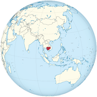
Cambodia is a country in mainland Southeast Asia. It borders Thailand, Laos, Vietnam, the Gulf of Thailand and covers a total area of approximately 181,035 km2 (69,898 sq mi). The country is situated in its entirety inside the tropical Indomalayan realm and the Indochina Time zone (ICT).

The Zambezi is the fourth-longest river in Africa, the longest east-flowing river in Africa and the largest flowing into the Indian Ocean from Africa. Its drainage basin covers 1,390,000 km2 (540,000 sq mi), slightly less than half of the Nile's. The 2,574 km (1,599 mi) river rises in Zambia and flows through eastern Angola, along the north-eastern border of Namibia and the northern border of Botswana, then along the border between Zambia and Zimbabwe to Mozambique, where it crosses the country to empty into the Indian Ocean.

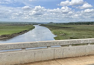
The Mitchell River is a river in Far North Queensland, Australia. The river rises on the Atherton Tableland about 50 kilometres (31 mi) northwest of Cairns and flows about 750 kilometres (470 mi) northwest across Cape York Peninsula from Mareeba to the Gulf of Carpentaria.

The Pantanal is a natural region encompassing the world's largest tropical wetland area, and the world's largest flooded grasslands. It is located mostly within the Brazilian state of Mato Grosso do Sul, but it extends into Mato Grosso and portions of Bolivia and Paraguay. It sprawls over an area estimated at between 140,000 and 195,000 km2. Various subregional ecosystems exist, each with distinct hydrological, geological and ecological characteristics; up to 12 of them have been defined.

Lake Alaotra is the largest lake in Madagascar, located in Alaotra-Mangoro Region and on the island's northern central plateau. Its basin is composed of shallow freshwater lakes and marshes surrounded by areas of dense vegetation. It forms the center of the island's most important rice-growing region. It is a rich habitat for wildlife, including some rare and endangered species, as well as an important fishing ground. Lake Alaotra and its surrounding wetlands cover 7,223 square kilometres (2,789 sq mi), and include a range of habitats, including open water, reedbeds, marshes, and rice paddies. The lake itself covers 900 km2 (350 sq mi). Lake Alaotra was declared a wetland of international importance under the international Ramsar Convention on February 2, 2003.

The Peace–Athabasca Delta, located in northeast Alberta, is the largest freshwater inland river delta in North America. It is located partially within the southeast corner of Wood Buffalo National Park, Canada's largest national park, and also spreads into the Regional Municipality of Wood Buffalo, west and south of the historical community of Fort Chipewyan. The delta encompasses approximately 321,200 ha, formed where the Peace and Athabasca rivers converge on the Slave River and Lake Athabasca. The delta region is designated a wetland of international importance and a UNESCO World Heritage Site. The region is large enough that it is considered one of twenty distinct natural subregions of Alberta by the provincial government's Natural Regions Committee.
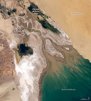
The Colorado River Delta is the region where the Colorado River flows into the Gulf of California in eastern Mexicali Municipality in the north of the state of Baja California in northwesternmost Mexico. The delta is part of a larger geologic region called the Salton Trough. Historically, the interaction of the river's flow and the ocean's tide created a dynamic environment, supporting freshwater, brackish, and saltwater species. Within the delta region, the river split into multiple braided channels and formed a complex estuary and terrestrial ecosystems. The use of water upstream and the accompanying reduction of freshwater flow has resulted in the loss of most of the wetlands of the area, as well as drastic changes to the aquatic ecosystems. However, a scheme is currently in place which aims to rejuvenate the wetlands by releasing a pulse of water down the river delta.

The Mangoky River is a 564-kilometer-long (350 mi) river in Madagascar in the regions of Atsimo-Andrefana and Anosy. It is formed by the Mananantanana and the Matsiatra. Another important affluent is the Zomandao River.

The Madagascar dry deciduous forests represent a tropical dry forest ecoregion situated in the western and northern part of Madagascar. The area has high numbers of endemic plant and animal species but has suffered large-scale clearance for agriculture. They are among the world's richest and most distinctive dry forests and included in the Global 200 ecoregions by the World Wide Fund. The area is also home to distinctive limestone karst formations known as tsingy, including the World Heritage Site of Bemaraha.

The Rokel River is the largest river in the Republic of Sierra Leone in West Africa. The river basin measures 10,622 km2 (4,101 sq mi) in size, with the drainage divided by the Gbengbe and Kabala hills and the Sula Mountains. The estuary which extends over an area of 2,950 km2 (1,140 sq mi) became a Ramsar wetland site of importance in 1999.

Menabe Antimena is a protected area in Menabe region of western Madagascar. It belongs to the municipalities of Tsimafana, Beroboka, Bemanonga, Belon'i Tsiribihina, and Tsaraotana.

The Mahavavy-Kinkony Reserve is a protected area consisting principally of dry deciduous forest and wetlands in the western part of Madagascar.
The Malagarasi River is a river in western Tanzania, flowing through Kigoma Region, although one of its tributaries comes from southeastern Burundi. The river also forms the western border of Tabora Region, the southern border of Kagera Region and the southwestern border of Geita Region. It is the second-longest river in Tanzania behind the Rufiji—Great Ruaha, and has the largest watershed of any river flowing into Lake Tanganyika. The Malagarasi-Muyovozi Wetlands are a designated a Ramsar site. Local tribes have nicknamed the Malagarasi as "the river of bad spirits".

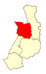
Antsalova is a district in western Madagascar. It is a part of Melaky Region and borders the districts of Maintirano in north, Morafenobe in northeast, Miandrivazo in east and Belon'i Tsiribihina in south. The area is 7,195 km2 (2,778 sq mi) and the population was estimated to be 30,062 in 2001.

Bao BolongWetland Reserve is a protected area in The Gambia. Established in 1996, it covers 296.5 square kilometres.

Odisha is one of the 28 states in the Republic of India. Odisha is located in the eastern part of the Indian peninsula and the Bay of Bengal lies to its East while Chhattisgarh shares its border in the west and north-west. The state also shares geographic boundaries with West Bengal in the north-east, Jharkhand in the north and Andhra Pradesh in the south. The state is spread over an area of 1,55,707 km2 and extends for 700 km from north to south and 500 kilometres from east to west. Its coastline is 450 km long. The state is divided into 30 districts which are further subdivided into 314 blocks.

The Jiwani Coastal Wetland is a wetland located in Balochistan, Pakistan, near the town of Jiwani. The site is one of the 19 Ramsar sites in Pakistan and was inducted in 2001.
The Tana River Delta Ramsar Site is a wetland on the Tana River protected under the Ramsar Convention located in the Coast Province of Kenya. It was gazetted as Kenya's 6th Ramsar Site.
Belon'i Tsiribihina is a district of the Menabe region of Madagascar and borders the Miandrivazo region to the east, the Mahabo to the southeast, and the Morondava to the southwest. The district has an area of 8,038 km2 (3,103 sq mi), and the estimated population in 2020 was 138,775.

The Sakeny River is a river in Western Madagascar. It is a tributary of the Tsiribihina River.


