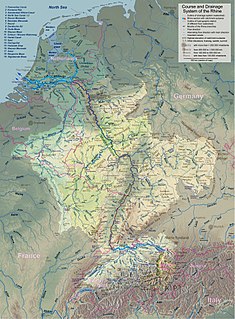
The Rhine is one of the major European rivers, which has its sources in Switzerland and flows in a mostly northerly direction through Germany and the Netherlands, emptying into the North Sea. The river begins in the Swiss canton of Graubünden in the southeastern Swiss Alps, forms part of the Swiss-Liechtenstein, Swiss-Austrian, Swiss-German and then the Franco-German border, then flows through the German Rhineland and the Netherlands and eventually empties into the North Sea.

Iguazú Falls or Iguaçu Falls are waterfalls of the Iguazu River on the border of the Argentine province of Misiones and the Brazilian state of Paraná. Together, they make up the largest waterfall in the world. The falls divide the river into the upper and lower Iguazu. The Iguazu River rises near the heart of the city of Curitiba. For most of its course, the river flows through Brazil; however, most of the falls are on the Argentine side. Below its confluence with the San Antonio River, the Iguazu River forms the border between Argentina and Brazil.

The River Severn is the longest river in Great Britain at a length of 220 miles (354 km). With an average discharge of 107 m3/s (3,800 cu ft/s) at Apperley, Gloucestershire, it has by far the greatest water flow in England and Wales.

The Saône is a river of eastern France. It is a right tributary of the Rhône, rising at Vioménil in the Vosges department and joining the Rhône in Lyon, just south of the Presqu'île.
The Windhoek Declaration for the Development of a Free, Independent and Pluralistic Press, short: Windhoek Declaration is a statement of press freedom principles by African newspaper journalists in 1991. The Declaration was produced at a UNESCO seminar, "Promoting an Independent and Pluralistic African Press," held in Windhoek, the capital of Namibia, from 29 April to 3 May 1991.

A spring is a point at which water flows from an aquifer to the Earth's surface. It is a component of the hydrosphere.
In hydrology, discharge is the volumetric flow rate of water that is transported through a given cross-sectional area. It includes any suspended solids (e.g. sediment), dissolved chemicals (e.g. CaCO3(aq)), or biologic material (e.g. diatoms) in addition to the water itself.

Nizhnyaya Tunguska is a river in Siberia, Russia, that flows through the Irkutsk Oblast and the Krasnoyarsk Krai. The river is a right tributary of the Yenisei joining it at Turukhansk. Settlements on the river include Tura, Yukti and Simenga. The ice-free period on the Lower Tunguska starts in mid-June and ends in the first half of October. The river forms the western limit of the Lena Plateau.

The Perito Moreno Glacier is a glacier located in the Los Glaciares National Park in southwest Santa Cruz Province, Argentina. It is one of the most important tourist attractions in the Argentinian Patagonia.

The Drin or Drim is a river in Southern and Southeastern Europe with two distributaries one discharging into the Adriatic Sea and the other one into the Buna River. Its catchment area extends across Albania, Kosovo, Greece, Montenegro and North Macedonia. The river and its tributaries form the Gulf of Drin, an ocean basin that encompasses the northern Albanian Adriatic Sea Coast.
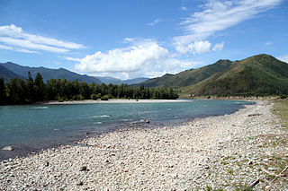
The Katun River is a river in the Altai Republic and the Altai Krai of Russia. It forms the Ob River as it joins the Biya River some 19 kilometres (12 mi) southwest of Biysk. The Katun River is 688 kilometres (428 mi) long, and its drainage basin covers 60,900 square kilometres (23,500 sq mi). It originates in the Katun glaciers on the southern slope of Belukha Mountain. The river freezes up in late November or early December and breaks up in early or mid-April. The Katun River has a few tributaries: Argut River, Chuya River, Koksa River and Sema River. The river is navigable.

The Falémé River is a river in West Africa. The Falémé arises in northern Guinea and flows in a north-northeast direction to Mali, forming a short portion of the border between Guinea and Senegal. It turns north and then forms a portion of the border between Mali and Senegal, before joining the Sénégal River 50 km upstream of the town of Bakel in Senegal.

The Radziwiłł Chronicle is one of the Old East Slavic illuminated manuscript held by the Library of the Russian Academy of Sciences in Saint Petersburg. It is a 15th-century copy of a 13th-century original. Its name is derived from the Princes Radziwiłł of Grand Duchy of Lithuania, who kept it in their Nesvizh Castle in the 17th and 18th centuries.

The Yarkand River is a river in the Xinjiang Uyghur Autonomous Region of western China, originating in the Karakoram range and flowing into the Tarim River, with which it is sometimes identified. However, in modern times, the Yarkand river drains into the Shangyou Reservoir and exhausts its supply without reaching the Tarim river. The Yarkand River is approximately 1097 km (600 mi) in length, with an average discharge of 210 m3/s (7,400 cu ft/s).

Floodgates, also called stop gates, are adjustable gates used to control water flow in flood barriers, reservoir, river, stream, or levee systems. They may be designed to set spillway crest heights in dams, to adjust flow rates in sluices and canals, or they may be designed to stop water flow entirely as part of a levee or storm surge system. Since most of these devices operate by controlling the water surface elevation being stored or routed, they are also known as crest gates. In the case of flood bypass systems, floodgates sometimes are also used to lower the water levels in a main river or canal channels by allowing more water to flow into a flood bypass or detention basin when the main river or canal is approaching a flood stage.
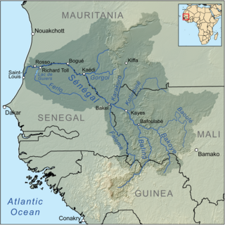
The Bakoy or Bakoye River is a river in West Africa. It runs through Guinea and Mali and joins with the Bafing River to form the Sénégal River at Bafoulabé in the Kayes Region of western Mali. In Manding languages, Bakoye signifies 'white river', Bafing 'black river' and Baloué 'red river'.
Miandrivazo is a town and commune in Madagascar. It is situated at the Mahajilo River and belongs to the district of Miandrivazo, which is a part of Menabe Region. The population of the commune was estimated to be approximately 108,000 in 2001 commune census.

A river is a natural flowing watercourse, usually freshwater, flowing towards an ocean, sea, lake or another river. In some cases a river flows into the ground and becomes dry at the end of its course without reaching another body of water. Small rivers can be referred to using names such as stream, creek, brook, rivulet, and rill. There are no official definitions for the generic term river as applied to geographic features, although in some countries or communities a stream is defined by its size. Many names for small rivers are specific to geographic location; examples are "run" in some parts of the United States, "burn" in Scotland and northeast England, and "beck" in northern England. Sometimes a river is defined as being larger than a creek, but not always: the language is vague.

The San Juan River is an important river of Colombia that flows into the Pacific Ocean through the Chocó Department. It is approximately 380 kilometres (240 mi) and drains a watershed of 15,000 square kilometres (5,800 sq mi). The river drains into a large delta that covers nearly 300 square kilometres (120 sq mi). The average discharge of Rio San Juan is 77,000 cu ft/s
RheinBlick2050 is an environmental science research project on the impacts of regional climate change on discharge of the Rhine River and its major tributaries in Central Europe. The project runtime was from January 2008 until September 2010, initiated by and coordinated on behalf of the International Commission for the Hydrology of the Rhine Basin (CHR).

