
Madagascar, officially the Republic of Madagascar, is an island country comprising the island of Madagascar and numerous smaller peripheral islands. Lying off the southeastern coast of Africa, it is the world's fourth largest island, the second-largest island country and the 46th largest country in the world. Its capital and largest city is Antananarivo.

Madagascar is a large island in the Indian Ocean located 400 kilometres (250 mi) off the eastern coast of Southern Africa, east of Mozambique. It has a total area of 587,040 square kilometres (226,660 sq mi) with 581,540 square kilometres (224,530 sq mi) of land and 6,900 square kilometres (2,700 sq mi) of water. Madagascar is the fourth-largest island in the world. The highest point is Maromokotro, in the Tsaratanana Massif region in the north of the island, at 2,876 metres (9,436 ft).

The ecoregions of Madagascar, as defined by the World Wildlife Fund, include seven terrestrial, five freshwater, and two marine ecoregions. Madagascar's diverse natural habitats harbour a rich fauna and flora with high levels of endemism, but most ecoregions suffer from habitat loss.

The Mangoky River is a 564-kilometer-long (350 mi) river in Madagascar in the regions of Atsimo-Andrefana and Anosy. It is formed by the Mananantanana and the Matsiatra. Another important affluent is the Zomandao River.
Sava is a region in northern Madagascar. Its capital is Sambava. Until 2009 Sava belonged to Antsiranana Province. The region is situated at the northern part of the east coast of Madagascar. It is bordered by the region Diana to the north, Sofia to the west, and Analanjirofo to the south. As of 2018, its population was 1,123,013 and the total area is 25,518 km2 (9,853 sq mi). The region contains wild areas such as Marojejy National Park.

Vakinankaratra is a region in central Madagascar. The capital of the region is Antsirabe. Vakinankaratra covers an area of 16,599 kilometres, and had a population of 2,074,358 in 2018.

The Madagascan big-headed turtle is a turtle native to the waters of permanent slow moving rivers and lakes in western Madagascar. These turtles are critically endangered and have been evaluated to be the most endangered turtle in the world by a 2018 review. Due to its ancient origins and threatened status, it is ranked as #1 on the EDGE of Existence programme's list of priority reptiles.

Betsiboka River is a 525-kilometre (326 mi) long river in central-north Madagascar. It flows northwestward and empties to Bombetoka Bay, forming a large delta. It originates to the east of Antananarivo. The river is surrounded in mangroves. The river is distinctive for its red-coloured water, which is caused by river sediments. The river carries an enormous amount of reddish-orange silt to the sea. Much of this silt is deposited at the mouth of the river or in the bay.

Atsimo-Atsinanana is a region in Madagascar. Its capital is Farafangana. The region used to be part of the Fianarantsoa Province.

Menabe Antimena is a protected area in Menabe region of western Madagascar. It belongs to the municipalities of Tsimafana, Beroboka, Bemanonga, Belon'i Tsiribihina, and Tsaraotana.

Vohemar District is a district in northern Madagascar. It is a part of Sava Region and borders the districts of Sambava to the south, Ambilobe to the west and Antsiranana II to the north. The area is 8,268.55 km2 (3,193 sq mi) and the population was estimated to be 264,236 in 2020. Its capitol is Vohemar.

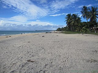
Atsinanana is a coastal region in eastern Madagascar. It borders Analanjirofo region in the north, Alaotra-Mangoro in the west, Vakinankaratra and Amoron'i Mania in the southwest, and Vatovavy in the south. The region contains over 285km of coastline, which includes many beaches and cultural heritage sites.

Saint Augustin is a rural municipality in Madagascar. It belongs to the district of Toliara II, which is a part of Atsimo-Andrefana Region. The population of the commune was estimated to be approximately 15,000 in 2001 commune census. The mouth of the Onilahy River is near the town.

The Tsiribihina is a river of western Madagascar.
The Mangoro River is the largest river on the east coast of Madagascar by basin size and water volume, and is 300 km in length.

The Onive River is a river in eastern Madagascar. It flows down from the Ankaratra massif, and is the largest tributary of the Mangoro River.

The Nosivolo River is a river in eastern Madagascar and a primary tributary of the Mangoro River. It begins east of Fandriana. The village of Marolambo, capital of the Marolambo District in the Atsinanana region, is located along the river at the junction with the Sandranamby River.

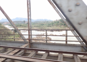
Route nationale 5a is a secondary highway in Madagascar of 406 km, running from Ambilobe to Antalaha. It crosses the regions of Diana and Sava.
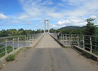
The Fanambana Bridge is situated at the Fanambana River on Route nationale 5a between Vohemar and Sambava in Sava, Madagascar. This bridge is a cable-stayed bridge with fan system, completed in 1964.


