
In geography and geology, a cliff is a vertical, or nearly vertical, or over-shapey rock exposure. Cliffs are formed by the processes of weathering and erosion. Cliffs are common on coasts, in mountainous areas, escarpments and along rivers. Cliffs are usually formed by rock that is resistant to weathering and erosion. Sedimentary rocks most likely to form cliffs include sandstone, limestone, chalk, and dolomite. Igneous rocks such as granite and basalt also often form cliffs.
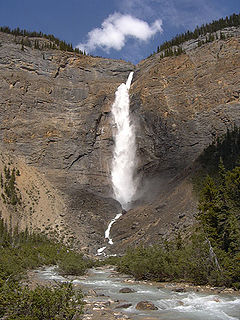
Yoho National Park is a national park of Canada. It is located within the Rocky Mountains along the western slope of the Continental Divide of the Americas in southeastern British Columbia, bordered by Kootenay National Park to the south and Banff National Park to the east in Alberta. The word Yoho is a Cree expression of amazement or awe, and it is an apt description for the park's spectacular landscape of massive ice fields and mountain peaks, which rank among the highest in the Canadian Rockies.

Ponmudi also known as Kashmir of Kerala is a hill station in the Peringamala gramapanchayath of Trivandrum District of Kerala in India. It is located 22km west of vithura town, 53 km north-east of Trivandrum City, 78 km south-east of Varkala town and 69 km north-east of Kovalam Beach at an altitude of 1,100 m (3,600 ft). Ponmudi (Varayadumotta) peak is a part of the Western Ghats mountain range that runs parallel to the Arabian Sea. Ponmudi is also called Kashmir of Kerala and is a popular honeymoon destination in South India. The normal temperature of Ponmudi is between 18 and 25 °C.

The Ihosy River is a river in Fianarantsoa Province in central Madagascar. It runs down from the hills of Bekisopa, through the town of Ihosy, which provides the name of the river.

The Madagascan big-headed turtle is a turtle native to the waters of permanent slow moving rivers and lakes in western Madagascar. These turtles are critically endangered and have been evaluated to be the most endangered turtle in the world by a 2018 review. Despite their vulnerability to extinction, they are commonly eaten for food and they are still commonly shipped from Madagascar to Asia to help meet the demand of Asia's traditional medicine market. A captive breeding program has also been started to prevent the species from becoming extinct. The Turtle Conservation Fund (TCF) intends to raise US$5.6 million to cover a five-year 'Global Action Plan' which includes captive breeding and reintroduction projects, trade monitoring, new rescue centers, local conservation plans, and educational programs.

The Priest (DePriest) is a mountain in Nelson County, Virginia. The peak of the mountain is the highest point in the county. The mountain is on a spur off the main Blue Ridge Mountains, about 3.5 miles (5.5 km) east of Maintop Mountain, located in the Priest Wilderness of the George Washington National Forest.
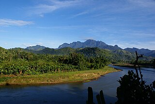
Marojejy National Park is a national park in the Sava Region of northeastern Madagascar. It covers 55,500 ha (214 sq mi) and is centered on the Marojejy Massif, a mountain chain that rises to an elevation of 2,132 m (6,995 ft). Access to the area around the massif was restricted to research scientists when the site was set aside as a strict nature reserve in 1952. In 1998, it was opened to the public when it was converted into a national park. It became part of the World Heritage Site known as the Rainforests of the Atsinanana in 2007. "Unique in the world, a place of dense, jungly rainforests, sheer high cliffs, and plants and animals found nowhere else on earth", Marojejy National Park has received plaudits in the New York Times and Smithsonian Magazine for its natural beauty and rich biodiversity that encompasses critically endangered members of the silky sifaka. To that end, a global consortium of conservation organizations, including the Lemur Conservation Foundation, Duke Lemur Center and Madagascar National Parks, have sought to promote research and conservation programs in Marojejy National Park, neighboring Anjanaharibe-Sud Reserve and Antanetiambo Private Reserve, to protect the endemic flora and fauna that reside in northeastern Madagascar. In addition, these organizations have implemented a variety of community-based initiatives to mitigate human encroachment on the park, such as poaching and selective logging, by encouraging local communities to engage in afforestation and silvicultural initiatives to promote a sustainable alternative to mining, slash-and-burn agriculture, and wood collection.

Tsaratanana Reserve is a nature reserve of Madagascar. The park is located at a high altitude and is closed to the public. The reserve provides a significant amount of water to the area, and many rivers exist in the area, such as Bemarivo river, Sambirano river and the Ramena or Mahavavy River. The reserve also has two waterfalls and thermal baths.
Anjanaharibe-Sud Reserve is a wildlife reserve in the north-east of Madagascar. The reserve was designated in 1958 and contains some of the last intact primary rainforest, along with several, rare and endemic animals and plants. The area was nominated to the UNESCO Tentative List of World Heritage Sites in Madagascar in 2008, as an extension of the rainforests of the Atsinanana.

Wells Gray Provincial Park is a large wilderness park located in east-central British Columbia, Canada. The park protects most of the southern, and highest, regions of the Cariboo Mountains and covers 5,250 square kilometres. It is British Columbia's fourth largest park, after Tatshenshini, Spatsizi and Tweedsmuir.
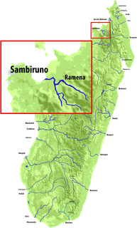
The Sambirano is a river of northwestern Madagascar in the region of Diana. It has its sources at the Maromokotra peak and flows through the Tsaratanana Reserve to the Indian Ocean. Its delta occupies 250 km2.
The Rianbavy Falls is a waterfall in the region of Ihorombe in Madagascar.
The Riandahy Falls is a waterfall in the region of Ihorombe in Madagascar.

The Mananara River is one of the main rivers in eastern Madagascar. Its mouth is located at the Indian Ocean near the city of Vangaindrano in the Atsimo-Atsinanana region.
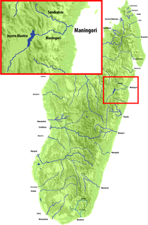
Maningory is a river in the region of Analanjirofo in north-eastern Madagascar. It takes it source in Lake Alaotra and flows into the Indian Ocean near Antakobola.
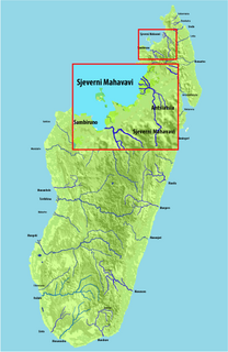
The Mahavavy or Mahavavy-Nord River is a river of northern Madagascar in the region of Diana. It has its sources at the Maromokotra peak in the Tsaratanana Massif and flows north to the Indian Ocean. The main city along the river is Ambilobe.

Windows Spotlight is a feature included by default in Windows 10 that downloads pictures and advertisements automatically from Bing and displays them when the lock screen is being shown on a computer running Windows 10. Users are occasionally given an opportunity to mark whether they wish to see more or fewer images of a similar type, and sometimes the images are overlaid with links to advertisements. In 2017, Microsoft began adding location information for many of the photographs.

Anosibe An'ala is a city in Anosibe An'ala District, Alaotra-Mangoro Region, Madagascar. It is situated at 186 km from Antananarivo and 72 km from Moramanga to which it is linked by the unpaved road RIP23 that is only suitable for 4x4 driven cars.
Ikalamavony is a small town in Haute Matsiatra region, in the hills of southern central Madagascar with a population of 35,114 in 2018. The district has a total population of 151,056 inhabitants.

The Matitanana river in Vatovavy-Fitovinany region, is located in eastern Madagascar. It flows into the Indian Ocean near Vohipeno.


