
Lake Saint Pierre is a lake in Quebec, Canada, a widening of the Saint Lawrence River between Sorel-Tracy and Trois-Rivières. It is located downstream, and northeast, of Montreal; and upstream, and southwest, of Quebec City. The end of the lake delimits the beginning of the estuary of Saint Lawrence.

The Scarpe is a river in the Hauts-de-France region of France. It is a left-bank tributary of the river Escaut (Scheldt). It is 94 km (58 mi) long. The source of the river is at Berles-Monchel near Aubigny-en-Artois. It flows through the towns of Arras, Douai and Saint-Amand-les-Eaux. The river ends at Mortagne-du-Nord where it flows into the Scheldt. Scarpe Mountain in Alberta, Canada, was named after the river. The navigable waterway and its coal barges also feature in the novels by 19th century author Émile Zola.

A transboundary protected area (TBPA) is an ecological protected area that spans boundaries of more than one country or sub-national entity. Such areas are also known as transfrontier conservation areas (TFCAs) or peace parks.

The Sangha River, a tributary of the Congo River, is located in Central Africa.

The Peace–Athabasca Delta, located in northeast Alberta, is the largest freshwater inland river delta in North America. It is located partially within the southeast corner of Wood Buffalo National Park, Canada's largest national park, and also spreads into the Regional Municipality of Wood Buffalo, west and south of the historical community of Fort Chipewyan. The delta encompasses approximately 321,200 ha, formed where the Peace and Athabasca rivers converge on the Slave River and Lake Athabasca. The delta region is designated a wetland of international importance and a UNESCO World Heritage Site. The region is large enough that it is considered one of twenty distinct natural subregions of Alberta by the provincial government's Natural Regions Committee.

The Bhoj Wetland consists of two lakes located in the city of Bhopal, the capital of the central Indian state of Madhya Pradesh. The two lakes are the Bhojtal & the Lower Lake, which lie to the west of the city center. The Bhojtal has an area of 31 km², and drains a catchment or watershed of 361 km². The watershed of the Bhojtal is mostly rural, with some urbanized areas around its eastern end. The lower lake has an area of 1.29 km². Its catchment is 9.6 km² and is mostly urbanized; the Lower Lake also receives subsurface seepage from the Bhojtal.
Onilahy is a river in Atsimo-Andrefana and Anosy, southern Madagascar. It flows down from the hills near Betroka to the Mozambique Channel. It empties at St. Augustin, and into the Bay of Saint-Augustin.
This list of national parks of Madagascar includes all officially recognized protected areas as of 2015. The protected areas network of Madagascar is managed by the Madagascar National Parks Association (PNM-ANGAP). The network includes three types of protected areas: Strict Nature Reserves, National Parks and Wildlife Reserves. At the 2003 IUCN World Parks Congress in Durban, the Malagasy President, Marc Ravalomanana, announced an initiative to more than triple the area under protection from approximately 4,200,791 acres (17,000.00 km2) to over 14,826,322 acres (60,000.00 km2). This "Durban Vision", as it has been dubbed, involved broadening the definition of protected areas in the country and legislation has been passed to allow the creation of four new categories of protected area: Natural Parks, Natural Monuments, Protected Landscapes, and Natural Resource Reserves. As well as allowing these new objectives for protected areas management, the new legislation also provided for entities other than PNM-ANGAP to manage protected areas, such as government ministries, community associations, NGOs and other civil society organizations, and the private sector.
The Kotra is a 109-kilometre-long (68 mi) river in Belarus and Lithuania. The river is an example of a rare phenomenon of river bifurcation.

Menabe Antimena is a protected area in Menabe region of western Madagascar.
Oxylapia is a genus of freshwater fish in the family Cichlidae. It contains the single species Oxylapia polli, known locally as the songatana. It is an endangered species, endemic to the Marolambo Rapids in the Nosivolo River in east-central Madagascar. It is threatened by habitat loss and sedimentation caused by deforestation. The only other monotypic cichlid genus in Madagascar is Katria, and it is restricted to the same region as Oxylapia. In 2010, the Nosivolo River was designated as a Ramsar Site. The Oxylapia is the conservation flagship species for the district capital Marolambo.
Katria is a genus of freshwater fish in the cichlid family. It contains the single species Katria katria, a vulnerable species from the Mangoro and Nosivolo Rivers in east-central Madagascar, that was formerly included in the genus Ptychochromoides. The only other monotypic cichlid genus in Madagascar is Oxylapia, and it is restricted to the same region as Katria. In 2010, the Nosivolo River was designated as a Ramsar Site. The Katria reaches about 13 centimetres (5.1 in) in length.
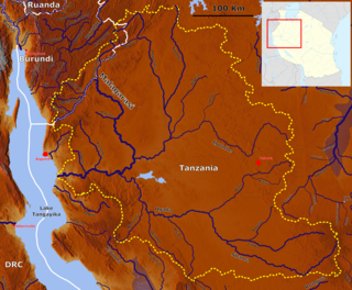
The Malagarasi River is a river in western Tanzania, flowing through Kigoma Region, although one of its tributaries comes from southeastern Burundi. The river also forms the western border of Tabora Region, the southern border of Kagera Region and the southwestern border of Geita Region. It is the second-longest river in Tanzania behind the Rufiji—Great Ruaha, and has the largest watershed of any river flowing into Lake Tanganyika. The Malagarasi-Muyovozi Wetlands are a designated a Ramsar site. Local tribes have nicknamed the Malagarasi as "the river of bad spirits".

Amoron'i Mania is a region in central Madagascar bordering Vakinankaratra Region in north, Atsinanana in northeast, Vatovavy-Fitovinany in southeast, Haute Matsiatra in south, Atsimo-Andrefana in southwest and Menabe in west.
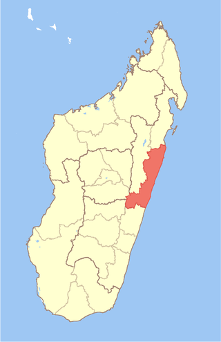
Atsinanana is a coastal region in eastern Madagascar. It borders Analanjirofo region in the north, Alaotra-Mangoro in the west, Vakinankaratra and Amoron'i Mania in the southwest, and Vatovavy and Fitovinany in south. The region contains over 285km of coastline, which includes many beaches and cultural heritage sites.
The Comoros forests is a terrestrial ecoregion which covers the Comoro Islands, which lie in the Mozambique Channel between Madagascar and East Africa. These include four main islands: Grande Comore, Anjouan and Mohéli, of the Union of the Comoros, and Mayotte, a department and region of France.

The Kanwar Taal or Kabar Taal Lake or Kabartal Wetland located in Begusarai district of Bihar, India, is Asia's largest freshwater oxbow lake. It is approximately six times the size of the Bharatpur Sanctuary. In November 2020, the Ministry of Environment, Forest and Climate Change (MoEFCC) declared it the first Ramsar site in Bihar. There are a total of 75 Ramsar Sites in India till 2022.

The Tsiribihina is a river of western Madagascar.
Marolambo is a village and commune (kaominina) located in the Atsinanana region of eastern Madagascar. It is along the Nosivolo River near the junction with the Sandranamby River, and is also the capital of the Marolambo District.
The Mangoro River is the largest river on the east coast of Madagascar by basin size and water volume, and is 300 km in length.

