
Madagascar is a large island in the Indian Ocean off the eastern coast of southern Africa, east of Mozambique. It has a total area of 587,040 square kilometres (226,660 sq mi) with 581,540 square kilometres (224,530 sq mi) of land and 5,500 square kilometres (2,100 sq mi) of water. Madagascar is the fourth largest island and the 2nd largest island country in the world. The highest point is Maromokotro, in the Tsaratanana Massif region in the north of the island, at 2,876 metres (9,436 ft). The capital Antananarivo is in the Central Highlands near the centre of the island. It has the 25th largest Exclusive Economic Zone of 1,225,259 km2 (473,075 sq mi). Madagascar is 400 kilometres east of mainland Africa.
The Global 200 is the list of ecoregions identified by the World Wide Fund for Nature (WWF), the global conservation organization, as priorities for conservation. According to WWF, an ecoregion is defined as a "relatively large unit of land or water containing a characteristic set of natural communities that share a large majority of their species dynamics, and environmental conditions". For example, based on their levels of endemism, Madagascar gets multiple listings, ancient Lake Baikal gets one, and the North American Great Lakes get none.

The ecoregions of Madagascar, as defined by the World Wildlife Fund, include seven terrestrial, five freshwater, and two marine ecoregions. Madagascar's diverse natural habitats harbour a rich fauna and flora with high levels of endemism, but most ecoregions suffer from habitat loss.

The eastern lesser bamboo lemur, also known as the gray bamboo lemur, the gray gentle lemur, and the Mahajanga lemur is a small lemur endemic to Madagascar, with three known subspecies. As its name suggests, the eastern lesser bamboo lemur feeds mainly on bamboo. The lemurs of the genus Hapalemur have more manual dexterity and hand–eye coordination than most lemurs. They are vertical climbers and jump from stalk to stalk in thick bamboo forests.
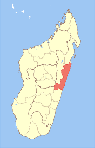
Atsinanana is a coastal region in eastern Madagascar. It borders Analanjirofo region in the north, Alaotra-Mangoro in the west, Vakinankaratra and Amoron'i Mania in the southwest, and Vatovavy in the south. The region contains over 285km of coastline, which includes many beaches and cultural heritage sites.

Saint Augustin is a rural municipality in Madagascar. It belongs to the district of Toliara II, which is a part of Atsimo-Andrefana Region. The population of the commune was estimated to be approximately 15,000 in 2001 commune census. The mouth of the Onilahy River is near the town.
List of Railway stations in Madagascar include:

The red-fronted lemur, also known as the red-fronted brown lemur or southern red-fronted brown lemur, is a species of lemur from Madagascar. Until 2001, it was considered a subspecies of the common brown lemur, E. fulvus. In 2001, E. fulvus was split into several separate species, including Eulemur rufus, in which this species was included. In 2008, E. rufus was split into two species, the red lemur and the red-fronted lemur. E. rufus covers the population on the west coast north of the Tsiribihina River and E. rufifrons covers the population on the west coast south of the Tsiribihina River and the population in eastern Madagascar. The species split was based on genetic and morphological evidence. Mitochondrial DNA analysis indicates that E. rufifrons may be more closely related to the common brown lemur, white-headed lemur and Sanford's brown lemur than it is to E. rufus.
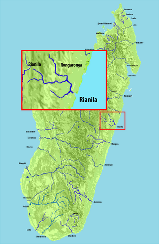
Rianila is a river in the Atsinanana region in eastern Madagascar. It flows down from the central highlands to flow into the Indian Ocean south of Brickaville at Andevoranto. Its largest tributary is the Rongaronga, which joins it near Brickaville as well as the Iaroka and Vohitra Rivers.
Marolambo is a village and commune (kaominina) located in the Atsinanana region of eastern Madagascar. It is along the Nosivolo River near the junction with the Sandranamby River, and is also the capital of the Marolambo District.

The Onive River is a river in eastern Madagascar. It flows down from the Ankaratra massif, and is the largest tributary of the Mangoro River.

The Nosivolo River is a river in eastern Madagascar and a primary tributary of the Mangoro River. It begins east of Fandriana. The village of Marolambo, capital of the Marolambo District in the Atsinanana region, is located along the river at the junction with the Sandranamby River.

The Mananara River is one of the main rivers in eastern Madagascar. Its mouth is located at the Indian Ocean near the city of Vangaindrano in the Atsimo-Atsinanana region.

Maningory is a river in the region of Analanjirofo in north-eastern Madagascar. It takes it source in Lake Alaotra and flows into the Indian Ocean near Antakobola.
The Andekaleka Dam is a gravity dam on the Vohitra river near Andekaleka in eastern Madagascar. The primary purpose of the dam is hydroelectric power generation and it diverts water from the Vohitra east into a 4 kilometres (2.5 mi) headrace tunnel where it reaches a 91 megawatts (122,000 hp) underground power station. After water charges the turbine-generators, it travels down a 500 metres (1,600 ft) tailrace tunnel before it reenters the Vohitra River. The drop in elevation between the dam and power station affords a hydraulic head of 235 metres (771 ft). The dam and power station were funded by the World Bank at a cost of US$142.1 million. It was constructed between 1978 and 1982. The power station can house up to four generators. The first two were operational in 1982 and a third in 2012. Generator one and two host Vevey and Jeumont turbines while the third is made by HEC. They all use Francis reaction turbines which typically range from 10 to 700MW and with water head operating from 10 to 600 meters

The Mananara River is one of the main rivers in north-eastern Madagascar. Its mouth is located in the Bay of Antongil, near the city of Mananara Nord in the Analanjirofo region.

The Ivondro River in Alaotra-Mangoro and Atsinanana regions, is located in central-eastern Madagascar. It drains to the eastern coast. It flows into the Canal des Pangalanes and the Indian Ocean south of Toamasina.
Ilaka Est is a rural municipality located in the Atsinanana region of eastern Madagascar, and belongs to the Vatomandry (district).
Ifasina II is a rural municipality located in the Vatomandry district of the Atsinanana region of eastern Madagascar.

Loky-Manambato is a protected area near Daraina in northern Madagascar, in the northern part of the Vohemar District. It is located in northern Sava Region, bounded on the north by the Loky River, on the south by the Manambato River, and on the east by the Indian Ocean. In its center flows the Manankolana river.
