Related Research Articles

In the United States, national forest is a classification of protected and managed federal lands. National forests are largely forest and woodland areas owned collectively by the American people through the federal government, and managed by the United States Forest Service, a division of the United States Department of Agriculture. The U.S. Forest Service is also a forestry research organization who provides financial assistance to state and local forestry industry. As of 2020, there are 154 national forests in the United States.

Protected areas or conservation areas are locations which receive protection because of their recognized natural, ecological or cultural values. There are several kinds of protected areas, which vary by level of protection depending on the enabling laws of each country or the regulations of the international organizations involved. Generally speaking though, protected areas are understood to be those in which human presence or at least the exploitation of natural resources is limited.
A biodiversity hotspot is a biogeographic region with significant levels of biodiversity that is threatened by human habitation.

The protected areas of the United States are managed by an array of different federal, state, tribal and local level authorities and receive widely varying levels of protection. Some areas are managed as wilderness, while others are operated with acceptable commercial exploitation. As of 2022, the 42,826 protected areas covered 1,235,486 km2 (477,024 sq mi), or 13 percent of the land area of the United States. This is also one-tenth of the protected land area of the world. The U.S. also had a total of 871 National Marine Protected Areas, covering an additional 1,636,523 km2 (631,865 sq mi), or 19 percent of the total marine area of the United States.
Olympic National Forest is a U.S. National Forest located in Washington, USA. With an area of 628,115 acres (2,541.89 km2), it nearly surrounds Olympic National Park and the Olympic Mountain range. Olympic National Forest contains parts of Clallam, Grays Harbor, Jefferson, and Mason counties. The landscape of the national forest varies, from the temperate Olympic rain forest to the salt water fjord of Hood Canal to the peaks of Mt. Washington.
Greece is characterized by an extremely fragmented, rugged landscape hosting a great diversity of ecosystems and an outstanding biodiversity. Almost 5% of its extensive coastline consists of ecologically sensitive wetlands. Two thirds of the total population live no further than 2 km from the coast and most of the important urban centers are coastal, while almost all of the tourist infrastructure is divided among islands and the coastal mainland.
There are four categories of protected areas in India, constituted under the Wildlife Protection Act, 1972. Tiger reserves consist of areas under national parks and wildlife sanctuaries. There are 52 tiger reserves in India. As of May 2012, the protected areas of India cover 156,700 square kilometres (60,500 sq mi), roughly 4.95% of the total surface area.
The Obabika River Provincial Park is a provincial park in Ontario, Canada, straddling across the boundaries of the Sudbury, Nipissing, and Timiskaming Districts. While it is named after and includes the Obabika River, the bulk of the park extends north of Obabika Lake to the eastern boundary of Lady Evelyn-Smoothwater Provincial Park.

The Lost River Reservation is a protected area with a series of caves along a gorge in the White Mountains in Woodstock, New Hampshire, United States. Located 5 miles (8 km) west of the village of North Woodstock on New Hampshire Route 112, Lost River Reservation is set in Kinsman Notch. One of the White Mountains' major passes, Kinsman Notch lies between Mount Moosilauke and Kinsman Ridge at just under 2,000 feet (600 m) above sea level.
A conservation community is a real estate and conservation hybrid model of land development, consisting of both protected areas and human settlements, with the primary goal of saving large parcels of land from ecological degradation. This land can be forested land, agricultural land, ranch land, or any other type of land that needs protecting from high-impact development. This model is contrasted from other protected area models by integrating human communities within nature, rather than relocating them outside, and as such falls under the IUCN's Category V protected area designation.
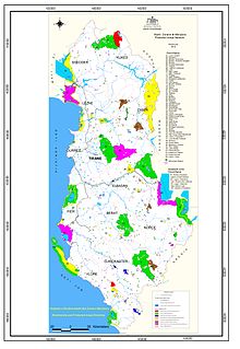
The protected areas of Albania comprise a number of various current designations across the territory of the country. The national policy for governing and management of the protected areas is implemented by the Ministry of Environment and Tourism through the National Agency of Protected Areas of Albania (AKZM). Currently, there are 799 protected areas including 14 national parks, 1 marine park, 2 nature reserves, 22 managed nature reserves, 5 protected landscapes and 770 other protected areas of various categories representing 21.3% of the territory as of 2022. Further a biosphere reserve, 3 world heritage sites, 4 ramsar sites, 45 important plant areas and 16 important bird areas are located in Albania. Meanwhile, the Albanian government has proclaimed the Coastline of Albania and the Tirana Greenbelt as areas of national importance.
Bangham Conservation Park is a protected area in the Australian state of South Australia located in the state's Limestone Coast in the gazetted locality of Bangham about 45 kilometres (28 mi) north-east of the town centre in Naracoorte.

Sea rewilding is an area of environmental conservation activity which focuses on rewilding, restoring ocean life and returning seas to a more natural state. Sea rewilding projects operate around the world, working to repopulate a wide range of organisms, including giant clams, sharks, skates, sea sturgeons, and many other species. Rewilding marine and coastal ecosystems offer potential ways to mitigate climate change and sequester carbon. Sea rewilding projects are currently less common than those focusing on rewilding land, and seas are under increasing stress from the blue economy – commercial activities which further stress the marine environment.
Boyndaminup National Park is a national park in Western Australia. It is located in the Shire of Manjimup in the South West region. It was designated in 2004, and covers an area of 54.43 km2.
Blackwood River National Park is a national park in Western Australia. It extends along the middle reach of the Blackwood River, the largest river in South West Australia. It is located in the shires of Augusta–Margaret River and Nannup in the South West region. It was designated in 2004, and covers an area of 204.75 km2.
Fortress conservation is a conservation model based on the belief that biodiversity protection is best achieved by creating protected areas where ecosystems can function in isolation from human disturbance. Its implementation has been criticized for human rights abuses against indigenous inhabitants when creating and maintaining protected areas.
References
- 1 2 UNEP-WCMC (2022). Protected Area Profile for Ambatoatsinanana from the World Database on Protected Areas. Accessed 11 September 2022.
| Strict Nature Reserves |  | |
|---|---|---|
| National parks |
| |
| Marine National Parks | ||
| Special Reserves | ||
| Other protected areas | ||