
Madagascar, officially the Republic of Madagascar, is an island country comprising the island of Madagascar and numerous smaller peripheral islands. Lying off the southeastern coast of Africa, it is the world's fourth largest island, the second-largest island country and the 44th largest country in the world. Its capital and largest city is Antananarivo.

The ecoregions of Madagascar, as defined by the World Wildlife Fund, include seven terrestrial, five freshwater, and two marine ecoregions. Madagascar's diverse natural habitats harbour a rich fauna and flora with high levels of endemism, but most ecoregions suffer from habitat loss.

The Mangoky River is a 564-kilometer-long (350 mi) river in Madagascar in the regions of Atsimo-Andrefana and Anosy. It is formed by the Mananantanana and the Matsiatra. Another important affluent is the Zomandao River.
Sava is a region in northern Madagascar. Its capital is Sambava. Until 2009 Sava belonged to Antsiranana Province. The region is situated at the northern part of the east coast of Madagascar. It is bordered by the region Diana to the north, Sofia to the west, and Analanjirofo to the south. As of 2018, its population was 1,123,013 and the total area is 25,518 km2 (9,853 sq mi). The region contains wild areas such as Marojejy National Park.

Vakinankaratra is a region in central Madagascar. The capital of the region is Antsirabe. Vakinankaratra covers an area of 16,599 kilometres, and had a population of 2,074,358 in 2018.
Articles related to Madagascar include:

Analamanga is a region in central Madagascar, containing the capital Antananarivo and its surrounding metropolitan area. The region has an area of 17,488 square kilometres, and had a population of 4,325.226 in 2018.

Atsimo-Atsinanana is a region in Madagascar. Its capital is Farafangana. The region used to be part of the Fianarantsoa Province.

Menabe is a region in western Madagascar, with its capital at Morondava. It covers an area of 46,121 square kilometres, and its population was 700,577 in 2018. The population mostly belongs to the Sakalava ethnic group. The region is named after the 18th-century Sakalava Kingdom of Menabe. The name "Menabe", in turn, means "big red", after the color of laterite rock that dominates the landscape.

Menabe Antimena is a protected area in Menabe region of western Madagascar. It belongs to the municipalities of Tsimafana, Beroboka, Bemanonga, Belon'i Tsiribihina, and Tsaraotana.

Analanjirofo is a region in northeastern Madagascar. Until 2009 it was a part of Toamasina Province. It borders Sava Region to the north, Sofia Region to the west, Alaotra-Mangoro Region to the southwest and Atsinanana Region to the south.
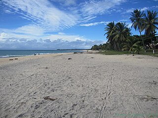
Atsinanana is a coastal region in eastern Madagascar. It borders Analanjirofo region in the north, Alaotra-Mangoro in the west, Vakinankaratra and Amoron'i Mania in the southwest, and Vatovavy in the south. The region contains over 285km of coastline, which includes many beaches and cultural heritage sites.
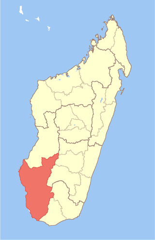
Atsimo-Andrefana is a region of Madagascar. It borders Menabe in north, Amoron'i Mania and Haute Matsiatra in northeast, Ihorombe and Anosy in east and Androy in southeast. The capital is Toliara and the population was 1,799,088 in 2018. Atsimo Andrefana is geographically the largest of all Malagasy regions with an area of 66,236 km2 (25,574 sq mi).

Anosy is one of the 22 regions of Madagascar. It is located in the southeast of the country, on the eastern side of what was once the Toliara Province. The name Anosy means "island(s)" in Malagasy.

Baie de Baly National Park is a National Park in Madagascar.

Namorona is a river in Vatovavy, eastern Madagascar. It flows down from the central highlands, runs along the Ranomafana National Park, forms the Andriamamovoka Falls, to flow into the Indian Ocean. It empties near Namorona and has a length of 103 km (64 mi).

Maroantsetra is a district of Analanjirofo in Madagascar. It hosts part of Masoala National Park and part of Makira Natural Park. The district has an area of 6,965 km2 (2,689 sq mi), and the estimated population in 2020 was 264,234.

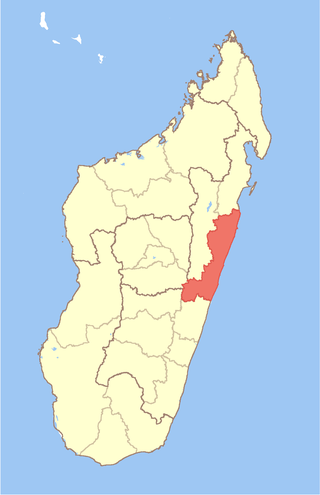
Vatovavy is a region of Madagascar. Its capital is Mananjary. It was created by dividing the former region of Vatovavy-Fitovinany on 16 June 2021.

Ambohijanaka is a suburb and a rural commune in Analamanga Region, in the Central Highlands of Madagascar. It belongs to the district of Antananarivo-Atsimondrano and its populations numbers to 27,088 in 2018.
Ankaraobato is a rural municipality in Analamanga Region, in the Central Highlands of Madagascar. It belongs to the district of Antananarivo-Atsimondrano and its populations numbers to 20,969 in 2019.
