Makay Massif

Last updated
Makay Massif from the air MAKAY2.JPG
Makay Massif from the air

The Makay Massif is a mountain range in western Madagascar.

Contents

Geography and geology

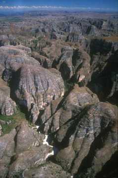
The Makay Massif is situated in the district of Beroroha [1] in the south and Malaimbandy in its north, in the South-East of Madagascar. It covers an area of approximately 4000 km2. It extends north-northeast–south-southwest for approximately 150 km, and is up to 50 km wide. The massif reaches up to 1000 meters elevation. It is deeply dissected by sinuous canyons. It forms part of the boundary between Atsimo-Andrefana Region on the south and east and Menabe Region on the west and north. [2]

Several rivers have their springs in the massif. The Sakeny River rises from the northeastern massif and flows northward to join the Tsiribihina River. Tributaries of the Mangoky River, including the Makay River, drain the southeastern and southern slopes of the massif. The Morondava and Maharivo rise from the western slope, and empty westwards into the Mozambique Channel. [3]

Map of the rivers originating from the Makay Massif Rivers of Makay Mountains OSM.png
Map of the rivers originating from the Makay Massif

The massif's bedrock is principally Isalo II mudstones and sandstones, also known as the Makay Formation. The formation include fossils of Triassic period. [4]

Flora and fauna

The ridges and plateaus generally have sparse vegetation, with species of Didiereaceae and Euphorbiaceae adapted to the thin soils and dry conditions, and some patches of dry forest. In contrast the canyons are home to lush forests, including stands of bamboo, Pandanus , and the palms Ravenea rivularis and Ravenea lakatra . [2] [5]

Native lemurs include the red-fronted lemur (Eulemur rufifrons), Verreaux's sifaka (Propithecus verreauxi), Coquerel's giant mouse lemur (Mirza coquereli), gray mouse lemur (Microcebus murinus), fat-tailed dwarf lemur (Cheirogaleus medius), Phaner cf. pallescens, Lepilemur cf. ruficaudatus, and ring-tailed lemur (Lemur catta). [6] It is also home to the fossa (Cryptoprocta ferox), Madagascar's largest native carnivore. [2]

People

The deeply dissected topography makes the massif mostly impassable. The massif is largely uninhabited, and residents mostly live in villages of 500 or fewer people at the edges of the massif. Herding zebu cattle is an important occupation for inhabitants, and they also rely on forest resources from the massif. [5]

Access

The road to Beroroha (National Road 15) is unpaved and can only been taken by 4x4 cars.

Related Research Articles

<span class="mw-page-title-main">Madagascar subhumid forests</span> Ecoregion in Central Madagascar

The Madagascar subhumid forests are a tropical moist broadleaf forest ecoregion that covers most of the Central Highlands of the island of Madagascar. They are included in the WWF's Global 200 list of outstanding ecoregions. Most of the original habitats have been lost due to human pressure.

<span class="mw-page-title-main">Lake Alaotra</span> Lake in Madagascar

Lake Alaotra is the largest lake in Madagascar, located in Alaotra-Mangoro Region and on the island's northern central plateau. Its basin is composed of shallow freshwater lakes and marshes surrounded by areas of dense vegetation. It forms the center of the island's most important rice-growing region. It is a rich habitat for wildlife, including some rare and endangered species, as well as an important fishing ground. Lake Alaotra and its surrounding wetlands cover 7,223 square kilometres (2,789 sq mi), and include a range of habitats, including open water, reedbeds, marshes, and rice paddies. The lake itself covers 900 km2 (350 sq mi). Lake Alaotra was declared a wetland of international importance under the international Ramsar Convention on February 2, 2003.

<span class="mw-page-title-main">Ankarana Special Reserve</span> Protected area in northern Madagascar

Ankarana Special Reserve is a protected area in northern Madagascar created in 1956. It is a small, partially vegetated plateau composed of 150-million-year-old middle Jurassic limestone. With an average annual rainfall of about 2,000 millimetres (79 in), the underlying rocks have been eroded to produce caves and feed subterranean rivers—a karst topography. The rugged relief and the dense vegetation have helped protect the region from human intrusion.

<span class="mw-page-title-main">Madagascar dry deciduous forests</span> Tropical dry forest ecoregion in Madagascar

The Madagascar dry deciduous forests represent a tropical dry forest ecoregion situated in the western and northern part of Madagascar. The area has high numbers of endemic plant and animal species but has suffered large-scale clearance for agriculture. They are among the world's richest and most distinctive dry forests and included in the Global 200 ecoregions by the World Wide Fund. The area is also home to distinctive limestone karst formations known as tsingy, including the World Heritage Site of Bemaraha.

<span class="mw-page-title-main">Galidiinae</span> Subfamily of carnivores

Galidiinae is a subfamily of carnivorans that is restricted to Madagascar and includes six species classified into four genera. Together with the three other species of indigenous Malagasy carnivorans, including the fossa, they are currently classified in the family Eupleridae within the suborder Feliformia. Galidiinae are the smallest of the Malagasy carnivorans, generally weighing about 600 to 900 g. They are agile, short-legged animals with long, bushy ringed tails.

<span class="mw-page-title-main">Isalo National Park</span> National park in Madagascar

Isalo National Park is a National Park in the Ihorombe Region of Madagascar, in the southwestern corner of the Province of Fianarantsoa. The closest town is Ranohira, and the closest cities are Toliara and Ihosy. It is a sandstone landscape that has been dissected by wind and water erosion into rocky outcrops, plateaus, extensive plains and up to 200 m (660 ft) deep canyons. There are permanent rivers and streams as well as many seasonal watercourses. Elevation varies between 510 and 1,268 m.

<span class="mw-page-title-main">Brown-tailed mongoose</span> Species of carnivore

The brown-tailed mongoose, brown-tailed vontsira, Malagasy brown-tailed mongoose, or salano is a species of mammal in the family Eupleridae. It is endemic to Madagascar. Its natural habitat is moist lowland tropical forest. It is threatened by habitat loss.

Philippia is a formerly accepted genus of plant in the family Ericaceae, now treated as a synonym of Erica. Its species ranged from southern to tropical Africa, Madagascar, and the Mascarene Islands. Philippia was a characteristic Afromontane genus in southern and eastern Africa, found in montane forests and shrublands. The genus name Philippia is in honor of Rodolfo Amando Philippi (1808–1904), who was a German–Chilean paleontologist and zoologist.

<span class="mw-page-title-main">Tsiribihina River</span> River in Madagascar

The Tsiribihina is a river of western Madagascar.

<span class="mw-page-title-main">Onive River</span> River in Madagascar

The Onive River is a river in eastern Madagascar. It flows down from the Ankaratra massif, and is the largest tributary of the Mangoro River.

<span class="mw-page-title-main">Mananara River</span> River in Eastern Madagascar

The Mananara River is one of the main rivers in eastern Madagascar. Its mouth is located at the Indian Ocean near the city of Vangaindrano in the Atsimo-Atsinanana region.

Isalo II, also known as the Makay Formation, is an informal Triassic geological unit in Madagascar.

Microcebus jonahi, or Jonah's mouse lemur, is tiny species of primate. It weighs 60 g and has a body length of around 13 cm and its tail measures around 13 cm as well. It is the 25th recognized species of mouse lemur and the 108th recognized species of lemur.

Analavelona, also known as Analavelona Massif, is a mountain in southwestern Madagascar. The massif is home to an enclave of montane subhumid forest, which is considered a sacred forest by the local people and notable for its biodiversity.

<span class="mw-page-title-main">Sakeny River</span> River in Madagascar

The Sakeny River is a river in Western Madagascar. It is a tributary of the Tsiribihina River.

<span class="mw-page-title-main">Maharivo River</span> River in Madagascar

The Maharivo is a river in Menabe region of western Madagascar. It originates on the Makay Massif and flows westwards into the Indian Ocean. It is approximately 165 km long from source to sea, and drains a basin of 4,700 km2 The climate of the region is semi-arid to arid, and the upper reaches of the river are often dry for part of the year. There are manroves in the river delta. The lower portion of the river and its delta are in Kirindy Mitea National Park.

<span class="mw-page-title-main">Mahavavy Sud River</span> River in Madagascar

The Mahavavy Sud, also known as the Mahavavy South, is a river in western Madagascar. It flows from south to north through the regions of Melaky, Betsiboka, Bongolava and Boeny. It has a length of approximately 1000 km, and drains a basin of 16,475 km2. It is distinct from the Mahavavy Nord several hundred km to the north.

The Sambirano region, also known as the Sambirano domain, is a biogeographic region of northwestern Madagascar. It has a distinctive lowland climate with year-round rain, differing from the rest of seasonally-dry western and northern Madagascar. The climate supports humid lowland rainforests, with greater similarity to those of eastern Madagascar than the dry deciduous forests characteristic of the Madagascar's western lowlands.

<span class="mw-page-title-main">Lake Itasy</span> Lake in Madagascar

Lake Itasy is a lake in central Madagascar. It is located in Itasy Region. It is situated in the municipalities of Ampefy, Soavinandriana, Manazary and Analavory.

<span class="mw-page-title-main">Lily River</span> River in Itasy Region, Madagascar

The Lily River is a river in central Madagascar. It is the main outflow of Lake Itasy, and flows northwestward to join the Sakay River, a tributary of the Tsiribihina.

References

  1. Beroroha
  2. 1 2 3 Le massif du Makay – Aire Protégée du Makay. Accessed 22 November 2022.
  3. Aldegheri, M. (1972). Rivers and Streams on Madagascar. In: Battistini, R., Richard-Vindard, G. (eds) Biogeography and Ecology in Madagascar. Monographiae Biologicae, vol 21. Springer, Dordrecht. https://doi.org/10.1007/978-94-015-7159-3_8
  4. Brenon, P. (1972). The Geology of Madagascar. In: Battistini, R., Richard-Vindard, G. (eds) Biogeography and Ecology in Madagascar. Monographiae Biologicae, vol 21. Springer, Dordrecht. https://doi.org/10.1007/978-94-015-7159-3_2
  5. 1 2 Fromont C, Blanco J, Culas C, Pannier E, Razafindrakoto M, et al. (2022) Towards an inclusive nature conservation initiative: Preliminary assessment of stakeholders’ representations about the Makay region, Madagascar. PLOS ONE 17(8): e0272223. https://doi.org/10.1371/journal.pone.0272223
  6. Dolch, Rainer & Ratsisetraina, Rita & Markolf, Matthias & Ratolojanahary, Tiana & Rakotonirina, Hanitriniaina & Louis, Edward & Wendenbaum, Evrard. (2011). Assessment of lemur diversity in the Makay massif. Lemur news. Volume 16. 48-53.