Antsohihy

Last updated
Antsohihy, Mahajanga
commune urbaine
Rond point d'Antsohihy.png
Flag of Antsohihy Province, Madagascar.svg
Antsohihy.png
Antsohihy
CountryFlag of Madagascar.svg  Madagascar
Region Sofia
District Antsohihy
Area
  Total
20.6 km2 (8.0 sq mi)
Population
 (2018 census)
  Total
38,253
  Density1,900/km2 (4,800/sq mi)
postal code
407
Climate Aw

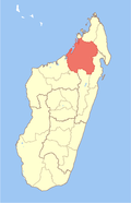
Antsohihy is a city (commune urbaine) in northern Madagascar. It is the administrative capital of the Sofia Region.

Contents

Geography

Antsohihy is the capital of Sofia Region and of Antsohihy District. It is situated at the junction of Route nationale 6 and Route nationale 32. Antsohihy is served by a local airport.

The town is crossed by the Loza River. [1]

Climate

Climate data for Antsohihy (1991–2020)
MonthJanFebMarAprMayJunJulAugSepOctNovDecYear
Record high °C (°F)37.6
(99.7)
36.8
(98.2)
37.3
(99.1)
36.6
(97.9)
36.6
(97.9)
35.8
(96.4)
35.5
(95.9)
37.2
(99.0)
38.2
(100.8)
40.3
(104.5)
39.6
(103.3)
38.9
(102.0)
40.3
(104.5)
Mean daily maximum °C (°F)32.4
(90.3)
32.5
(90.5)
33.3
(91.9)
34.0
(93.2)
33.4
(92.1)
32.0
(89.6)
31.5
(88.7)
32.6
(90.7)
34.1
(93.4)
35.8
(96.4)
35.6
(96.1)
33.9
(93.0)
33.4
(92.1)
Daily mean °C (°F)28.0
(82.4)
28.0
(82.4)
28.3
(82.9)
28.2
(82.8)
27.2
(81.0)
25.6
(78.1)
24.9
(76.8)
25.7
(78.3)
26.9
(80.4)
28.7
(83.7)
29.3
(84.7)
28.7
(83.7)
27.5
(81.5)
Mean daily minimum °C (°F)23.6
(74.5)
23.5
(74.3)
23.3
(73.9)
22.5
(72.5)
20.9
(69.6)
19.1
(66.4)
18.3
(64.9)
18.8
(65.8)
19.6
(67.3)
21.7
(71.1)
22.9
(73.2)
23.5
(74.3)
21.5
(70.7)
Record low °C (°F)19.2
(66.6)
16.2
(61.2)
16.4
(61.5)
16.5
(61.7)
14.7
(58.5)
14.3
(57.7)
13.5
(56.3)
14.5
(58.1)
13.4
(56.1)
15.7
(60.3)
15.7
(60.3)
18.5
(65.3)
13.4
(56.1)
Average precipitation mm (inches)484.3
(19.07)
398.0
(15.67)
302.9
(11.93)
76.2
(3.00)
12.7
(0.50)
5.7
(0.22)
8.5
(0.33)
7.9
(0.31)
8.1
(0.32)
28.0
(1.10)
116.3
(4.58)
255.8
(10.07)
1,704.4
(67.10)
Average precipitation days (≥ 1.0 mm)20.617.913.75.41.91.02.31.42.12.56.714.089.5
Source: NOAA [2]

Nature

Education

The town hosts the annexes of the University Institute of Technology and Agronomy of Mahajanga (IUTAM), the University Institute of Management and Administration (IUGM) and the School of Law and Political Science (EDSP) of the University of Mahajanga.

14°52′34.41″S47°59′0.42″E / 14.8762250°S 47.9834500°E / -14.8762250; 47.9834500

References

  1. jacaranda.fr
  2. "Antsohihy Climate Normals 1991–2020". World Meteorological Organization Climatological Standard Normals (1991–2020). National Oceanic and Atmospheric Administration. Archived from the original on 24 September 2023. Retrieved 24 September 2023.