Mampikony

Last updated
Mampikony
Madagascar location map.svg
Red pog.svg
Mampikony
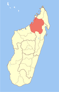
Location in Madagascar
Coordinates: 16°5′30″S47°38′50″E / 16.09167°S 47.64722°E / -16.09167; 47.64722
CountryFlag of Madagascar.svg  Madagascar
Region Sofia
District Mampikony
Elevation
[1]
55 m (180 ft)
Population
 (2018)census
  Total
28,593
Time zone UTC3 (EAT)
Postal code
414
Carte bassin Sofia Carte bassin Sofia.svg
Carte bassin Sofia

Mampikony urban municipality in northern Madagascar. It belongs to the district of Mampikony, which is a part of Sofia Region. The population of the municipality was 28,593 in 2018.

Contents

Mampikony is located at the Route nationale 6 and served by the local Mampikony Airport. The town provides access to hospital services to its citizens. [2]

Geography

It is situated at 84 km from Ambondromamy on the Route nationale 6 and the Mampikony River, an affluent of the Bemarivo River.

Religion

Economy

Cotton and tobacco [3] plantations. The majority 75% of the population of the commune are farmers, while an additional 10% receives their livelihood from raising livestock. The most important crops are rice and onions; also cassava is an important agricultural product. Services provide employment for 15% of the population. [2]

A thermic central of Jirama is localized in this town.

Protected areas

References and notes

  1. Estimated based on DEM data from Shuttle Radar Topography Mission
  2. 1 2 "ILO census data". Cornell University. 2002. Retrieved 2008-03-02.
  3. Dilag-tours.ch - Mampikony
  4. AIRE PROTEGÉE[sic] CORRIDOR FORESTIER BONGOLAVA, DISTRICTS DE MAMPIKONY ET DE PORT-BERGÉ,