
Maasbracht is a town in the southeastern Netherlands. It was a separate municipality until January 1, 2007, when it became a part of the new municipality of Maasgouw. Football player Mark van Bommel was born in Maasbracht.

Maasbree is a former municipality and a town in southeastern Netherlands. Until 1818, the municipality was just called "Bree".
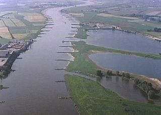
The Pannerdens Kanaal is a canal in the Netherlands that was dredged between 1701 and 1709 to cut off a large, shallow bend of river Rhine and so improve river traffic and water regulation.

Heel is a town and former municipality in the southeastern Netherlands. The town is located near the E25 motorway and the river Meuse.

Doornenburg is a village to the south east of Angeren in the municipality of Lingewaard, Gelderland, the Netherlands. It has a population of 2709.

Pernis is a neighborhood and submunicipality of Rotterdam, Netherlands. The district has a population of 4,845 (2018) on a total area size of 1.60 km². Pernis is thus a full submunicipality of Rotterdam, but the former independent municipality had its own district council already. Although surrounded by ports, Pernis has preserved its village-like atmosphere very well.

Asenray is a town in the Dutch province of Limburg. It is a part of the municipality of Roermond, and lies about 3 km east of Roermond.
Leerbroek is a village in the Dutch province of Utrecht. It is a part of the municipality of Vijfheerenlanden, and lies about 9 km (6 mi) northeast of Gorinchem.
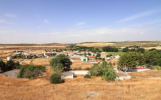
Huelves is a municipality in Cuenca, Castile-La Mancha, Spain. It has a population of 53.

Bystrička is a village and municipality in Martin District in the Žilina Region of northern Slovakia.

Fort Pannerden is a disused military fort situated near the village of Pannerden in the southeast of the Netherlands. In November 2006, it became the focus of national news stories because a group of squatters were evicted in a large-scale operation by police, helped by the army. Later on in the same month, it was resquatted.

Elden is a village in the Dutch province of Gelderland. It is located in the municipality of Arnhem, about 4 km southwest of the city centre.

Herwen is a village in the Dutch province of Gelderland. It is located in the municipality of Rijnwaarden.
Sprang is a village in the Dutch province of North Brabant. It is located in the municipality of Waalwijk, about 12 km north of Tilburg.

Kedichem is a village in the Dutch province of Utrecht. It is located about 7 km northeast of the city of Gorinchem, in the municipality of Vijfheerenlanden.
Zuidwijk is a former municipality in the Dutch province of South Holland. It was located southeast of the center of Boskoop.

Garlitos is a municipality located in the province of Badajoz, Extremadura, Spain. According to the 2005 census (INE), the municipality has a population of 725 inhabitants.

Llangathen is a community located in Carmarthenshire, Wales. The population taken at the 2011 census was 507.

Smolarze is a village in the administrative district of Gmina Popów, within Kłobuck County, Silesian Voivodeship, in southern Poland. It lies approximately 4 kilometres (2 mi) west of Popów, 16 km (10 mi) north of Kłobuck, and 90 km (56 mi) north of the regional capital Katowice.
Přistoupim is a village and municipality in Kolín District in the Central Bohemian Region of the Czech Republic.

